|
Getting from one point of Cape Lookout National Seashore to another can be a challenge. With only two destinations accessible by roads on the mainland and five different departures sites to access our 56 miles worth of beach via ferry, it helps to know where you're going and how to get there. Mainland Visitor Centers & Offices | Barrier Island Destinations
Only two sections of Cape Lookout National Seashore can be reached by car (without taking a vehicle ferry): the Harkers Island Visitor Center and Park Headquarters and the Beaufort Visitor Information Center. Harkers Island Visitor Center & Administrative OfficesThis visitor center is located on the eastern end of Harkers Island, approximately 20 mi (30 km) east of Beaufort, NC and 30 mi (50 km) south of the Cedar Island terminus of the North Carolina State Ferry route from Ocracoke Island to Cedar Island. This visitor center is one of two Ferry Gateways to the Cape Lookout Light Station and Shackleford Banks. From Beaufort or Morehead City: Follow US 70 EAST. Turn right onto Harkers Island Road (SR 1332/SR 1335). Follow Harkers Island Road until it terminates. On the left is the two-story visitor center. From Cedar Island: Take NC 12 SOUTH past the Atlantic turnoff to US 70 WEST. Continue on US 70 to Harkers Island Road (SR1332/SR 1335). Turn left onto Harkers Island Road and follow it until it terminates. On the left is the two-story visitor center.
The islands within the seashore are reached only by boat, either your personal boat or one of the privately operated ferries. Ferry contact information can be found on the Ferry Services webpage. 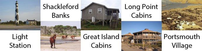
Cape Lookout Light StationPassenger ferries leave for the Cape Lookout Light Station from the Harkers Island Visitor Center throughout the year. Ferries leave for the Light Station from the Beaufort Visitor Information Center in the summer and by request at other times of the year. Cape Lookout Village & Point of Cape LookoutThis historic village is located 2 miles south of the Cape Lookout Lighthouse and 14 miles south of the Great Island Cabin Camp; the village entrance road is across from Ramp 42b on the "backroad." The point of Cape Lookout is located 3 miles south of the lighthouse, at Mile 44 of the park. After taking a passenger ferry to the light station, the village can be accessed by the Beach Shuttle truck service which runs from the Cape Lookout Light Station to the village and point of Cape Lookout or the village can be reached by hiking on the open beach. If you plan to hike to the village, be sure to give yourself enough time to return and take plenty of water and snacks with you. You can also take the vehicle ferry to the Great Island Cabin Camp and drive your personal vehicle to the village. Shackleford BanksPassenger ferries leave for the west end of Shackleford Banks from the Beaufort Visitor Information Center throughout the year. Ferries leave for the east end of Shackleford Banks from the Harkers Island Visitor Center in the summer and by request at other times of the year. Great Island Cabin Camp & Vehicle Access to South Core BanksThe Great Island Cabin Camp can be reached by ferries from the town of Davis, NC. These ferries can carry both passengers and four-wheel drive vehicles. From Beaufort or Morehead City: Follow US 70 EAST to the town of Davis. For Cape Lookout Cabins & Camps Ferry Service, continue straight onto Horseshoe Road. Continue straight onto Grady Davis Lane and the ferry is on the left. For Davis Shore Ferry Service, turn right onto Community Road (SR 1363) then turn left onto Willis Road. The ferry is on the right. From Cedar Island: Take NC 12 SOUTH past the Atlantic turnoff to US 70 WEST. Continue on US 70 to the town of Davis, NC. For Davis Shore Ferry Service, continue straight on Community Road (SR 1363) then turn left onto Willis Road. The ferry is on the right. For Cape Lookout Cabins & Camps Ferry Service, turn left onto Horseshoe Road. Continue straight onto Grady Davis Lane and the ferry is on the left. Long Point Vehicle Access to North Core BanksLong Point on North Core Banks is the landing site for the vehicle ferry coming from the town of Atlantic, NC. This ferry can carry both passengers and four-wheel drive vehicles. All access to Long Point and North Core Banks is by boat/ferry, there is no road to this island. From Beaufort or Morehead City: Follow US 70 EAST. Where US 70 meets NC 12, turn right to stay on US 70 (Seashore Drive). Turn left onto Morris Drive. At the end of the road, turn right onto Shell Road (SR 1378). Shell Road becomes Morris Marina Road. The ferry is on the right. From Cedar Island: Take NC 12 SOUTH and turn left onto Old Cedar Island Road. Turn left onto Morris Marina Road (SR 1378) and the ferry is on the right. Portsmouth VillageThe primary route to Portsmouth Village, located on the very northern end of North Core Banks (sometimes referred to as "Portsmouth Island"), is by passenger ferry from Ocracoke, NC. Reservations for this ferry are recommended, and can be made by calling the ferry directly at 252-928-4361. Reaching Ocracoke and the ferry to Portsmouth is also only accomplished by taking a ferry from either Hatteras Island or Cedar Island. There are no roads to either Ocracoke or to Portsmouth Village. From the Hatteras to Ocracoke Ferry Terminal: Follow NC 12 SOUTH to Ocracoke Village. The ferry service is on the left at 271 NC 12 (Irvin Garrish Hwy). From Morehead City or Beaufort: Follow US 70 EAST. Where US 70 meets NC 12, continue straight on to NC 12 NORTH until it terminates at the Cedar Island to Ocracoke ferry terminal. Take the state ferry to Ocracoke Island. Turn right to continue on NC 12 NORTH. The ferry service is on the right at 271 NC 12 (Irvin Garrish Hwy). |
Last updated: May 6, 2024