East Rim Wilderness Trail Descriptions

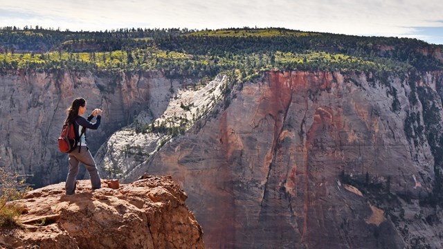
Perched on the rim of a canyon, looking down the length of Zion Canyon is laid out before you
The view from Observation Point of Zion Canyon.

NPS Photo

 
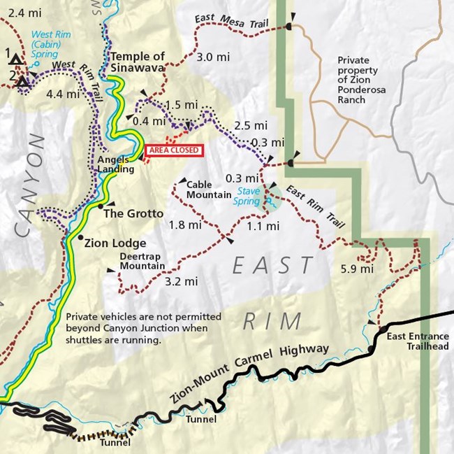
Planning map of the East Rim of Zion National Park. Weeping Rock TH closure is labeled.
Download the Wilderness Guide from our website for a full map of the Zion Wilderness.

Trail Descriptions

These are not loop hikes. The trail distances listed may be for out-and-back trips or one-way. Hikers do not need to do the full distance, they may turn around at any point and return the same way they came. All overnight camping trips require a Wilderness Permit.

Canyon Overlook Trail

Trailhead Location: Located near the east entrance of the Zion-Mount Carmel Tunnel.
Roundtrip Distance: 1.0 mi / 1.6 km
Elevation Change: 163 ft / 50 m
Estimated Hiking Time: 1 hour
Description: Long drop-offs, mostly fenced. Rocky and uneven trail ends at a viewpoint for Pine Creek Canyon and lower Zion Canyon. Parking is extremely limited, be prepared to try multiple times.

East Rim Trail

Trailhead Location: East Rim Trailhead on the Zion-Mount Carmel Highway, located 100 feet west of the East Entrance fee booths. Also accessible from the Stave Spring Trail at the Stave Spring Trailhead.
Distance (one way): 5.9 miles (9.5 km) to Stave Spring and 10.6 miles (17.0 km) to Observation Point.
Elevation Change: 1,000 ft / 300 m to Stave Spring
Estimated Hiking Time: 6 hours roundtrip to Stave Spring, 8-14 hours roundtrip to Observation Point.
Description: The trail heads up to the plateau with views of sandstone cliffs all around. A hike through ponderosa forest eventually leads to Stave Spring and the junction with Deertrap and Cable Mountain, or hikers can continue on the East Rim Trail and descend down into Echo Canyon towards Observation Point. ⚠️Due to major rockfall, this trail does not connect with any trails in Zion Canyon.

East Mesa Trail to Observation Point

Trailhead Location: The East Mesa Trailhead is only accessible by high-clearance / 4-wheel-drive dirt roads off the North Fork Road. Roads can be extremely muddy and inaccessible in the winter, spring, and after rainstorms. Please be respectful of private property near the East Mesa Trailhead.
⚠️ Only park in designated spaces. Do not park on private property. Illegally parked vehicles may be cited or towed at the owner's expense.
Distance (roundtrip): 6 miles (9.6 km) to the East Rim Trail and back. 6.8 miles (11 km) to Observation Point and back.
Elevation Change: 300 ft / 90 m to East Rim Trail or Observation Point and back.
Estimated Hiking Time: 3 hours to Observation Point and back.
Description: Hike through ponderosa and pinyon/juniper forest, with brief views into the surrounding canyons, before reaching the East Rim Trail. Continue on the East Rim Trail for another 0.4 miles to Observation Point.

Stave Spring Trail

Trailhead Location: Stave Spring Trailhead, accessible by high-clearance / 4-wheel-drive dirt roads off of the North Fork Road.
Distance (one way): 0.3 miles / 0.5 km
Elevation Change: 50 feet / 15 m
Estimated Hiking Time: 15 minutes
Description: This trail provides access to the East Rim Trail, connecting with it near Stave Spring. Stave Spring is a pipe sticking out of the ground that provides water (after treatment) to overnight hikers. It is not a scenic destination.

Deertrap Mountain Trail

Trailhead Location: No trailhead. Accessible via the East Rim Trail, off the junction near Stave Spring.
Distance (roundtrip): 20.4 miles (32.8 km) from the East Rim Trailhead to Deertrap Mountain and back. 9.8 miles (15.8 km) from the Stave Spring Trailhead to Deertrap Mountain and back.
Elevation Change: 700 feet / 210 m. This elevation change does not include elevation gained or lost on the Stave Spring or East Rim trails, which are used to access the Deertrap Mountain Trail.
Estimated Hiking Time: 3-4 hours from East Rim Trail to Deertrap Mountain and back.
Description: Hike along the East Rim with views into the canyons to the north and south, going up and down small dips until reaching the edge of Deertrap Mountain with views into Zion Canyon.

Cable Mountain Trail

Trailhead Location: No trailhead. Accessible via the Deertrap Mountain Trail, off the East Rim Trail, near the Stave Spring junction.
Distance (roundtrip): 17.6 miles (28.3 km) from the East Entrance Trailhead to Cable Mountain and back. 7 miles (11.2 km) from the Stave Spring Trailhead to Cable Mountain and back.
Elevation Change: 200 feet / 60 m. This elevation change does not include elevation gained or lost on the Stave Spring or East Rim trails, which are used to access the Deertrap Mountain Trail.
Estimated Hiking Time: 1-2 hours from the Deertrap Mountain Trail to Cable Mountain and back
Description: Hike from the Deertrap Mountain Trail along a mesa to the edge of Cable Mountain, with views into Zion Canyon. A historic landmark, the Cable Mountain Cableworks, stands on the rim, providing a glimpse into the history of early 20th century settlers and their logging operations in the area.


Group Size Limits

Large groups result in larger impacts. Trails in the Zion Wilderness have a group size limit in order to help protect the wilderness character of the area. Group size limits are strictly enforced. Groups are limited to a maximum of 12 people that share the same affiliation (e.g., school, club, scout group, colleagues, family, friends, or a combination thereof).
Groups that exceed these limits may not split up and visit the same drainage or wilderness trail on the same day, but may split up and visit different areas.

Restrooms

Water filling stations are not available at any of these trailheads. Fill your water before you arrive. Pit toilets are located at the Canyon Overlook Trailhead and the East Rim Trailhead. Always use the restroom before hiking. If you are on the trail, be prepared to pack out human waste, toilet paper, diapers, and hygiene products. Human waste disposal bags are highly recommended to transport solid waste. Please follow Leave No Trace principles while in the park.

Pets

Pets are not permitted on these trails. The only trail for pets is the Pa'rus Trail.

Last updated: November 17, 2022

Park footer

Contact Info

Mailing Address:

Zion National Park
1 Zion Park Blvd.

Springdale, UT 84767

Phone:

435-772-3256
If you have questions, please email zion_park_information@nps.gov. Listen to recorded information by calling anytime 24 hours a day. Rangers answer phone calls from 11:30 a.m. to 3 p.m. and 3:30 p.m. to 5 p.m. MT, but a ranger may not answer if they are already speaking with someone else.

Contact Us