Last updated: August 18, 2024
Thing to Do
Hiking at Wind Cave
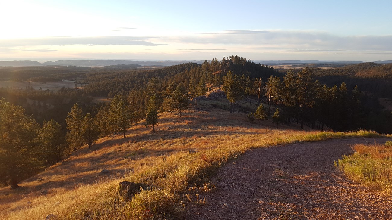
Photo by Michael Reid
Though most visitors come to see the cave, Wind Cave has many surface activities, including hiking. Over 30 miles of hiking trails meander through pristine mixed-grass prairie and ponderosa pine forest. Mileages listed below are one way unless otherwise noted.
Details
Activity
Hiking
Pets Allowed
No
Leashed pets are only allowed on the Prairie Vista Trail and Elk Mountain Campground Trail. Pets are not allowed on other trails.
Activity Fee
No
Entrance fees may apply, see Fees & Passes information.
Reservations
No
Season
Year Round
Time of Day
Day, Dawn, Dusk
During the summer months, the best time to start your hike is in the morning when it is cooler. Afternoon temperatures regularly exceed 90° F (32° C).
If you plan on camping in the backcountry overnight, you must fill out a free backcountry permit at the visitor center first.
If you plan on camping in the backcountry overnight, you must fill out a free backcountry permit at the visitor center first.
Accessibility Information
Wind Cave Canyon Trail is a gravel service road with uneven terrain and occasionally steep grades that may be difficult for those using wheelchairs.
Part of the Rankin Ridge Trail follows an old gravel service road to the wayside exhibit at the top. This road has a steep grade and rugged, loose terrain that is not suitable for those using wheelchairs.
The trailheads for the Elk Mountain Campground Trail and Sanctuary Trail have paved accessible parking but the trails are not wheelchair accessible.
Preparing for Your Hike
-
Carry and drink plenty of water. There are few water sources and all water in the backcountry must be boiled, filtered, or treated.
-
Wear fully enclosed footwear and long pants as poison ivy and ticks may be encountered anywhere in the park. It's also recommended to bring a wide brimmed hat, sunscreen, and bugspray.
-
Bring a park map.
-
Check the weather forecast before starting and bring extra layers. During the summer, afternoon temperatures regularly exceed 80°F (27°C) and strong thunderstorms with large hail are common.
-
There are two pet friendly trails in the park, the Prairie Vista Trail and Elk Mountain Campground Trail. Pets are not permitted on any other trail.
-
Large wildlife including bison (buffalo) and mountain lions roam throughout the park. Be aware of your surroundings at all times. Visitors must stay at least 25 yards from all wildlife, although it is strongly recommended to stay farther away from bison. Bison may appear tame but are unpredictable and dangerous and may charge without warning.
-
Topographic maps of the Black Hills can be purchased at the visitor center bookstore. Off-trail hiking is allowed and may be the best way to avoid large wildlife.
-
Remember that all park resources -- rocks, antlers, bones, plants, animals, and artifacts -- are to remain as you find them. All visitors are entitled to the same sense of discovery you experience when traveling the park trails, and collecting these items is illegal.

NPS Photo
Easy Trails
Prairie Vista
Approximately 1 mile / 1.6 km (round trip)
Stroll the prairie grasslands from the visitor center. Waysides provide information along the way.
Trailhead: Begin this loop trail at the Visitor Center or at the picnic area, located 1000 feet north of the visitor center.
Elk Mountain
1 mile / 1.6 km (round trip)
The grassland and forest meet on this trail around the campground. During September and October, elk may be heard bugling at dawn and dusk.
Trailhead: Located in the Elk Mountain Campground, across from the amphitheater.
Rankin Ridge
1 mile / 1.6 km (round trip)
Gain spectacular views from the highest point in the park. This nature trail, like those above, is a loop great for families or those with little time to explore. Though the fire tower is closed to the public, on a clear day, you may be able to see as far as the Badlands from the trail's eastern edge.
A short guide for this trail may be purchased from the bookstore.
Trailhead: Follow Highway 87 toward Custer State Park, and look for signage leading towards Rankin Ridge Nature Trail. RVs and trailers are not permitted at trailhead; hikers may also park at nearby pulloff and walk to trailhead (approx. 1200 feet to trailhead).
Wind Cave Canyon
1.8 miles / 2.9 km
This former road follows Wind Cave Canyon to the park boundary. Limestone cliffs provide nesting areas for cliff swallows, canyon wrens, and great horned owls. Look for Red-headed and Lewis' woodpeckers among the snag trees of forested hillsides.
Trailhead: Located along Highway 385 just east of the visitor center. Look for the gravel parking area east of the road.
Moderate Trails
Cold Brook Canyon
1.4 miles / 3.5 km
This trail winds through Cold Brook Canyon to the park boundary. Along the way a ponderosa forest gives way to the open prairie and crosses a prairie dog town, a good place to see prairie falcons and other raptors.
Trailhead: Located along Route 385 approximately 1 mile south of the visitor center.
Lookout Point
2.2 miles / 3.5 km
Follow the rolling hills of the prairie across Lookout Point to Beaver Creek. A side trip up to Lookout Point offers views of the American Elk Prescribed Fire from 2010. This trail can be combined with part of the Highland Creek and Centennial trails to make a 4.5-mile loop.
Trailhead: Located along Route 87 north of the visitor center.

NPS Photo
Strenuous Trails
East Bison Flats
3.7 miles / 6 km
Hike one-half mile down the Wind Cave Canyon Trail to reach the East Bison Flats Trail where a brief, steep climb leads to the rolling hills of the praririe. Panoramic views of the prairie, Buffalo Gap and the Black Hills await.
Trailhead: Located just north of the park's southern boundary along Route 385.
Sanctuary
3.6 miles / 5.8 km
This trail follows the rolling hills of the prairie, crosses a large prairie dog town, and ends where it meets the Highland Creek Trail.
Trailhead: About one mile north of the Rankin Ridge fire tower turnoff.
Centennial
6 miles / 9.7 km
This section is the southernmost part of a 111-mile trail through the Black Hills, ending at Bear Butte State Park. Here it crosses prairies, ponderosa forests, and winds along Beaver Creek. Part of this trail can be combined with part of the Highland Creek and Centennial trails to make a 4.5-mile loop.
Trailhead: This trail can be reached by Hwy 87 or NPS 5.
Highland Creek
8.6 miles / 13.8 km
This trail is the longest and most diverse trail in the park, crossing mixed-grass prairies, ponderosa pine forests, and riparian habitats of Highland Creek, Beaver Creek, and Wind Cave Canyon.
Trailhead: This trail can be reached by a 1-mile hike down the Wind Cave Canyon trail or from the northern trailhead on NPS 5.
Boland Ridge
2.6 miles / 4.2 km
A series of climbs offer panoramic views of the Black Hills, Red Valley, and the plains beyond. Elk are often seen from this trail in the morning and evening.
Trailhead: The trail begins at a small parking area on NPS 6, one mile north of the junction with NPS 5.

NPS Photo
Open Hike Policy
Wind Cave National Park is an open hike park meaning visitors are welcome to hike off designated trails.
If you decide to explore the park and hike away from established trails, please make sure to bring plenty of water, a map, and be aware of your surroundings at all times. Bison and other wildlife roam throughout the park and cell service within the park is very limited.