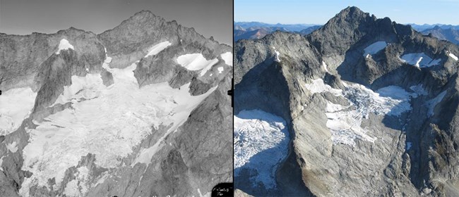
(L) Post 1960, (R) Scurlock 2005 IntroductionNorth Cascades National Park Service Complex encompasses 681,158 acres of rugged mountains and valleys spanning the crest of the Cascade Range from the Canadian border south to Lake Chelan. The park has three regional climates and numerous microclimates that result in a high diversity of flora and fauna. There are 42 square miles of glaciers that provide cold fresh water to the rivers and streams supporting the region’s fisheries, recreation and the hydroelectric and agricultural industries. Climate change has already affected park resources, recreational opportunities, and park management. 
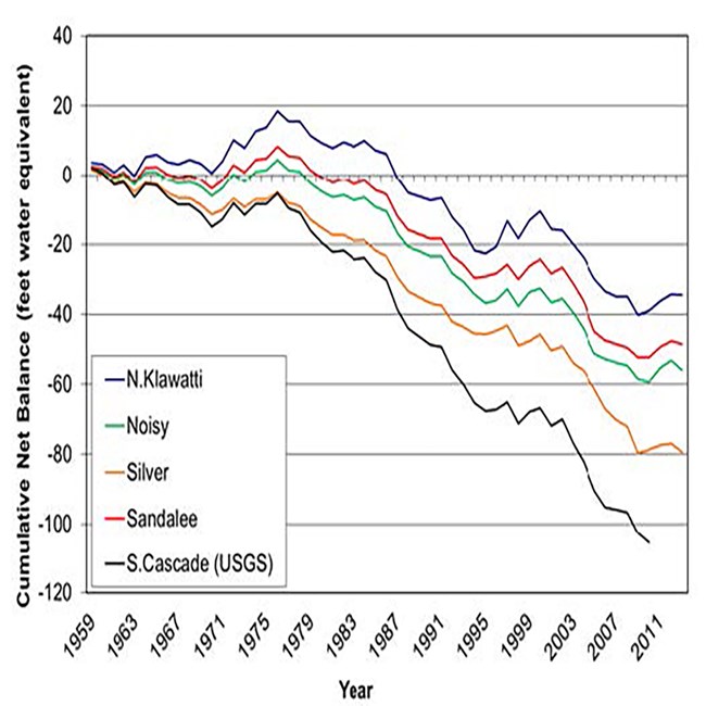
Observed Climate EffectsMountain SnowpackMean winter minimum temperatures at high elevation stations (above 4000 ft.) have risen about 5°F since 1950s. As a result, the mean winter freezing level in this region has risen about 650 ft. since 1950 resulting in diminished mountain snowpack. GlaciersGlaciers at North Cascades have lost 53% of their area since 1900 AD. The rapid loss is driven by warmer air temperatures, which increase the rate of summer melt and decreases winter snowfall (Figure 1 and 2). Glaciers currently provide 6-18% of the runoff to the Skagit River; the largest river flowing into Puget Sound also drains 70% of the park. The net loss of glaciers has resulted in the loss of 400 billion gallons of water to the Skagit River, equivalent to 44 years of water supply for Skagit County. StreamflowPark streams at higher elevations and east of the Cascade crest have shown a response to warmer temperatures. Since the late 1970s, the Stehekin River’s peak annual flow event has shifted from spring to fall, and three 100 year floods have occurred since 1995. Endangered SalmonidsRivers and streams in North Cascades provide some of the most protected, high quality habitat for bull trout, steelhead and Chinook salmon in the Puget Sound basin. Bull trout, the most sensitive of these species, need water temperatures < 55°F. Current NPS monitoring in 13 major stream systems in the park indicate that 7 of these systems already exceed the temperature criteria for bull trout. Forest LineForest line has moved up roughly 415 feet over the last 50 years. Tree establishment in subalpine and alpine areas is expected to accelerate with warmer summer temperatures, decreased snow pack, and earlier snow melt. 
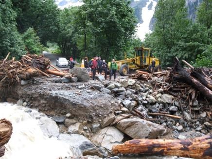
Projected Climate EffectsMean annual temperatureMean annual temperature is expected to continue to increase in the Pacific Northwest, warming on average by 2.0°F by the 2020s, 3.2°F by the 2040s, and 5.3°F by the 2080s (Mote and Salathé 2010). Recreational AccessAccess to the park will be severely impacted by changing hydrologic conditions. Currently, 78% of our roads and 97% of our trails are in snow dominated watersheds where spring peak flows are the norm. By the 2040s, the majority of roads and trails will be in transient watersheds with higher and more frequent peak flows in both spring and fall. Many culverts and bridges will be vulnerable to these increased flows resulting in decreased access (Figure 3). WolverinesWolverines were extirpated from the Sierra Nevada in the mid-20th century. Today, the Cascade Range provides the southern extent of wolverine range in the PNW. Wolverines give birth in snow caves and are restricted to areas where at least 5’ of snow cover persists until mid-May. In 2012, one of only two known wolverine reproductive dens was located in the park. Decreasing snowpacks will shrink wolverine habitat “islands” during the next century threatening species persistence in a key portion of their current range. Whitebark PineWhitebark pine survival is threatened by the introduced white pine blister rust and the native mountain pine beetle. In the park, 28% of whitebark pine trees are dead, 30% are infected with blister rust, and 1% have died from mountain pine beetles. Warming winter temperatures may facilitate mountain pine beetle survival resulting in increased whitebark pine mortality. Citizen Science and ButterfliesButterfly distributions are expected to shift in response to air temperature. Volunteers in the Cascade Butterfly Program monitor butterflies in North Cascades and Mount Rainier. Montane WetlandsThe loss and alteration of high elevation, shallow wetlands are projected to result from reductions in snowpack, higher evapotranspiration, and extended summer droughts. These ecologically productive areas provide core habitat for amphibians and invertebrates, and food and water for a wide range of montane birds and mammals. We are conducting research to identify vulnerable wetlands and improve our management of these unique habitats. PikasNorth Cascades is on the northern edge of the distribution of pika in the US and the range core for the entire lineage. We are working with geneticists from UBC and U. of Colorado to understand how or if pikas can adapt in a climatically heterogeneous landscape. Our studies will inform local conservation and contribute to trans-boundary wildlife management issues. Adaptive ManagementNorth Cascadia Adaptation Partnership (NCAP)The park is working with Mount Rainier, Mount Baker-Snoqualmie NF, and Okanogan-Wenatchee NF to develop climate adaptation strategies and tactics for implementation across 6 million acres of the northern Cascade Range. Management PlanningIn response to several large floods, the park completed the Stehekin River Corridor Implementation Plan in 2013. The plan addresses flooding of private land and threats to access and infrastructure. Increasing Mountain Lake ResilienceNon-native fish stocked in park lakes threaten the long-term viability of native salmon and trout and have reduced the habitat available for amphibians. Lake restoration projects have removed non-native fish, expanding amphibian breeding habitat in 8 lakes and eliminating 3 populations of highly invasive non-native Eastern brook trout. Access ManagementMaintenance and resource management staff are working to improve inventories of road and trail infrastructure. Data will be combined with projected hydrologic flows to improve park protection of aquatic ecosystems and recreational access. |
Last updated: January 30, 2018
