
NPS/Louise McLaughlin Caution Visiting Nuttallburg

Nuttallburg YesterdayNuttallburg was one of almost fifty towns that sprang up along the New River in response to a growing nation's need for coal 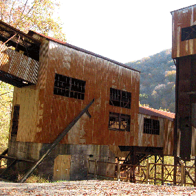
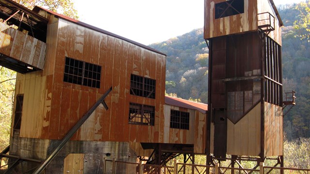
NPS photo/Dave Bieri Nuttallburg TodayIn 1998 the Nuttall family transferred ownership of Nuttallburg to the National Park Service. The site was inventoried, documented, and in 2005, listed on the National Register of Historic Places. In 2011 the National Park Service completed a multi-year project that involved clearing vegetation and stabilizing structures. Today it is considered one of the most intact examples of a coal mining complex in West Virginia and one of the most complete coal related industrial sites in the United States. Visiting NuttallburgUse caution when driving to Nuttallburg. The road to Nuttallburg (Keeneys Creek Road) is narrow, winding, and steep. Some places are paved while some places are gravel. Much of the road is one lane, meaning that drivers will need to pull off the side of the road to allow for passing vehicles. Large vehicles and trailers are not recommended. Driving to NuttallburgFrom Canyon Rim Visitor Center, go north on US 19 0.3 miles to the next intersection, and turn right onto Lansing-Edmond Road (County Route 5/82). Follow Lansing-Edmond Road (becomes CR 82) 6.0 miles to Winona. Turn right onto Keeneys Creek Road (CR 85/2), continue past the houses (do not cross the creek) and the road turns to gravel. Travel 4.1 miles to the main Nuttallburg parking area and restroom. Accessible parking is located an additional 0.1 miles beyond the main parking area, closer to the tipple. Winona can also be reached from the Canyon Rim Visitor Center by traveling north on US 19 to Hico 5.0 miles. Go east on US 60 (Midland Trail) 4.4 miles to Lookout, turn right onto Lansing-Edmond Road (CR 82) and go 2.1 miles to Winona, then follow the directions above for Keeneys Creek Road (CR 85/2). Along the WayYou will be passing through what was once Nuttallburg's African American community before you reach the main parking area. Exhibit panels located at pull-offs along the road interpret this and other features. Stop on the drive in or walk the short distance back from the main parking area to get a better picture of what life was like in the historic community. Hiking to the HeadhouseThe easiest way to the headhouse area of Nuttallburg is located off Beauty Mountain Road near Lansing. From U.S. 19, take Lansing-Edmond Road (CR 5 becomes CR 82) 2.5 miles and turn right onto Beauty Mountain Road (CR 85/5). Travel 0.13 miles, then turn right into the Short Creek Trailhead parking. A short set of steps from the top end of the lot leads left to a gate that is the start of the Headhouse Trail. Hike down the trail (an old administrative road) 0.75 miles to the headhouse area of Nuttallburg. Caution: this hike is steep and strenuous. 
Nuttallburg Photo Gallery
View images of the coal mining town of Nuttallburg. 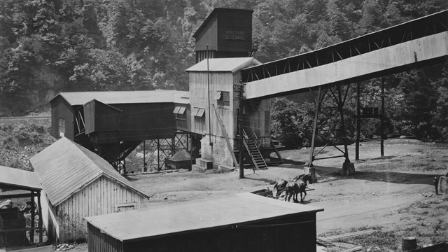
Historic Nuttallburg Photo Gallery
View historic images of Nuttallburg. 
Explore the Gorge Video: Nuttallburg
Explore the Nuttallburg townsite with Park Ranger Billy Strasser. |
Last updated: February 21, 2026