NPS A dramatic view of the Missouri National Recreational River awaits visitors at Mulberry Bend Overlook. From the parking area, a short paved trail leads to two overlooks that offer views of a free flowing segment of the Missouri. This portion of the river exhibits characteristics that were common hundreds of years ago but are no longer seen on the "man-made" portions of the river. At the first overlook, exhibits provide information about the national park and early American Indians who inhabited the region. At the uppermost overlook, exhibits interpret the river's hydrology, the surrounding forest and a flood that devastated the town of Vermillion in 1881. The paved trail rises 60 feet to the top and is wheelchair accessible to the first overlook. A picnic table and vault toilet is available near the parking lot. History of Mulberry BendThe section of the Missouri River surrounding Mulberry Bend not only has exceptional views, but also a rich historical legacy. The first known inhabitants were American Indian tribes which settled the area as early as 6,000 years ago. These groups built villages consisting of permanent houses covered with earth and wood. The Mulberry Bend area was visited on August 24, 1804 by the Lewis and Clark Expedition. Their team explored the areas surrounding the river, including Spirit Mound. Clark writes in his journal of an abundance of deer present in the area, which the crew hunted for food. Lewis and Clark traveled on a very different river than the one today, partly due to the Missouri River Flood of 1881. Massive blocks of ice and the thawing river created a new river channel (present-day Mulberry Bend), rerouting the Missouri River five miles south and destroying the town of Vermillion. 
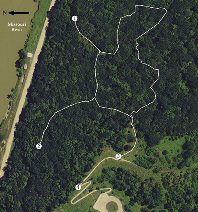
NPS Photo Mulberry Bend TrailThis moderately strenuous unpaved trail begins at the upper viewpoint at the end of the paved trail. It is a 3/4 mile trail consisting of a loop with 2 spurs to viewpoints overlooking the river. The route winds through dense bluff forest of bur oak, cedar, ash, and other native trees. Getting ThereTake South Dakota Highway 19 south from Vermillion (it becomes Nebraska Highway 15 as soon as you cross the bridge) or Nebraska Highway 15 north toward Vermillion. The overlook is on the east side of the highway in Nebraska. Trail BrochuresA trail brochure is available either at trailhead, by visiting Park Headquarters or requesting an electronic version via email. Points of Interest1. Bluff OverlookBeautiful downstream views of the Missouri River can be seen from this vista. Sandbars on the north side of the river provide habitat for white-tailed deer, shorebirds, and cottonwoods.2. Oak OverlookLooking upstream you can see the Vermillion-Newcastle bridge spanning the gap between Nebraska and South Dakota. Cliff swallows often build nests under the bridge.3. River Bend VistaBefore or after your hike, spend some time enjoying the picturesque view of the Missouri. This is one of the highest elevation points at the Mulberry Bend property.4. Village VistaLearn about the rich culture that the area has to offer. Displays located along the concrete trail explore the history of American Indian tribes that settled here.Identification GuidesAll plant identification guides are available below or by requesting an electronic version via email.

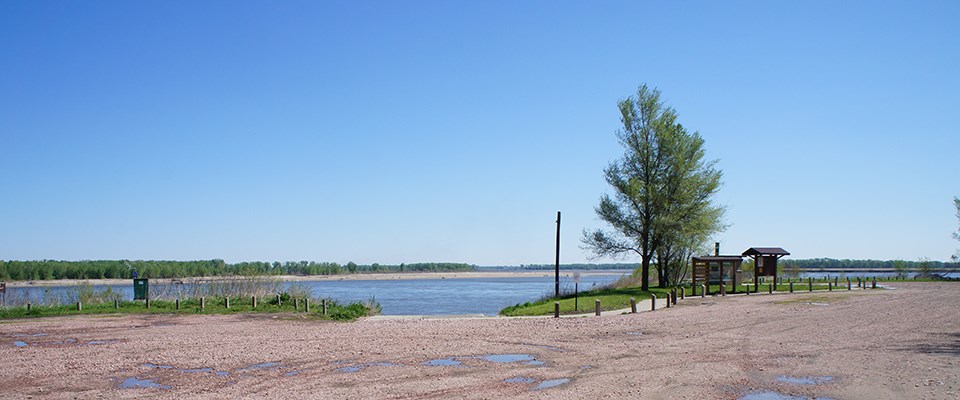
NPS photo Mulberry Bend Boat River Access (RM 775.0)Access to the river at Mulberry Bend is located downriver from the Vermillion-New Castle Bridge off County Road 579. A vault toilet is available and primitive camping only is allowed. To drive to this one-lane concrete boat ramp, take South Dakota Highway 19 south from Vermillion (it becomes Nebraska Highway 15 as soon as you cross the bridge) or Nebraska Highway 15 north toward Vermillion until you come to Road 579. Turn onto this gravel road and continue ahead 1.9 miles until you come to the boat ramp on your left. |
Last updated: September 24, 2024
