
NPS / Potter 
NPS / Gore The Snake River and its tributaries are iconic features of Grand Teton National Park. The river provides ecological habitat and recreation opportunities within the park, as well as water resources for communities downstream. The dynamic, shifting quality of the Snake River has left an imprint on the landscape. Elevation data allows park researchers to visualize this imprint. Below Jackson Lake Dam, the Snake River forms a braided river system, characterized by its interweaving, multi-threaded channels. Braided channels can form when a river has erodible banks, an abundance of coarse sediment, and rapid and frequent variations in streamflow. Coarse sediment, suspended in the water column during high flow, is deposited as the current wanes. Gravel bars begin to accumulate on the streambed, which finer sediments build on downstream. As water levels continue to drop, mid-channel bars surface. These bars shift with further erosion and deposition—processes that accelerate seasonally with subsequent streamflow fluctuations. The Snake River runs high in the late spring and early summer, fed by snowmelt. During this flooding season, the river fills a larger area, called the floodplain. Water submerges shallow bars and strong currents transport more sediment downstream. As the summer progresses and the water level drops, bars are re-exposed. The remaining stream flow meanders around the shifted sediment, cutting deeper channels, or braids, into the floodplain. Even on short time scales, the river’s braiding pattern will change as bars are continuously flooded and sediment is moved. However, some channels will remain and cut deeper year after year. Likewise, some bars endure even during the flood season, allowing vegetated islands to establish. The braiding of the Snake River provides a variety of habitats for park wildlife. 
NPS / Grubb Using LiDAR (Light Detection and Ranging) imagery—a mapping technique that measures reflection of light off the ground surface—researchers from Grand Teton’s Physical Science Program created a relative elevation model of the Snake River. A relative elevation model recalculates elevation of the ground using the water surface as a baseline, removing the elevation gradient from the river. The result is a stunning image that reveals landforms that cannot be seen from aerial images alone. Created by Madeline Grubb, this relative elevation model follows the Snake River from Jackson Lake to Moose, showing subtle changes in topography. The uneven riverbed, formed from centuries of erosion and deposition, reveals different paths the river has taken through time. Features such as old, abandoned channels, deep active channels, and floodplain extents are visible through the contrast of light and dark blues. With this map, the river's history can be traced. The map shows channel migration in multiple locations. For example, the river’s main path has shifted away from Schwabacher’s Landing. Mapping the braided channels has also allowed researchers to visualize geologic processes that guide the river. Near Deadmans Bar, the river converges into a single thread. This segment cuts through the terminal moraine of one of glaciers that carved Jackson Hole around 15,500 years ago. The terminal moraine is the accumulation of debris that forms at the edge of the glacier’s advance. The material left behind, which now makes up the riverbed in that area, is dense. So dense, researchers believe it constrained this portion of the river into one channel. The Snake River’s Wild and Scenic designation protects its natural dynamic from direct intervention. Even so, human activity influences the river’s fluvial character. Jackson Lake Dam regulates spring meltwater to extend irrigation supply into late summer. Standing 65 feet (20 meters) tall, the dam impounded the naturally formed Jackson Lake and increased the maximum water level by 38 feet (11.5 meters). Built in the early 1900s, its construction predates the Wild and Scenic River designation. Its operation has altered streamflow patterns. The extent of the dam’s impacts, and other influences on the river’s natural values, are still being explored. Understanding how past and present forces impact the Snake River helps inform future management decisions. For more information on how the Snake River is monitored, check out the annual Vital Signs reports. 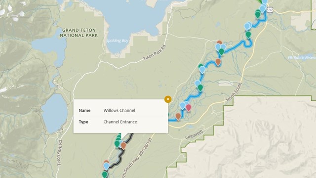
Advanced River Map
Map of known river features on the Snake River within the park. 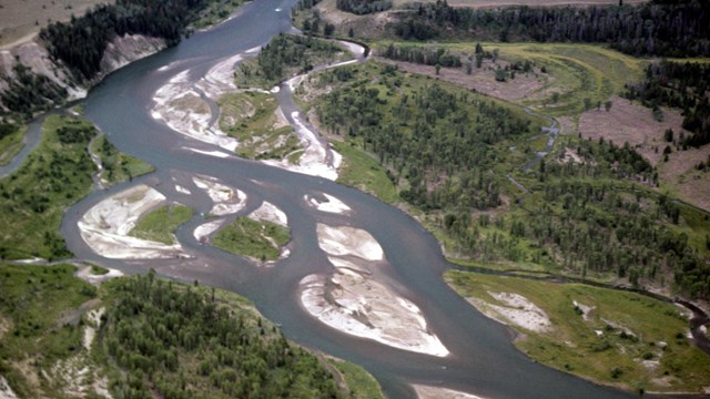
Hydrology
Rivers, lakes, and hot springs support the ecosystem |
Last updated: July 18, 2025