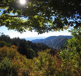
NPS Photo/Christine Hoyer In southern Appalachian vernacular, a gap is a low point in a mountain ridge. New Englanders call such places “notches” while westerners refer to them as mountain “passes.” At an elevation of 5,046 feet (1,538 m), Newfound Gap is the lowest drivable pass through the Great Smoky Mountains National Park. The old road over the Smoky Mountains crossed at Indian Gap, located about 1.5 miles (2.4 km) west of the current site. Newfound Gap's recognition as the lowest pass through the Great Smoky Mountains did not come until 1872. Arnold Henry Guyot, a Swiss geographer, measured many Southern Appalachian elevations. Mount Guyot, the second highest peak in the Smokies, takes his name. He used a simple barometer to measure changes in air pressure to calculate mountain heights. In most cases he was within 2 or 3 percent of current values. His work revealed Newfound Gap as the lowest pass through the mountains, displacing nearby Indian Gap. When the lower, easier crossing was discovered, it became known as the “newfound” gap. A new road followed, and it became the forerunner of Newfound Gap Road. A trip on Newfound Gap Road has often been compared to a drive from Georgia to Maine in terms of the variety of forest ecosystems one experiences. Starting from either Cherokee, North Carolina or Gatlinburg, Tennessee, travelers climb approximately 3,000 feet (914 m), ascending through cove hardwood, pine-oak, and northern hardwood forest to evergreen spruce-fir forest at Newfound Gap (5,046 feet/1,538 m). This fragrant evergreen woodland is similar to the boreal forests of New England and eastern Canada. At nearly a mile high, Newfound Gap is significantly cooler than the surrounding lowlands and receives much more snow. Temperatures at the gap may be 10°F or more cooler than in the lowlands. Precipitation falling as rain in Gatlinburg or Cherokee may be snow at Newfound Gap. On average, 69 inches (1.8 m) of snow falls at the gap each year. When there is snow on the ground, and the Newfound Gap Road has not been closed because of it, opportunities do exist for snow sports in the area. Many people use nearby Clingmans Dome Road (closed to vehicles December 1–March 31) for walking and cross-country skiing. The road starts a tenth of a mile south of Newfound Gap. Highlights:

Visit Great Smoky Mountains National Park's official online store for books, maps, and guides to the park. Operated by the nonprofit Smokies Life, proceeds generated by purchases at the store are donated to educational, scientific, and historical projects in the park. |
Last updated: May 30, 2024
