
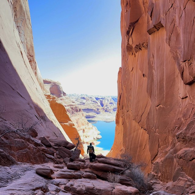
NPS Nestled in the heart of Escalante’s canyon country, Coyote Gulch contains two arches, a natural bridge, and several waterfalls. This concentration of outstanding natural features, relatively easy route finding and water availability make Coyote Gulch the most popular backpacking destination of all the canyons of the Escalante. To ensure this area of proposed wilderness remains a special place for future generations, please follow all regulations and plan accordingly. Thorough trip planning is not only your first step in having a safe and enjoyable trip, but also in protecting the natural and cultural resource in the area.When hiking in Coyote Gulch plan on encountering other visitors, particularly in the spring and fall. If solitude is one of your primary objectives, consider another route.
Trip PlanningBackcountry PermitsBackcountry permits are required for all overnight stays in the Escalante District of Glen Canyon National Recreation Area. Obtain permits at the Escalante Interagency Visitor Center in the town of Escalante or at one of the entry trailheads. Day use does not require a backcountry permit, but please sign the trail register. Group Size LimitLarge groups create large impacts in the backcountry. The group size limit for Coyote Gulch is 12 people. Groups larger than 12 people must break up into smaller groups and maintain a minimum distance of ½ mile from each other while hiking and camping. Group size limits are strictly enforced. Permits will be denied and violators will be cited if limits are exceeded. Leave No TraceMake every attempt to leave the backcountry nicer than you found it. “Take only pictures and leave only footprints” is a good reminder. Do not remove anything from the canyon. Leave the flowers, rocks and everything else for others to enjoy. Carry all of your trash out of the canyon, including toilet paper and other hygiene items. Do not burn or bury it. Human Waste DisposalHuman waste must be removed from Coyote Gulch. With the increase of recreational use, the National Park Service has introduced a human waste disposal program in the Escalante River corridor and its tributaries within Glen Canyon National Recreation Area. All human body waste solids shall be contained and carried out using a portable toilet or a specifically engineered bag waste containment system in Coyote Gulch. Use of a plastic or paper bag as a receptacle for solid human waste and/or for disposal of solid human waste is prohibited unless part of a specifically engineered bag waste containment system containing enzymes and polymers to treat human solid waste, capable of being sealed securely and state approved for disposal in ordinary trash receptacles. Visitors are responsible for providing their own removal system that is adequate for the size of their group and length of stay. There are many “portable toilet” human waste bags available on the market. Some examples are Restop II Bags, Wag Bags and Biffy Bags. These products can be found at many outdoor product retailers. Homemade PVC “poop tubes” or other hard sided screw top containers can be used directly or in conjunction with a bag system. FiresFires are not permitted in Coyote Gulch. PetsPets are not permitted in Coyote Gulch. This includes pack animals such as horses, llamas and goats. WildlifeDo not feed wildlife. Food and trash should be stored in a manner impervious to entry by birds and other wildlife. Rock CairnsDo not build rock cairns.They can mislead other visitors who rely on landmarks for wayfinding. Building them causes resource damage. Rely on your map and compass and know your route. Preserve the SoundscapeYour voice carries farther than you think in canyon country. Respect other visitors by keeping your group quiet and not playing amplified music. If you must have music in the backcountry wear headphones. Flash FloodsIn canyon country, always be Flash Flood Aware! Flash flooding can result from heavy rains and thunderstorms. Even if the skies above you are clear, a storm miles away can trigger a flash flood in your area. Check weather conditions before hiking, and especially before entering a slot canyon. Route DescriptionTrailheadsCoyote Gulch may be enjoyed as an overnight backpacking trip or as a long day hike. The mileage and length of time required will depend on your point of entry into the canyon. Please check road conditions before your trip to a trailhead.
Hiking Distances
Water AvailabilityCoyote Gulch contains a number of seeps and springs in addition to a perennial stream. One particularly good spring flows from the canyon wall just downstream from Jacob Hamblin Arch. Be Ready to Get WetThe perennial stream in Coyote Gulch begins about one mile from the Red Well trailhead. The stream in Hurricane Wash begins about 3.5 miles from the trailhead. The stream is encountered upon reaching the canyon bottom from the other two trailheads. Most of the hike includes many stream crossings or walking in the stream. Your feet will get wet. From Red Well or Hurricane Wash trailheads, the canyon develops from wide, sandy washes to a narrow canyon with towering walls as you travel toward the confluence with the Escalante River.
Visit our keyboard shortcuts docs for details
Step away from city life and explore the canyons of the Escalante on an overnight hike to Coyote Gulch. Glen Canyon is your National Recreation Area. Learn More
|

Last updated: May 4, 2026