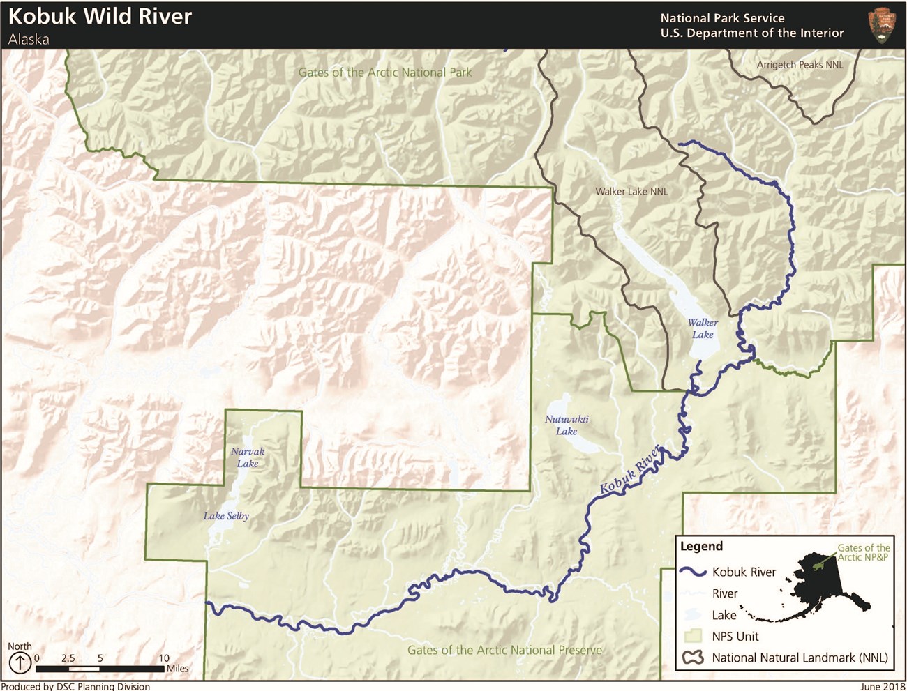
NPS/Josh Spice The 380-mile-long Kobuk River originates in the Endicott Mountains in the Brooks Range and flows west to Kotzebue Sound.Located on the southernmost reaches of the Brooks Range, the Kobuk River flows from its headwaters in the Endicott Mountains and Walker Lake, through a broad valley that is one of the largest continuous forested areas in the Park and Preserve. The Kobuk is an exceptional float river with many hiking opportunities in the upper reaches. There are a few short stretches of extremely rugged rapids in the stretch just below Walker Lake (up to class V). You’ll find good opportunities for sport hunting (in the preserve only), fishing, and wildlife observation. The river’s wide valley, exceptional rapids, and outstanding biota provide remarkable natural resources. 
Approximate Length110 mi / 177 km inside Gates of the Arctic National Park & Preserve Scenic QualityThe Kobuk River has a diverse range of scenery, from the dramatic headwaters at Walker Lake to the interior lowlands. Walker Lake, part of the headwaters of the Kobuk River, is the largest lake in the Brooks Range and is a national natural landmark. It is a picturesque, glacially carved lake that is surrounded by the dramatic topography for which the central Brooks Range is famous. Two canyons, the Upper Kobuk and the Lower Kobuk, provide visitors with unique scenic opportunities. Bluffs 100 to 200 feet tall exemplify the Upper Kobuk Canyon, while the Lower Kobuk Canyon is punctuated by large sandstone boulders and narrow canyon walls. Relatively low mountains and a notably wide valley surrounding the Kobuk provide views through a remarkable vista. Reduced spruce densities also allow unobstructed views of uniquely colored landforms adjacent to the river’s edge. Recreational OpportunitiesThe Kobuk River is the setting for an internationally renowned trophy sheefish sportfishery as well as a diverse, exciting float trip. The Kobuk is highly desirable among anglers for its sheefish fishery, particularly for its trophy sheefish, and accounts for more than half of northwestern Alaska’s sport sheefish harvest. Additionally, chum salmon, arctic grayling, and whitefish can be caught along portions of the Kobuk River. The Kobuk River provides exceptional opportunities for novice and experienced rafters alike. The highly variable surroundings of the remainder of the Kobuk corridor provide an interesting and ever-changing float experience as the river flows from Walker Lake and the Arctic mountains to lowland boreal forest. The river provides a range of unique conditions along 125 miles of floatable river, including Class I to Class V rapids. The outlet river from Walker Lake provides significant drops along a 1/3-mile stretch of Class V rapids that can present a challenging float trip. From below these rapids to the Kobuk River is a small section of Class II rapids that require maneuvering. Portions of the main Kobuk within the Lower Kobuk Canyon require greater skill and methodical maneuvering due to uniquely intensive conditions such as Class III-V rapids, strong currents, rocks, and large drops. Geologic FeaturesThe headwaters of the Kobuk River include Walker Lake, a Natural National Landmark, and downstream are a series of canyons made of near vertical sheets of shale. Walker Lake, a 12-mile-long lake located north of the Kobuk River, is in the National Register of Natural Landmarks. The Upper and Lower Kobuk Canyons, as well as the Endicott Mountains, are unique geologic features characterizing the Kobuk River region. Within the Lower Kobuk Canyon, bedrock covers the canyon floor with nearly vertical sheets of shale along the banks. Quartz and jasper or jade, in conjunction with shale, are also viewable. Natural ResourcesThe Kobuk River protects crucial spawning habitat for an important population of sheefish, as well as having a rich assemblage of fish species in general. The Kobuk River is one of only two major spawning grounds for the Kobuk/Selawik population of sheefish. The Kobuk is inhabited by relatively large sheefish, with individuals exceeding 40 pounds. Many other fish species also inhabit the Kobuk, including grayling, arctic char, whitefish, chum salmon, and lake trout. The Kobuk is a major chum salmon spawning ground, believed to support more than half of the Kotzebue District’s commercial chum salmon. Additionally, the Kobuk provides several Eskimo villages with subsistence fishing for sheefish, whitefish, and chum salmon, which spawn in the upper portion of the river. Variety of fish and wildlife; one of largest concentrations of sheefish; wintering grounds for Western Arctic caribou herd; one of the largest continuous spruce forest areas in the Brooks Range; Cultural ResourcesThe Kobuk River contains rich archeological resources that document the river’s role as a convergence zone for inland and coastal cultures. The Kobuk River contains an exceptionally rich record of past human activity that spans at least 10,000 years. Within Gates of the Arctic, the river corridor contains at least 172 historic and prehistoric archeological sites that represent Paleoarctic, Northern Archaic, Arctic Small Tool, Late Prehistoric, and Historic Periods. Site types include villages, camps, hunting overlooks, portages, and resourceextraction locations. The valley was a major east-west travel corridor connecting coastal areas around the Bering Strait to northern interior Alaska. These interactions are demonstrated by the frequent occurrence of obsidian, jade, and other exotic raw materials in ethnographic accounts and archeological sites on the Kobuk River. The river was a particularly important path of distribution for obsidian derived from a major source on the Koyukuk River some 150 miles to the southwest, and the only known source of jade in mainland Alaska. Hundreds of traditional place names carpet this landscape and attest to local residents’ detailed knowledge of and intimate relationship with the land and its resources. The Kobuk River was the site of a minor gold rush at the turn of the century. |
Last updated: May 7, 2020

