NPS Photo / Kent Miller
The road study was completed in 2012 with the approval of the Denali Park Road 2012 Vehicle Management Plan. This plan marks the start of a new era in the management of the park road.

Study HistoryIn 2006, Denali began a multidisciplinary study designed to optimize visitor experience along the park road while protecting wildlife. Since 1972, traffic on the park road has been limited mostly to buses, and since 1986, a use limit of 10,512 vehicle trips annually has been in effect. Faced with increasing visitation and pressure to defend or change the limits to road traffic, park managers have designed a study to develop a greater understanding of the impacts of traffic volume and traffic patterns on the physical, biological, and social environment of the park. The study was comprised of three primary components and took place from 2006 to 2012. Wildlife MovementsThe heat map below demonstrates the three bears (#s 573, 576 and 586) tracked in summer 2006. The fainter, bluer colors indicate areas infrequently visited by the bears, while the yellow and red (warmer) areas indicate areas where those bears spent more time.
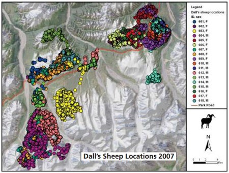
To examine potential impacts of Park Road traffic on wildlife movements and distribution, researchers deployed GPS collars on 20 Dall's sheep and 20 grizzly bears within the road corridor. Location information and movement paths of collared animals were modeled with habitat and traffic data to determine possible relationships between vehicles on the Park Road and wildlife behavior. Displaying thousands of points, the data demonstrate what parts of the park these animals frequent, and when. Visitor SurveyResearchers examined the expectations and quality of experiences of Denali Park Road vehicle users. As part of this study, visitors were asked to identify and describe issues important to their experience on the Denali Park Road. The results of these interviews were used to determine indicators and help set standards for visitor experience on the Park road. Park managers are using the indicators and standards to evaluate and manage vehicle. Traffic ModelTraffic patterns on the Denali Park road are unique and affected by predictable and unpredictable factors such as locations and type of wildlife sightings, numbers and type of buses on the road each day, weather, and road maintenance. Researchers used GPS and wildlife sighting data collected from vehicles driving the park road in 2006/2007 to create a traffic model to simulate the location and timing of vehicles on the park road. Study GoalsUltimately, a comprehensive model of park road traffic was developed to predict the effects of changes in traffic volume and timing on visitor experience and wildlife movements. The model results informed the selection of a preferred alternative presented in the Vehicle Management Plan Environmental Impact Statement (EIS). This model suggested that an increase in traffic volume was feasible. The next step is an experimental increase in road traffic, timed so as to produce the greatest value in understanding impacts, as part of a Before-After Condition-Change Assessment (BACCA) study. The goal of the road study was to provide park managers with a tool to make well-informed, science-based decisions about the future of traffic on the park road. Developing Indicators and StandardsResults from the road capacity study were used to select seven indicators of desired resource and visitor experience conditions. Three of the indicators restrict the amount and timing of vehicle traffic to protect wildlife:
Three indicators set limits on vehicle crowding based on results of the visitor surveys:
The final indicator reflects the effectiveness of the transportation system:
Results were also used to set quantitative standards for each indicator to ensure that desired conditions are maintained. Meeting the standards means success in managing the park road for its natural ecology and visitor experience. Download the Table of Indicators and Standards Additional Information |
Last updated: May 31, 2019
