News Release

NPS Map
|
Subscribe
|
Contact: Robinson Barker, 912 882 4336 x254
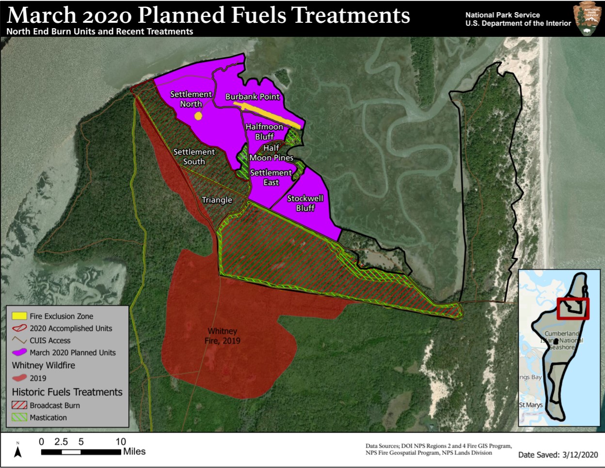
St. Marys, GA – Cumberland Island National Seashore is planning to implement prescribed burn operations in seven burn units on the north end of the island. The seven burn units are in the Settlement Area adjacent to the 2019 Whitney Fire and were previously burned in 2020.
The North End Burn Plan was developed in accordance with Cumberland Island’s 2015 Fire Management Plan to support the park’s structural protection plan for north end structures while allowing for natural fire to play its role in the wilderness area to its south.
The seven burn units total 413 acres consisting of longleaf pine, oak scrub, live oak, and palmettos. Cumberland Island Fire Management staff will be looking to target the following areas: Triangle, Settlement South, Settlement North, Burbank Point, Halfmoon Bluff, Halfmoon Pines, and Settlement East. Areas within and adjacent to the boundaries set for these units burned during the lightning caused Whitney Fire (July 2019) as well as prescribed fires (July 2019, January of 2020, March 2020).
The burn will employ prescribed fire to reduce hazardous fuels in the Wildland Urban Interface (WUI), protect structures and cultural resources adjacent to the burn unit, and to promote a healthy fire frequency in the longleaf pine and scrub oak systems.
Cumberland Island National Seashore will be working with its interagency partners to initiate the prescribed burn on January 19th, 2022 , conditions permitting. The date of the fire is determined by the appropriate weather conditions as indicated in the seashore’s burn plan prescription.
Disruptions to park operations and impacts from smoke are expected to be minimal. Expect Bunkley Trail and Terrapin Point Trail to be closed along with the Settlement Area. Access via vehicles will be turned around before The Wharf. The staff will make every effort to communicate with the visiting public during the burn plan implementation both at the park and through the park’s website and Facebook site.
Public safety is paramount. Cumberland Island National Seashore staff and its partners are working together to ensure a safe and successful burn event.
For up to date information on the prescribed burn visit www.nps.gov/cuis and monitor the park’s Facebook page at www.facebook.com/cumberlandislandnps.
Cumberland Island is the largest barrier island off the coast of Georgia,
encompassing more than 36,000 acres of maritime forests, salt marsh and beaches.
The island is also home to over 9,800 acres of congressionally designated wilderness.
The island’s natural and cultural resources provide a rich and diverse habitat for
wildlife and offer a glimpse into the long history of coastal Georgia. The seashore is
accessible by pedestrian-only passenger ferry from the historic community of St.
Marys.
About the National Park Service. More than 20,000 National Park Service employees
care for America's 409 national parks and work with communities across the nation to
help preserve local history and create close-to-home recreational opportunities. Visit us
at www.nps.gov, on Facebook www.facebook.com/nationalparkservice.
Last updated: January 21, 2022
