Drawing The Boundary

Map of United States and Mexico depicting territory annexed by the United States and ceded by Mexico as a result of Mexican War for Independence, US-Mexican War, and the Gadsden Purchase. Land lost by Mexico is about half of its of its original territory.
The 1848 Treaty of Guadalupe Hidalgo ended the war and defined the Rio Grande as part of the new boundary between countries. Over the next several years, the United States and Mexico cooperated on surveying, marking, and mapping.

NPS / 106 GROUP


With US troops occupying Mexico City, the Mexican government agreed to surrender half of its national territory to the United States. Treaty negotiators had to redraw the line between their countries. For half of the nearly 2,000-mile boundary, they drew it from the Gulf of Mexico to El Paso along the Rio Grande. Thus, a free-flowing river became an international boundary. As the river changed course, would the treaty hold?

 
A hand-drawn, black-and-white map with the international boundary between the United States and Mexico depicted by a red line from the Pacific Ocean to the Gulf of Mexico.

UNIVERSITY OF TEXAS AT EL PASO LIBRARY
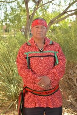
 
Man wearing a wide, red, patterned headband; a red, patterned shirt with green and black ribbons across his chest; and a red, black, and green patterned sash around his waist.
Javier Loera, War Captain, Ysleta del Sur Pueblo Tribal Council

NPS / BRIAN KANOF


“But to me it’s just a geopolitical division among these two relatively new nations.... It’s just a political barrier that divides two sides of the earth that have always been here."
—Javier Loera


Learn More About the US-Mexico Border

Loading results...

    Last updated: December 16, 2021

    Park footer

    Contact Info

    Mailing Address:

    800 South San Marcial Street
    El Paso, TX 79905

    Phone:

    915-532-7273

    Contact Us