
The Wagner Perspective South Pass - Fremont County, Wyoming South Pass was perhaps the most important landmark along the emigrant trails. It marked the end of the long ascent to the Continental Divide and the emigrants' arrival at the frontier of the Oregon country. It was also thought to be the halfway point along the trail. South Pass dictated the location of the emigrant trail, for only via its gradual ascent was wagon travel over the Continental Divide practical for large-scale emigration. South Pass is the wide, flat summit of a long and gradually ascending plateau, with low ridges and hills on both sides and a wide sage and grass-covered saddle between. Many emigrants commented that they scarcely noticed the ascent or the crossing. On July 12, 1846, Edwin Bryant made his way "up a very gentle ascent to the SOUTH PASS OF THE ROCKY MOUNTAINS, or the dividing ridge separating the waters of the Atlantic and the Pacific. The ascent to the Pass is so gradual, that but for our geographical knowledge . . . we should not have been conscious that we had ascended to, and were standing upon the summit of the Rocky Mountains-the backbone . . . of the North American Continent." For info on visiting South Pass, contact: Bureau of Land Management 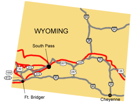
NPS Image |
Last updated: April 23, 2025