Directions

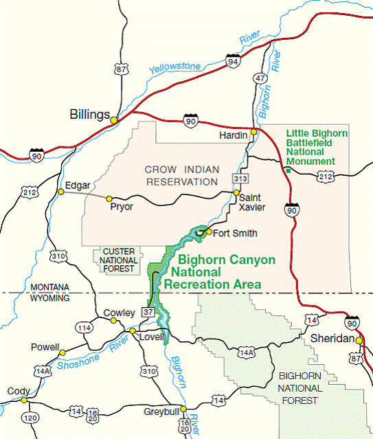
road map showing the location of Bighorn Canyon National Recreation area and two visitor service centers at north and south ends
This park is separated into two districts which are not directly connected. Driving time between the districts is approximately three hours. Please note the great opportunities each district has to offer and plan your trip accordingly.

The North District in Fort Smith, MT is mostly water based recreation and includes:
- Yellowtail Dam Visitor Center (Open Memorial Day to Labor Day)
- Park Headquarters
- Ok-A-Beh Marina (Open Memorial Day to Labor Day)
- Afterbay Reservoir, Boat Launch, and Campgrounds
- Three Mile River Access

The South District in Lovell, WY is largely land based recreation and includes:
- Cal Taggart Visitor Center (Open year round)
- Horseshoe Bend Marina (Open Memorial Day to Labor Day)
- Devil Canyon Overlook
- Pryor Mountain Wild Horse Range
- 12 hiking trails
- Four historic ranches open to self tours
- Horseshoe Bend, Barry's, and Trail Creek Campgrounds


Driving Directions to North District - Fort Smith, Montana

Contact 307-548-5406 if you need additional help.

From Billings, Montana:

  • Take Interstate 90 south for 43 miles to Hardin, Montana.
  • Turn off at exit 495 onto State Highway 313.
  • Take State Highway 313 south 22 miles to St. Xavier.
  • Turn left at St. Xavier to stay on State Highway 313, then travel 19 miles south to Fort Smith, Montana.
  • Drive through the community of Fort Smith. You will then see a sign that gives directions to several areas of the park.
  • During the summer, drive up to the Yellowtail Dam Visitor Center.
  • Distance: 95 miles

From Sheridan, Wyoming:

  • Take Interstate 90 north 70 miles to Crow Agency, Montana.
  • Turn off at exit 509.
  • At the exit ramp take a left and go under the highway overpass. Veer right onto BIA 1 (Crow-St. Xavier Road)
  • Take BIA 1 west for 20 miles
  • Take a left onto State Highway 313, then travel 19 miles south to Fort Smith, Montana.
  • Drive through the community of Fort Smith. You will then see a sign that gives directions to several areas of the park.
  • During the summer, drive up to the Yellowtail Dam Visitor Center.
  • Distance: 110 miles

From Little Bighorn Battlefield:

  • From the battlefield, take I-90 west to Hardin, MT.
  • Turn off at the Highway 313 exit to Ft. Smith, MT.
  • Drive through the community of Fort Smith. You will then see a sign that gives directions to several areas of the park.
  • During the summer, drive up to the Yellowtail Dam Visitor Center.
  • Distance: 47 miles

Driving Directions to South District - Lovell, Wyoming

From Billings, Montana:

  • Take Interstate 90 west for 12 miles.
  • Turn off at exit 434 for Laurel/Red Lodge, Montana.
  • At the exit ramp take a left onto US 310 East/US 212 South. Follow this highway for the next 12 miles.
  • Turn left at US 310 East and follow the highway for 63 miles to Lovell, Wyoming.
  • Once in Lovell continue all the way through town then take a left onto US 14 East.
  • The Bighorn Canyon Visitor Center will be 0.2 miles on your right. You can get a map at the visitor center.
  • Distance: 90 miles

From Sheridan, Wyoming:

  • Take Interstate 90 north for 12 miles.
  • Turn off at exit 9 for Ranchester-Dayton/Greybull-Lovell
  • Take a left onto US 14 West and follow this highway for 33 miles.
  • At Burgess Junction turn right at US 14 West and follow this highway for 52 miles.
  • The Bighorn Canyon Visitor Center is on your left, on the outskirts of Lovell, Wyoming. You can get a map at the visitor center.
  • Distance: 100 miles

From Cody, Wyoming:

  • Take US Alt 14 East for 44 miles.
  • Turn right on US 310 East for 3 miles onto Lovell, Wyoming.
  • Once in Lovell continue all the way through town then take a left onto US 14 East.
  • The Bighorn Canyon Visitor Center will be 0.2 miles on your right. You can get a map at the visitor center.
  • Distance: 47 miles

From Little Bighorn Battlefield (over the mountains):

  • From the battlefield, take I-90 going east into Wyoming.
  • Take exit 9 at Ranchester, WY to Highway 14.
  • Follow Highway 14 west over the Bighorn Mountains to 14A towards Lovell, WY. (14A is closed during the Winter in which case you need to take 14 to Greybull, then take 310 north to Lovell).
  • As you are driving west on 14A, turn right on Highway 37. The park entrance is 10 miles up Highway 37.
  • From November to May, 14A is closed for the winter. You will need to take Highway 14 to Greybull, WY, and then take Highway 310 north to Lovell.

From Little Bighorn Battlefield (through Billings):

  • You can reach the South District by taking I-90 west to Laurel, MT, and taking the Highway 310 exit at Laurel all the way to Lovell, WY. Highway 37 is two miles east of Lovell. Driving time is about 3 hours. You can get a map in Lovell at the visitor center.

Plane

Logan International Airport in Billings, Montana for either North or South District. Approximately one and one half hour to either district.

Yellowstone Regional Airport in Cody, Wyoming for South District. Approximately one hour driving time from airport.

Private Planes - The 5U7 airstrip in Fort Smith, Montana is unattended and a day use VFR airstrip. There are mountains and power lines surrounding the airstrip. It is suggested that with winds permitting take off should be done on Runway 07 and landings on Runway 25.

Public Transportation

None available.

Last updated: June 3, 2022

Park footer

Contact Info

Mailing Address:

Bighorn Canyon National Recreation Area South District Visitor Center
20 US Hwy 14A

Lovell, WY 82431

Phone:

307 548-5406
(307) 548-5406 is the South District in Lovell, WY. (406) 666-9961 is the North District in Fort Smith, MT.

Contact Us