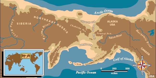
The Pleistocene Epoch, or more commonly known as the Ice Age, began about 1.75 million years ago and ended just ten thousand years ago. While the name may suggest it was a time of endless winter for the Earth, the truth is much different. The Earth’s climate experienced fluctuations of warm and cool temperatures. Sometimes these warm or cool periods lasted thousands of years. Towards the end of the Ice Age, the Earth experienced prolonged frigid conditions. In the northern region of the Earth, glaciers began to form. As more and more of the Earth’s water got locked up in glaciers, sea levels began to drop. In some areas it dropped up to 300 feet. The land beneath the Bering Strait became exposed and a flat grassy treeless plain emerged connecting Asia to North America. This exposed land stretched one thousand miles from north to south. As the ice age ended and the Earth began to warm, glaciers melted and sea level rose. Beringia became submerged, but not all the way. The Diomede Islands, the Pribilof Islands of St. Paul and St George, and St. Lawrence and King Island still poke out of the water. When exposed, the land bridge was vital for the transfusion of life between Asia and North America. The grasses, mosses and lichen that grew on the land bridge supported the herbivores that, in turn, supported the predators that preyed upon them. Slowly, plant and animal species began to inadvertently migrate from one continent into the other. People came too – following the movement of plants and animals – and remained! People on both sides of the Bering Strait are united by language, kinship, tradition, and dependence on their environment. Established as a national monument in 1978 and then deemed a national preserve in 1980, Bering Land Bridge National Preserve protects a piece of this ancient crossroad that is vital to the understanding of earth and human history. Its wild landscapes and unique landforms contain invaluable records of flora, fauna, and human migration between Asia and North America. |
Last updated: June 21, 2023
