Last updated: July 16, 2024
Article
NPS Geodiversity Atlas—San Juan Island National Historical Park, Washington
Geodiversity refers to the full variety of natural geologic (rocks, minerals, sediments, fossils, landforms, and physical processes) and soil resources and processes that occur in the park. A product of the Geologic Resources Inventory, the NPS Geodiversity Atlas delivers information in support of education, Geoconservation, and integrated management of living (biotic) and non-living (abiotic) components of the ecosystem.

Introduction
San Juan Island National Historical Park is located on San Juan Island, the second largest island in the San Juan Archipelago in San Juan County, Washington. Authorized as an NPS unit on September 9, 1966, San Juan Island preserves approximately 868 hectares (2,146 acres) that include more than 10 km (6 mi) of shoreline, trails, prairies, and military camps. It was established to protect and interpret the sites of the American and English Camps and to commemorate the peaceful settlement of the San Juan Boundary Dispute between Great Britain and the United States from 1853 to 1872, including the Pig War crisis of 1859. The historical park is composed of two units, the American Camp (the larger of the two park units) located at the southern end of San Juan Island and the English Camp located at the northern end of the island. American Camp was the location of the U.S. Army camp during the 12-year joint occupation of the island, while English Camp was the location of a British Royal Marines camp. Both camps were established in 1859 in response to a border dispute triggered by the killing of a pig, an event that almost sparked a war between Britain and the United States. In 1872, the boundary dispute was settled when Kaiser Wilhelm I of Germany awarded the San Juan Islands to the United States. San Juan Island National Historical Park illustrates how war can be averted and peace maintained through positive action by individuals and governments.
Geologic Setting
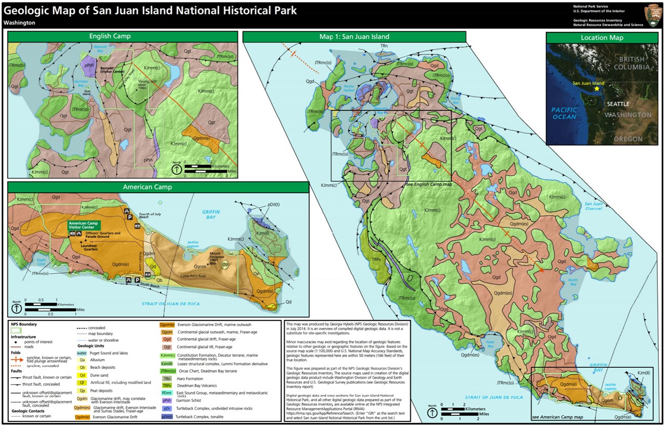
The geology of San Juan Island National Historical Park has been dramatically influenced by dynamic earth processes that include plate tectonic collision, ice-age glaciation, and modern coastline processes. Within San Juan Island are Paleozoic and Mesozoic rock units (Garrison Schist, Decatur Terrane, and Deadman Bay Terrane) that record thrust faulting and metamorphism resulting from the tectonic collision between the North American and Farallon Plates during the Cretaceous approximately 84–100 Ma. The convergence of these two plates deformed, juxtaposed, and transported masses of bedrock about 2,500 km (1,600 mi) north along the western coast of North America. Pleistocene-age glaciers covered the landscape of San Juan Island approximately 17,000 years ago, carving and rounding the more resistant bedrock of the region. As the glaciers melted and receded, they left behind poorly-sorted, unconsolidated deposits of gravel, sand, and silt. With the tremendous weight of ice and snow removed, the landscape of San Juan Island began to slowly rise in a process known as isostacy, creating exceptionally well-developed terraces out of former beaches. Since the end of the Pleistocene ice ages, coastal processes such as onshore winds, tides, rip currents, and longshore currents have continued to modify the shoreline of San Juan Island.
Regional Geology
San Juan Island National Historical Park is a part of the Pacific Border Physiographic Province and shares its geologic history and some characteristic geologic formations with a region that extends well beyond park boundaries.
- Scoping summaries are records of scoping meetings where NPS staff and local geologists determined the park’s geologic mapping plan and what content should be included in the report.
- Digital geologic maps include files for viewing in GIS software, a guide to using the data, and a document with ancillary map information. Newer products also include data viewable in Google Earth and online map services.
- Reports use the maps to discuss the park’s setting and significance, notable geologic features and processes, geologic resource management issues, and geologic history.
- Posters are a static view of the GIS data in PDF format. Newer posters include aerial imagery or shaded relief and other park information. They are also included with the reports.
- Projects list basic information about the program and all products available for a park.
Source: NPS DataStore Saved Search 3166. To search for additional information, visit the NPS DataStore.
A NPS Soil Resources Inventory project has been completed for San Juan Island National Historical Park and can be found on the NPS Data Store.
Source: NPS DataStore Saved Search 3117. To search for additional information, visit the NPS DataStore.
GRI Geology Image Gallery

Related Links
Related Articles
San Juan Island National Historical ParkNational Park Service Geodiversity Atlas
The servicewide Geodiversity Atlas provides information on geoheritage and geodiversity resources and values within the National Park System. This information supports science-based geoconservation and interpretation in the NPS, as well as STEM education in schools, museums, and field camps. The NPS Geologic Resources Division and many parks work with National and International geoconservation communities to ensure that NPS abiotic resources are managed using the highest standards and best practices available.

