Last updated: July 11, 2024
Article
NPS Geodiversity Atlas—National Park of American Samoa, American Samoa
Geodiversity refers to the full variety of natural geologic (rocks, minerals, sediments, fossils, landforms, and physical processes) and soil resources and processes that occur in the park. A product of the Geologic Resources Inventory, the NPS Geodiversity Atlas delivers information in support of education, Geoconservation, and integrated management of living (biotic) and non-living (abiotic) components of the ecosystem.

Introduction
The National Park of American Samoa (NPSA) is located in the South Pacific more than 4,200 km (2,600 mi) southwest of Hawai‘i and is the only National Park Service unit in the southern Hemisphere. Authorized on October 31, 1988, the land base of NPSA was established in September 1993 when a 50-year lease agreement was signed between the American Samoa Government and the National Park Service. NPSA encompasses approximately 3,341 hectares (8,257 acres) and was established to preserve, protect, and interpret paleotropical rainforests, coral reef ecosystems, and Samoan cultural traditions and resources that date back 3,000 years. The park is distributed among three remote volcanic islands (of seven in American Samoa) that include Taʻū, Ofu, and Tutuila. These three separate islands contain lush rainforests, cloud forests, littoral forests, diverse coral communities, lagoons, wetlands, and beaches (Thornberry-Ehrlich 2008).
Geologic Setting
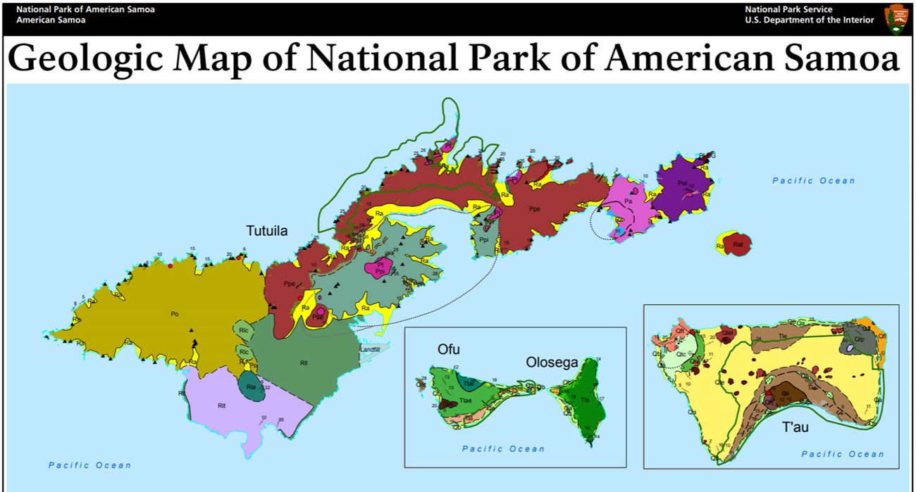
The islands of American Samoa are a series of broad shield volcanoes that rise thousands of meters or feet above the Pacific Ocean floor and consist of alternating lava flows and pyroclastic debris that hardened into tuff, volcanic breccia, lapilli, and cinder layers (Thornberry-Ehrlich 2008). The Ofu Island unit of NPSA contains some of the oldest exposures in the park, represented by volcanic breccias and plugs of the Pliocene Asaga Formation). Younger Pleistocene and Holocene sedimentary rocks consisting of calcareous sediments and alluvium are also mapped within the Ofu Island unit. The Taʻū Island unit of NPSA consists of volcanic units of the Pleistocene Lata Formation that are subdivided into intra-caldera flows and post-caldera volcanics. Ponded lavas and pāhoehoe flows of the Pleistocene Luatele Formation and lava flows of the Holocene Fitiʻuta Formation are located within the park boundaries on the northeastern portion of Taʻū Island. The Tutuila Island unit of NPSA is composed of volcanic rocks of the Pliocene– Pleistocene Pago Volcanics, trachyte pumice deposits, plugs, and dikes, as well as younger Holocene deposits consisting of calcareous sand, talus, and alluvium.
- Scoping summaries are records of scoping meetings where NPS staff and local geologists determined the park’s geologic mapping plan and what content should be included in the report.
- Digital geologic maps include files for viewing in GIS software, a guide to using the data, and a document with ancillary map information. Newer products also include data viewable in Google Earth and online map services.
- Reports use the maps to discuss the park’s setting and significance, notable geologic features and processes, geologic resource management issues, and geologic history.
- Posters are a static view of the GIS data in PDF format. Newer posters include aerial imagery or shaded relief and other park information. They are also included with the reports.
- Projects list basic information about the program and all products available for a park.
Source: NPS DataStore Saved Search 3027. To search for additional information, visit the NPS DataStore.
A NPS Soil Resources Inventory project has been completed for National Park of American Samoa and can be found on the NPS Data Store.
Source: NPS DataStore Saved Search 3074. To search for additional information, visit the NPS DataStore.

Related Links
Related Articles
National Park of American Samoa
National Park Service Geodiversity Atlas
The servicewide Geodiversity Atlas provides information on geoheritage and geodiversity resources and values within the National Park System. This information supports science-based geoconservation and interpretation in the NPS, as well as STEM education in schools, museums, and field camps. The NPS Geologic Resources Division and many parks work with National and International geoconservation communities to ensure that NPS abiotic resources are managed using the highest standards and best practices available.

