Last updated: July 8, 2024
Article
NPS Geodiversity Atlas—Indiana Dunes National Park, Indiana
Geodiversity refers to the full variety of natural geologic (rocks, minerals, sediments, fossils, landforms, and physical processes) and soil resources and processes that occur in the park. A product of the Geologic Resources Inventory, the NPS Geodiversity Atlas delivers information in support of education, Geoconservation, and integrated management of living (biotic) and non-living (abiotic) components of the ecosystem.

Introduction
Indiana Dunes National Park is located along the southern shore of Lake Michigan in Lake, La Porte, and Porter Counties, Indiana. It was authorized on November 5, 1966, as a national lakeshore and redesignated a national park on February 15, 2019. INDU encompasses approximately 6,210 hectares (15,347 acres) of beaches, dunes, bogs, oak savannas, marshes, swamps, prairie remnants, rivers, and forests (Anderson 2017). The park was established to preserve the lake front, Indiana Dunes, and other areas of scenic, scientific, and historic interest from encroaching urban development. The park contains 24 km (15 mi) of shoreline with sand dunes that rise from the shores of Lake Michigan. The boundaries of INDU are spread across several units, including one national historic landmark (Joseph Bailly Homestead), four national natural landmarks (Pinhook Bog, Cowles Bog, Dunes Nature Preserve, and Hoosier Prairie), and the Heron Rookery area and trail (Thornberry-Ehrlich 2020).
Geologic Setting
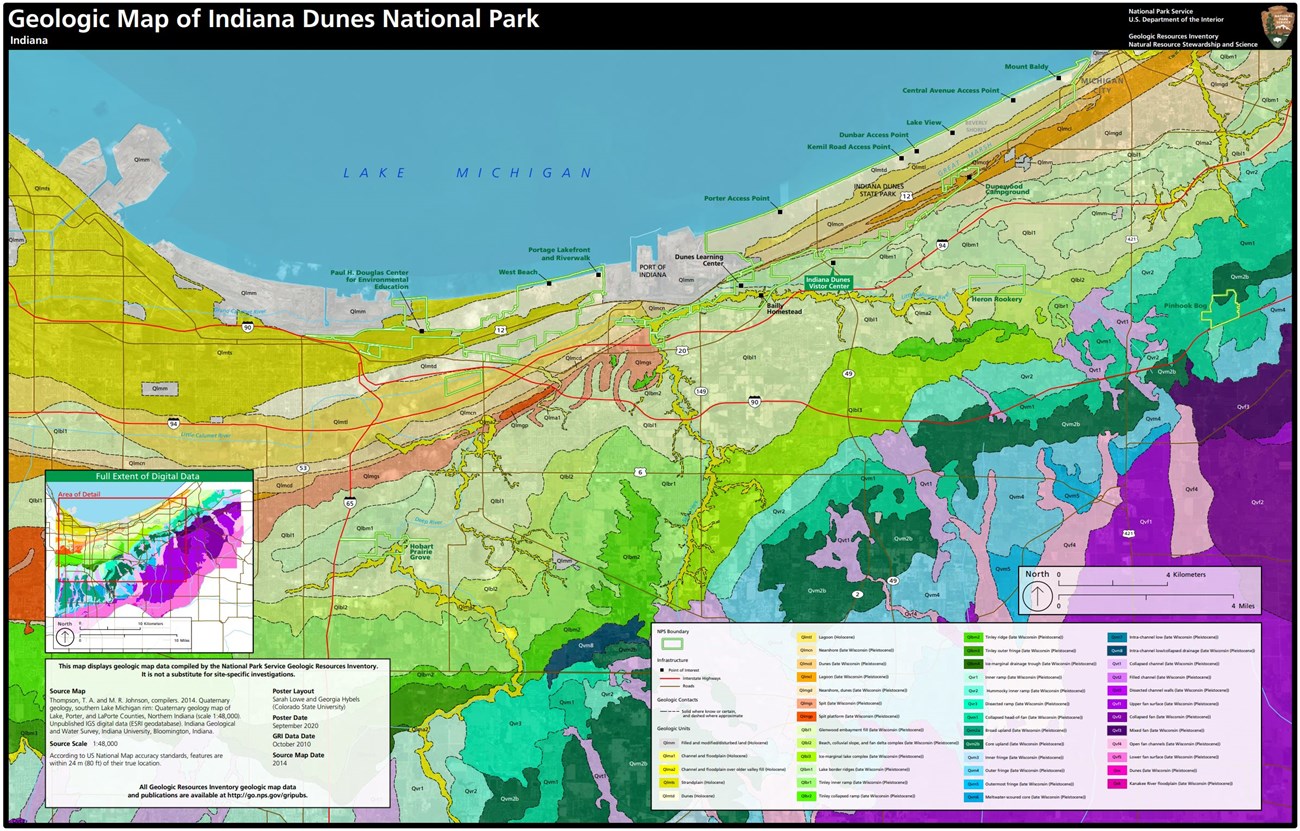
The geology of Indiana Dunes National Park has been influenced by multiple advances and retreats of the Laurentide ice sheet and by fluctuating levels and extents of the Great Lakes. Relic shorelines are preserved at INDU and record relative lake-level changes in Lake Michigan through geologic time. Three major coastal geomorphic features are found in the park and correlate to Lake Michigan highstands (interval of time when relative lake-level is elevated for a given area): the Glenwood, Calumet, and Tolleston beaches (Capps et al. 2007; Thornberry-Ehrlich 2020). The Laurentide ice sheet eroded preexisting Paleozoic bedrock. Buried beneath INDU are the Silurian Wabash Formation, Devonian Muscatatuck Group, Late Devonian Antrim Shale, and Devonian–Mississippian New Albany Shale (Thornberry-Ehrlich 2020). As the ice age glaciers intermittently waxed and waned throughout the Pleistocene Epoch, they deposited sediment across the landscape. Mapped units at INDU are geologically recent and consist of Pleistocene and younger deposits associated with beaches, fan deltas, spits, dunes, lagoons, strandplains, channels, and floodplains.
Geologic Features and Processes
Features visible within the park, all within about 50 miles of Chicago and surrounded by myriad of industrial, urban, suburban, and rural settings, include the following:
-
Coastal/lacustrine features and processes
-
Eolian features and processes
-
Fluvial features and processes
-
Glacial features and processes
-
Paleontological resources
Geoconservation
Those varied geologic features and processes also create a multitude of resource management issues for park staff, including:
-
Shoreline erosion
-
Disturbed lands
- Geologic hazards: slope movements, sand collapses, and earthquakes
Learn more about NPS programs for geologic resource management on these websites: [Geoconservation Programs] [Geohazards] [Fossil Stewardship] [Cave Resources Stewardship]
Regional Geology
Indiana Dunes National Park is a part of the Central Lowland Physiographic Province and shares its geologic history and some characteristic geologic formations with a region that extends well beyond park boundaries.
- Scoping summaries are records of scoping meetings where NPS staff and local geologists determined the park’s geologic mapping plan and what content should be included in the report.
- Digital geologic maps include files for viewing in GIS software, a guide to using the data, and a document with ancillary map information. Newer products also include data viewable in Google Earth and online map services.
- Reports use the maps to discuss the park’s setting and significance, notable geologic features and processes, geologic resource management issues, and geologic history.
- Posters are a static view of the GIS data in PDF format. Newer posters include aerial imagery or shaded relief and other park information. They are also included with the reports.
- Projects list basic information about the program and all products available for a park.
Source: NPS DataStore Saved Search 2905. To search for additional information, visit the NPS DataStore.
A NPS Soil Resources Inventory project has been completed for Indiana Dunes National Park and can be found on the NPS Data Store.
Source: NPS DataStore Saved Search 2977. To search for additional information, visit the NPS DataStore.
GRI Geology Image Gallery
Related Articles
Indiana Dunes National Park
National Park Service Geodiversity Atlas
The servicewide Geodiversity Atlas provides information on geoheritage and geodiversity resources and values within the National Park System. This information supports science-based geoconservation and interpretation in the NPS, as well as STEM education in schools, museums, and field camps. The NPS Geologic Resources Division and many parks work with National and International geoconservation communities to ensure that NPS abiotic resources are managed using the highest standards and best practices available.


