Last updated: January 14, 2025
Article
NPS Geodiversity Atlas—Fort Davis National Historic Site, Texas
Geodiversity refers to the full variety of natural geologic (rocks, minerals, sediments, fossils, landforms, and physical processes) and soil resources and processes that occur in the park. A product of the Geologic Resources Inventory, the NPS Geodiversity Atlas delivers information in support of education, Geoconservation, and integrated management of living (biotic) and non-living (abiotic) components of the ecosystem.

Introduction
Fort Davis National Historic Site preserves one of the largest and most intact examples of a post-Civil War frontier fort in the American Southwest. The fort is located on the eastern side of the Davis Mountains which are a sky island in the Trans-Pecos region of West Texas.
The Davis Mountains have higher elevations and a cooler, wetter environment than the surrounding Chihuahuan Desert. The Davis Mountains are also the largest mountain range located entirely within Texas, with elevations reaching nearly 8,400 feet. They were formed by volcanic activity over a three-million year period ending approximately 35 million years ago.
Fort Davis is located at the mouth of Hospital Canyon, a dry box canyon near Limpia Creek, in an area where wood, water, and grass were plentiful. Limpia Creek flows just outside of the northern park boundary, and Davis Mountains State Park borders the historic site to the northwest. The historic site encompasses 523 acres (212 hectares), with elevations ranging from approximately 4,830 feet (1,470 m) to 5,355 feet (1,630 m). The fort itself sits on alluvial fan deposits beneath the rugged cliffs of Sleeping Lion Mountain and North Ridge, which are both made up of rhyolites.

Geologic Setting
The Davis Mountains Volcanic Field is located within the larger Trans-Pecos Magmatic Province. Volcanism occurred in the Trans-Pecos Texas region from 47 million years ago to about 17 million years ago. The earlier Trans-Pecos volcanism was mostly located to the south of the Davis Mountains in Big Bend National Park.
Volcanism in the Davis Mountains Volcanic Field mostly occurred between 37 and 35 million years ago during the main phase of activity in the region. The main types of volcanic deposits found in the Davis Mountains consist of flood rhyolites and large volume ash-flow tuffs.
Flood rhyolites are large volume rhyolitic lava flows that cover a wide geographic area. They are relatively rare in the geologic record.
Large volume ash-flow tuffs are produced during caldera-forming eruptions. Calderas are collapse structures that form during exceptionally large volume volcanic eruptions that partially empty the underlying magma chamber causing the ground above it to subside. Four caldera complexes have been identified in the Davis Mountains.
The volcanic rocks exposed in the Davis Mountains mostly have silicic compositions similar to dacite and rhyolite. But many of these volcanic rocks have unique chemical characteristics. They have high concentrations of potassium and sodium (specifically, they are described as being per-alkaline). This is significant because rhyolites with especially high concentrations of these elements are not nearly as viscous than most rhyolites. Viscous lavas are “sticky” meaning that they have a high resistance to flow and typically form lava domes instead of dispersed flows. The chemistry of these lavas was surely a factor in development of the flood rhyolites of the Davis Mountains.
Rhyolites with these high concentrations of potassium and sodium also have high eruption temperatures. Ash-flow tuffs made of per-alkaline rhyolite can be so hot when they are deposited that they can experience ductile flow. This secondary flowage is known as rheomorphism. It can be very difficult for geologists to distinguish between rheomorphic ash-flow tuffs and silicic lava flows because they may look very much alike. Hence it is not clear whether some of the rhyolites in the Davis Mountains and in Fort Davis National Monument were emplaced as lava flows or ash-flow tuffs.
Related Links
Regional Geology
Fort Davis National Historic Site is a part of the Basin and Range Physiographic Province and shares its geologic history and some characteristic geologic formations with a region that extends well beyond park boundaries.
Geologic Features and Processes
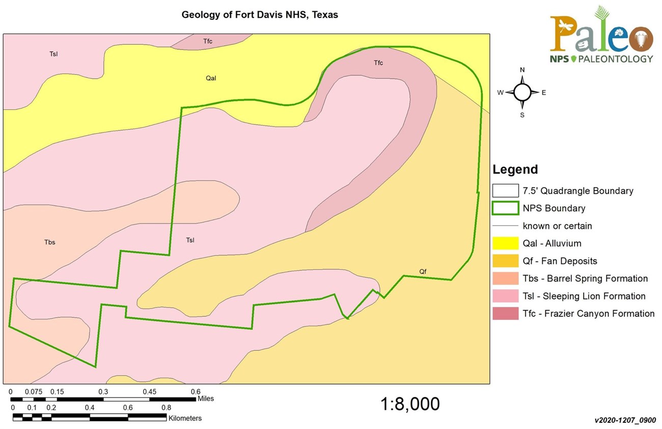
Three volcanic rock units are exposed in Fort Davis National Historic Site: The Frazier Canyon Formation, the Sleeping Lion Formation, and the Barrel Springs Formation.

NPS image.
The Sleeping Lion Formation is the main rock unit exposed in Fort Davis National Historic Site. Sleeping Lion Mountain just south of the fort is made up of this rock unit. North Ridge above the fort is also mostly made up of the Sleeping Lion Formation, but the Frazier Canyon Formation is exposed on the lower slopes. The Barrel Springs Formation is exposed at the highest elevations of North Ridge and is also exposed in the adjacent Davis Mountains State Park.
Frazier Canyon Formation
The Frazier Canyon Formation consists of tuffaceous sediments and mafic (a composition that is high in magnesium and iron and low in silica) lava flows. It is older than 36.5 million years old.
It is exposed at the base of North Ridge with a thickness of approximately 120 ft (37 m).
Sleeping Lion Formation
The Sleeping Lion Formation is the most prominent rock unit in Fort Davis National Historic Site. It was named after Sleeping Lion Mountain, but a formal stratotype for this unit has not been designated.
The Sleeping Lion Formation consists of low-silica peralkaline rhyolite with feldspar and other crystals in a glassy groundmass. It was erupted about 36.5 million years ago west of Fort Davis and flowed down paleovalleys towards the east. The origin of the Sleeping Lion Formation is enigmatic as it contains features that appear characteristic of both ash-flow tuffs and lava flows. It contains textures that look like the glass shards found in ash-flow tuff deposits and also basal breccias that form in lava flows.
The Sleeping Lion Formation is approximately 200 feet (60 m) in the historic site with prominent columnar jointing.
Barrel Springs Formation
The Barrel Springs Formation makes up the upper part of North Ridge including in the neighboring Davis Mountains State Park, where it is about 260 feet (80 m) thick.
The name Barrel Springs Formation has been widely applied to both lava flows and ash-flow tuffs in the Davis Mountains and there are some discrepancies in the use of the nomenclature for this unit. It contains several units of lava flows and/or strongly rheomorphic ash-flow tuffs.
In Fort Davis National Historic Site, the Barrel Springs consists of a rhoemorphic ash-flow tuff at the base of the unit with overlying rhyolite lava flows.
Some researchers have elevated the Barrel Springs Formation to a group and named the lower ash-flow tuff the Fort Davis Tuff based on outcrops in Davis Mountains State Park. The Fort Davis Tuff erupted 36.2 million years ago from the Paradise Mountain Caldera.
Geodiversity Values
Palisades (Columnar Jointing)
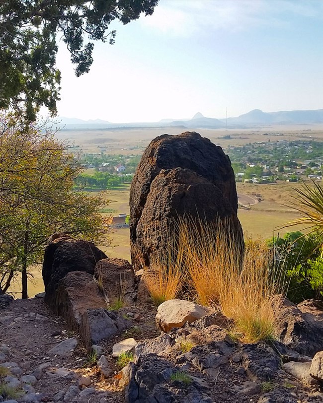
Columnar jointing in the Sleeping Lion Formation on both North Ridge and Sleeping Lion Mountain make the cliffs above Fort Davis to appear like a palisades. Columnar jointing forms during cooling of some lava flows and ash-flow tuffs. It consists of sets of regularly spaced parallel fractures (joints) that intersect one another in a prismatic pattern. The columnar joints at Fort Davis are more irregular than the nearly perfect columns at some sites, such as Devils Postpile and Devils Tower national monuments, but formed through the same mechanism due to contraction during cooling.
Related Links
Geologic Resources in a Cultural Context
The landscape and geology of the Davis Mountains is an integral part of the historic setting for Fort Davis. It was strategically located to defend the Trans-Pecos section of San Antonio–El Paso Road and the Chihuahua Trail. The area around the park is still mostly undeveloped with viewsheds that are relatively intact to the time when the fort was an active military installation.
The geologic landscape played a role in location of the fort. It was located near water sources (Limpia Creek and a spring) and in an area where natural resources such as wood and building stone were available.
The building stone for the fort structures was obtained from quarries in the nearby volcanic rock units and located within 1.5 miles (2 km) of the fort.
Paleontological Resources
No fossils have been found in Fort Davis NHS, and fossils are not likely to be present.
All NPS fossil resources are protected under the Paleontological Resources Preservation Act of 2009 (Public Law 111-11, Title VI, Subtitle D; 16 U.S.C. §§ 470aaa - 470aaa-11).
Geohazards
Natural geologic processes continue to occur in and around Fort Davis on time scales ranging from seconds to years. Visitors should be cautious and alert to geohazards that may be present.
Mass wasting (including rockfalls) may occur on the rhyolite cliffs of Sleeping Lion Mountain and North Ridge. Flash floods may occur in Hospital Canyon, presenting a potential geohazard.
The Fort Davis NHS area in eastern Jeff Davis County has a relatively low seismic hazard. The USGS 2014 Seismic Hazard Map indicates that the area has a 2% chance that an earthquake peak ground acceleration of between 12 and 14 %g (percent of gravity) being exceeded in 50 years due to natural earthquakes. Peak ground acceleration between 12 and 14 %g is roughly equivalent to VI on the Modified Mercalli Intensity Scale. The expected number of damaging earthquake shaking in the eastern Jeff Davis County in 10,000 years is between 4 and 10.
The largest historic earthquake documented in Texas was a 1931 earthquake near Valentine, approximately 40 miles east of Fort Davis, with an estimated maximum Modified Mercalli Intensity of VIII.
Related Links
- Scoping summaries are records of scoping meetings where NPS staff and local geologists determined the park’s geologic mapping plan and what content should be included in the report.
- Digital geologic maps include files for viewing in GIS software, a guide to using the data, and a document with ancillary map information. Newer products also include data viewable in Google Earth and online map services.
- Reports use the maps to discuss the park’s setting and significance, notable geologic features and processes, geologic resource management issues, and geologic history.
- Posters are a static view of the GIS data in PDF format. Newer posters include aerial imagery or shaded relief and other park information. They are also included with the reports.
- Projects list basic information about the program and all products available for a park.
Source: NPS DataStore Saved Search 2854. To search for additional information, visit the NPS DataStore.
A NPS Soil Resources Inventory project has been completed for Fort Davis National Historic Site and can be found on the NPS Data Store.
Source: NPS DataStore Saved Search 2922. To search for additional information, visit the NPS DataStore.
Related Articles
Fort Davis National Historic Site
National Park Service Geodiversity Atlas
The servicewide Geodiversity Atlas provides information on geoheritage and geodiversity resources and values within the National Park System. This information supports science-based geoconservation and interpretation in the NPS, as well as STEM education in schools, museums, and field camps. The NPS Geologic Resources Division and many parks work with National and International geoconservation communities to ensure that NPS abiotic resources are managed using the highest standards and best practices available.

