Last updated: June 14, 2024
Article
NPS Geodiversity Atlas—Cowpens National Battlefield, South Carolina
Geodiversity refers to the full variety of natural geologic (rocks, minerals, sediments, fossils, landforms, and physical processes) and soil resources and processes that occur in the park. A product of the Geologic Resources Inventory, the NPS Geodiversity Atlas delivers information in support of education, Geoconservation, and integrated management of living (biotic) and non-living (abiotic) components of the ecosystem.

Introduction
Cowpens National Battlefield (COWP) is located between the towns of Gaffney and Chesnee at the intersection of U. S. Highway 221-A and South Carolina Highways 11 and 110 in Cherokee County, South Carolina. Originally established as a national battlefield site on March 4, 1929, the park unit was re-designated a national battlefield on April 11, 1972 (National Park Service 2016a). Encompassing about 370 hectares (842 acres), COWP commemorates the decisive American victory at the Battle of Cowpens during the Southern Campaign of the American Revolutionary War on January 17, 1781. On that day, Brigadier General Daniel Morgan’s militia soldiers defeated British Lieutenant Colonel Banastre Tarleton’s troops, boosting American morale and ultimately leading to the British surrender at Yorktown, Virginia, in October 1781. COWP contains traces of Colonialperiod roads associated with routes marched by troops, two historic monuments (the 1856 Washington Light Infantry Monument and the 1932 U.S. Monument), historic structures, a battlefield trail, a nature trail, a battlefield-perimeter auto route, and other visitor use facilities (National Park Service 2014a).
Geologic Setting
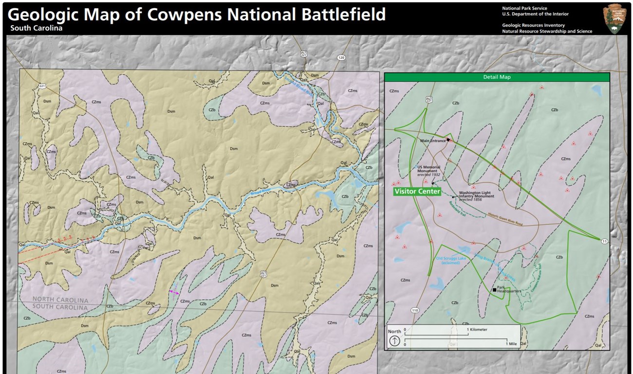
The bedrock of COWP reflects a long geologic history of deposition, metamorphism, mountain building, and erosion. Rocks that underlie COWP represent ocean sediments that were lithified, buried, metamorphosed, pushed up as part of the Six Mile thrust sheet, and folded and faulted during the formation of the Appalachian Mountains (Thornberry-Ehrlich 2020a). Only two geologic units are mapped in COWP and consist of late Proterozoic to early Cambrian-age quartz-rich mica schist and biotite gneiss. Weathered mica schist is mapped as part of an east–west trending ridge composed of a series of tight double-plunging folds that includes Thicketty Mountain. Biotite gneiss is predominantly mapped in southeastern COWP and underlies the lower valleys and occurs in stream bed exposures. These metamorphic units alternate in northeast–southwest trending bands oriented perpendicular to the compressive tectonic forces that occurred during the formation of the Appalachian Mountains (Thornberry-Ehrlich 2020a).
Geologic Features and Processes
Visible geologic features and active processes within the park include the following:
-
Fluvial Features, Processes, and Issues
-
Ravine Erosion
-
Old Scruggs Lake and Fossil Pollen Record
-
Restoration of 1781-era Wetlands, Green River Road, and Monuments
-
Bedrock Outcrops
-
Geologic Hazards (Earthquakes)
-
Faults and Folds
Regional Geology
Cowpens National Battlefield is a part of the Piedmont Physiographic Province and shares its geologic history and some characteristic geologic formations with a region that extends well beyond park boundaries.
- Scoping summaries are records of scoping meetings where NPS staff and local geologists determined the park’s geologic mapping plan and what content should be included in the report.
- Digital geologic maps include files for viewing in GIS software, a guide to using the data, and a document with ancillary map information. Newer products also include data viewable in Google Earth and online map services.
- Reports use the maps to discuss the park’s setting and significance, notable geologic features and processes, geologic resource management issues, and geologic history.
- Posters are a static view of the GIS data in PDF format. Newer posters include aerial imagery or shaded relief and other park information. They are also included with the reports.
- Projects list basic information about the program and all products available for a park.
Source: NPS DataStore Saved Search 2795. To search for additional information, visit the NPS DataStore.
A NPS Soil Resources Inventory project has been completed for Cowpens National Battlefield and can be found on the NPS Data Store.
Source: NPS DataStore Saved Search 2839. To search for additional information, visit the NPS DataStore.


