Last updated: June 14, 2024
Article
NPS Geodiversity Atlas—Chickasaw National Recreation Area, Oklahoma
Geodiversity refers to the full variety of natural geologic (rocks, minerals, sediments, fossils, landforms, and physical processes) and soil resources and processes that occur in the park. A product of the Geologic Resources Inventory, the NPS Geodiversity Atlas delivers information in support of education, Geoconservation, and integrated management of living (biotic) and non-living (abiotic) components of the ecosystem.

Introduction
Chickasaw National Recreation Area (NRA) preserves historic freshwater and mineral springs within a landscape of gently rolling hills and stream-cut ravines that are the erosional remnants of the Arkbuckle Mountains in the central lowlands of Oklahoma. The recreation area also includes Veterans Lake, and Lake of the Arbuckles formed by Arbuckle Dam, which was built by the US Bureau of Reclamation and completed in 1966.
The unique freshwater and mineral springs along Travertine and Rock creeks in Chickasaw NRA have been federally protected since 1902. The area was designated as Platt National Park in 1906. Between 1933 and 1940, the CCC built landscape features such as spring pavilions, creek dams, swimming holes, and stone picnic table and benches using area limestone, which today are important aspects of the Platt Historic District along with the springs. In1976. Platt National Park was combined with Arbuckle National Recreation Area and to form Chickasaw NRA and named to honor the Chickasaw Nation.
Geologic Features and Processes
Geologic features and processes identified in the park’s Geologic Resource Inventory include:
-
Freshwater and Mineral Springs
-
Vendome Artesian Well
-
Travertine Creek and Travertine Island
-
Paleontological Resources
-
Sedimentary Features in the Vanoss Formation
-
Folds and Faults
-
Cave and Karst Features
-
Rock Creek Drainage Basin
-
Bromide Hill
Geologic Setting
The recreation area is within the Arbuckle Uplift, one of five major basement-cored uplifts in Oklahoma. The geologic history of the Chickasaw region includes 4 major geologic events: (1) rifting, (2) deposition in shallow seas, (3) uplift and deformation, and (4) major erosion.
Prior to the deposition of rocks exposed in Chickasaw NRA, rifting took place during the Cambrian Period along the southern margin of the ancestral North American continent. From the Late Cambrian through Middle Mississippian periods, mostly marine sediments along with some terrestrial units were deposited in a variety of depositional environments. Mountain-building events during the Wichita and Arkbuckle orogonies faulted and folded these older rock layers during the formation of the Arbuckle Mountains.
The Late Pennsyvanian Vanoss Formation, which is exposed at the surface in most of Chickasaw NRA, was deposited in alluvial fans and plains during erosion of the Arbuckle Mountains. The unit sits atop a major unconformity. Millions of years of erosion followed and has reduced the former mountainous landscape to the rolling hills of the Chickasaw region.
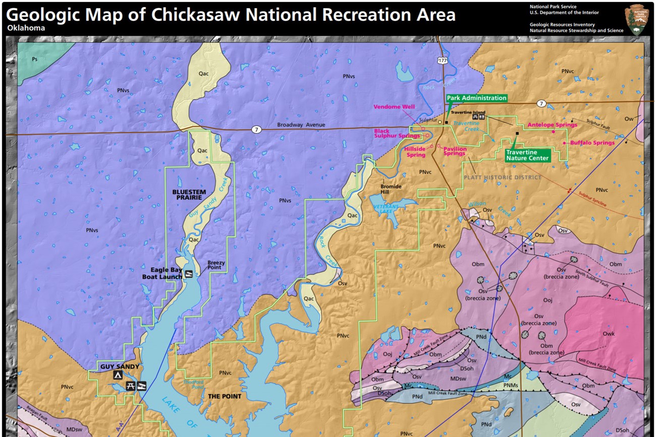
The Vanoss Formation consists of two units: a lower unit, which is a limestone conglomerate, and an upper shale-rich unit. The lower conglomerate averages 30 ft (9 m) thick and consists of limestone conglomerate with limestone boulders, cobbles and pebbles. The conglomerate unit caps Bromide Hill, which is the chief the chief topographic feature in the park, rising approximately 140 ft (43 m) above Rock Creek. The upper shale unit mostly contains shale and red sandstones, and is exposed mostly in the Guy Sandy area, and to the west of Rock Creek north of the upper end of the Lake of the Arbuckles.
Folds and Faults
Major structural features of the Chickasaw area include northwest-southeast oriented folds and faults, including the deep-seated Reagan Fault and Mill Creek Fault Zone (Blome et al. 2013). The Reagan Fault is the most significant major fault that runs through Chickasaw NRA. From northeast-to-southwest, folds include the broad Hunton anticline, Sulphur syncline, Belton anticline, Mill Creek syncline, Tishomingo anticline, and the Dougherty anticline.
These structural features are mapped primarily in the Paleozoic rocks to the east and along the southern border of Chickasaw NRA. Most of the faulting and folding took place during the Pennsylvanian Period during the Wichita and Arbuckle orogenies.

NPS photo.
Groundwater and Springs
The mineral and freshwater springs along Travertine and Rock creeks in Chickasaw NRA have had cultural, economic, and environmental significance throughout the history of the region, and their importance led to the establishment of the Sulphur Springs Reservation in 1902. In the early twentieth century, mineralized water was highly prized for its perceived medicinal value, and many thousands of visitors and local residents came annually to drink the spring water, especially that from Bromide Springs.
Dr. Charles Gould, professor of geology at the University of Oklahoma and head of the Oklahoma Geological Survey made the first comprehensive evaluation of Chickasaw’s springs in 1906. Gould documented 33 springs in eight groups based on their chemical character and proximity to one another.
In 1987, a National Park Service survey relocated 21 of these springs, although some springs only had seasonal flow. Over the years, many of the springs have been “improved” (altered) to enhance their scenic beauty and to provide visitors easier access to the water. With the exception of Antelope Spring, none of the remaining springs are in their natural condition.
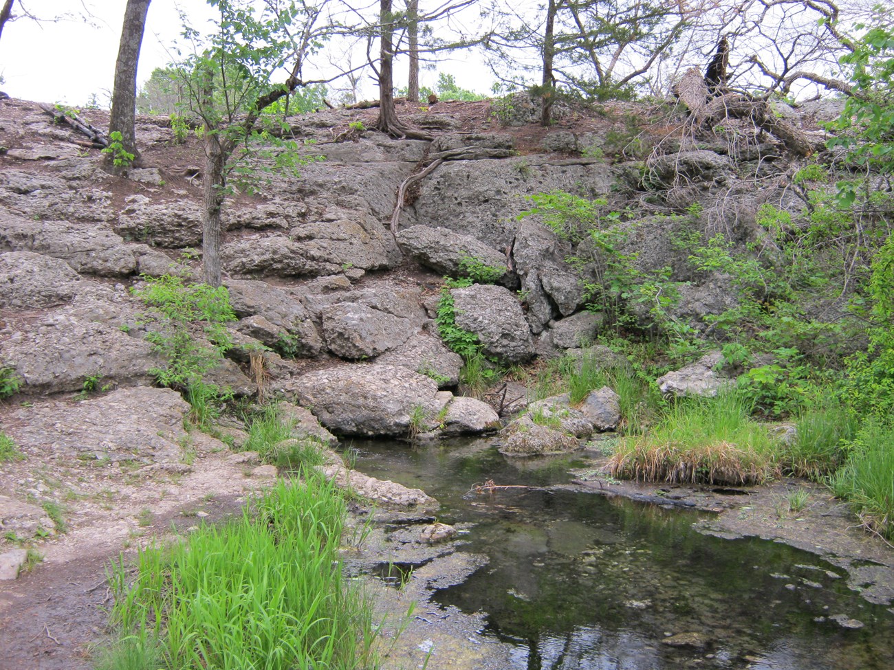
Today, the Platt District contains five named springs and spring groups: Antelope and Buffalo springs are considered to be freshwater springs, and Black Sulphur, Hillside, and Pavilion are mineralized. Bromide Springs, which was the most mineralized and arguably the most popular of the springs, has been dry since 1974. Venedome Well is an artesian well with an artificial creek with wading pools, meandering course, waterfalls, and foot bridges that is a popular tourist attraction in Chickasaw NRA where visitors routinely collect jugs of sulphur water from a spigot at the well.
Travertine Creek begins immediately to the east of the Platt Historic District and flows about two miles through the district before joining Rock Creek. Travertine Creek flows intermittently until it reaches Antelope and Buffalo springs, the primary freshwater springs in Chickasaw NRA that also provide the majority of Travertine Creek’s baseflow.
Water from Antelope and Buffalo springs contains abundant dissolved calcium carbonate, which precipitates out as travertine terraces and has formed the deposits on Travertine Island. Travertine deposits are important because they indicate areas of current and past springs and seeps, which are the surface discharges of an aquifer. They can provide information about the geohydrology of an area through time. For example, travertine deposits located away from the current drainage system may indicate the location of springs that are no longer active.
Travertine Creek flows into Rock Creek near Lincoln Bridge, a stone bridge built in 1909 to connect the town of Sulphur to the mineral springs south of the creek. Rock Creek is the largest stream entering Chickasaw NRA and receives mineral-rich water from Black Sulphur, Pavilion, and Hillside springs. It flows into the Lake of the Arbuckles.
The historic springs in Chickasaw are supplied by water from the Arbuckle-Simpson aquifer. This aquifer is contained in three major rock units: the Timbered Hills, Arbuckle, and Simpson Groups. Rocks that contain the Arbuckle-Simpson aquifer outcrops over greater than520 mi2 (1,300 km2) in south-central Oklahoma, and the aquifer also extends into the subsurface in some areas, such as under Chickasaw NRA. The overlying Vanoss Formation acts as a confining layer for the Arbuckle-Simpson aquifer.
The primary source of groundwater in the Arbuckle-Simpson aquifer is diffuse recharge from precipitation in the outcrop area. Groundwater in the outcrop area, where the aquifer is recharged with rainwater, is considered fresh with low dissolved solids. Outside of the outcrop area of the aquifer, the water chemistry changes quickly and becomes saline.
Dissolved solids concentrations in water samples from springs in the Platt Historic District increase from east to west more than tenfold within a distance of less than 3 miles. This increase in dissolved solids concentrations is likely a result of mixing of fresh groundwater originating from recharge and a small amount of brine from the saline part of the aquifer. The mineralized springs contain high concentrations of sodium and chloride, which gives the water a salty taste, and hydrogen sulfide, which imparts a sulfuric, rotten-egg odor.
Paleontological Resources
Chickasaw NRA preserves an excellent geologic record of the Paleozoic Era, with rocks ranging in age from approximately 470 million years old (Middle Ordovician) to approximately 300 million years old (Late Pennsylvanian) exposed within park boundaries. A wide range of marine invertebrate fossils, along with some vertebrate, plant, and trace fossils, have been documented from ten of stratigraphic units exposed in the recreation area.
Marine invertebrate fossils including brachiopods, echinoderms, trilobites, pelecypods, bryozoans, graptolites, and ostracods are the most common types of fossils found in Chickasaw NRA. These fossils provide important information about the depositional environments, water depths, and shoreline geometries during the time during the Paleozoic when present-day Oklahoma was covered by an extensive inland sea. Vertebrate fossils include conodonts, and a species of acanthodian fish that was collected in the 1970s. Plant fossils include microfossils, pollen and spores. Burrows have been identified from at least two different stratigraphic units. Fossils have not been found in all parts of the recreation area. No fossils have been observed in the Vanoss Formation.
In 2016, the first official National Park Service PaleoBlitz was held in Chickasaw NRA. Like a BioBlitz, a PaleoBlitz is an intense period of surveying to record targeted natural resources in a designated area. Chickasaw was chosen for this initial PaleoBlitz because it has significant paleontological resources, but little previous work had been done there, and because the opportunity to partner with Goddard Youth Camp for public education. After a day of discovery where known fossil localities were visited by paleontologists from the National Park Service, the Sam Noble Museum of Natural History, and Goddard Youth Camp, a full-day fossil festival was held for the public.
All NPS fossil resources are protected under the Paleontological Resources Preservation Act of 2009 (Public Law 111-11, Title VI, Subtitle D; 16 U.S.C. §§ 470aaa - 470aaa-11).
Related Links
Armstrong ML and Others. 2016. Paleontological resource inventory at Chickasaw National Recreation Area, Oklahoma. Pages 5-11. In Sullivan RM and Lucas SG (ed). Fossil Record 5. New Mexico Museum of Natural History and Science. Albuquerque, NM. New Mexico Museum of Natural History and Science Bulletin. Bulletin 74
https://irma.nps.gov/DataStore/DownloadFile/556194
Korn, A.S., M. L. Armstrong, V. L. Santucci, and J. Tweet. 2016. Chickasaw National Recreation Area paleontological resources inventory (Public Version). Natural Resource Report NPS/CHIC/NRR—2016/1276. National Park Service, Fort Collins, Colorado.
https://irma.nps.gov/DataStore/DownloadFile/554406
2016 Fossil Festival and Paleoblitz
https://www.nps.gov/chic/learn/nature/paleoblitz.htm
Cave and Karst
Chickasaw NRA does not contain any documented caves or sinkholes, and no significant caves. However, small dissolution caves have formed in the travertine deposits on Travertine and small caves are associated with fractures in the conglomerate unit of Vanoss Formation at Bromide Hill.
Approximately 9% of the area of Chickasaw NRA has been identified as being known or potential karst based on the extent of exposure of soluable rocks exposed at the surface or buried at shallow depth.
The Arbuckle-Simpson aquifer is a massive karst feature more 50 mi (80 km) across extends well beyond the recreation area. Weathering of the carbonates in the Arbuckle Group produce features indicative of karst development, such as dissolution cavities, collapse breccias, dissolution-enlarged fractures, and vuggy porosity. Fracturing and brecciation also increases the permeability of the aquifer.
All NPS cave resources are protected under the the Federal Cave Resources Protection Act of 1988 (FCRPA)(16 U.S.C. § 4301 et seq.).
Related Links
Evaluation of Cave And Karst Programs And Issues At US National Parkshttp://www.nckri.org/about_nckri/investigations/NCKRI_RI4.pdf
Geohazards
Natural geologic processes continue to shape the recreation area on time scales ranging from seconds to years, and visitors should be cautious and alert to geohazards that may be present.
Slope movements, particularly rockfall, may affect parts of Chickasaw NRA, especially at Bromide Hill. Flash flooding and debris flows also present a potential hazard along Rock Creek and Guy Sandy Creek. Flooding and intense rainfall events may also raise the water level in Lake of the Arbuckles also creating flooding. Further, there is an increased potential for severe storms and potentially higher risk of flooding with climate change.
Historically, Oklahoma has had few earthquakes and a relatively low seismic hazard. Southern Oklahoma does have a slightly higher seismic hazard than most areas of the central and eastern United States because of the Southern Oklahoma Aulacogen (a sediment-filled failed rift), which formed when North America experienced incipient rifting during the break up of the supercontinent Rodinia in the late Proterozoic. The Meers Fault is located in this failed rift zone and has been active in the late Quaternary.
In the last decade or so, Oklahoma has experienced a dramatic increase in earthquakes. These earthquakes are thought to have been induced by injection of wastewater from oil and gas production in deep wells. While no earthquake with an epicenter within the boundaries of Chickasaw NRA has occurred, earthquakes have occurred in the region, and oil and gas development, including injection wells, is located west of the recreation area.
Related Links
USGS Earthquakes Hazard Program—Information by Region-Oklahoma
Abandoned Mineral Lands
Two sites in Chickasaw NRA were mined for gilsonite, an asphalt-like rock. These sites are included in the National Park Service’s inventory and assessment of Abandoned Mineral Lands.
NPS AML sites can be important cultural resources and habitat, but many pose risks to park visitors and wildlife, and degrade water quality, park landscapes, and physical and biological resources. Be safe near AML sites—Stay Out and Stay Alive!
Regional Geology
Chickasaw National Recreation Area is a part of the Central Lowland Physiographic Province and shares its geologic history and some characteristic geologic formations with a region that extends well beyond park boundaries.
- Scoping summaries are records of scoping meetings where NPS staff and local geologists determined the park’s geologic mapping plan and what content should be included in the report.
- Digital geologic maps include files for viewing in GIS software, a guide to using the data, and a document with ancillary map information. Newer products also include data viewable in Google Earth and online map services.
- Reports use the maps to discuss the park’s setting and significance, notable geologic features and processes, geologic resource management issues, and geologic history.
- Posters are a static view of the GIS data in PDF format. Newer posters include aerial imagery or shaded relief and other park information. They are also included with the reports.
- Projects list basic information about the program and all products available for a park.
Source: NPS DataStore Saved Search 2788. To search for additional information, visit the NPS DataStore.
A NPS Soil Resources Inventory project has been completed for Chickasaw National Recreation Area and can be found on the NPS Data Store.
Source: NPS DataStore Saved Search 2846. To search for additional information, visit the NPS DataStore.
Related Articles
Chickasaw National Recreation Area
National Park Service Geodiversity Atlas
The servicewide Geodiversity Atlas provides information on geoheritage and geodiversity resources and values within the National Park System. This information supports science-based geoconservation and interpretation in the NPS, as well as STEM education in schools, museums, and field camps. The NPS Geologic Resources Division and many parks work with National and International geoconservation communities to ensure that NPS abiotic resources are managed using the highest standards and best practices available.


