NPS photo.
Introduction
The landscapes of our national parks, as well as geologic hazards such as earthquakes and volcanic eruptions, are due to the movement of the large plates of Earth’s outer shell.
There are three types of tectonic plate boundaries:
- Plates rip apart at a divergent plate boundary, causing volcanic activity and shallow earthquakes;
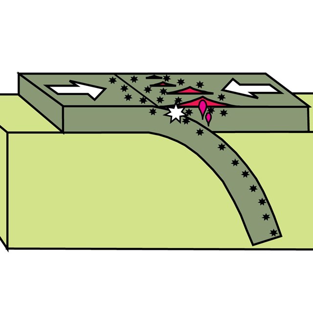
- At a convergent plate boundary, one plate dives (“subducts”) beneath the other, resulting in a variety of earthquakes and a line of volcanoes on the overriding plate;
- Transform plate boundaries are where plates slide laterally past one another, producing shallow earthquakes but little or no volcanic activity.
Another large-scale feature is a hotspot, where a plate rides over a rising plume of hot mantle, creating a line of volcanoes on top of the plate. National Park Service lands contain not only active examples of all types of plate boundaries and hotspots, but also rock layers and landscapes that reveal plate-tectonic activity that occurred in the distant past.
Plate Boundaries and Hotspot Demonstration
Oreo® cookies are a fun way to demonstrate the three types of plate boundaries and a hotspot. (Modified from “Oregon's Island in the Sky: Geology Road Guide to Marys Peak, by Robert J. Lillie, Wells Creek Publishers, 75 pp., 2017, www.amazon.com/dp/1540611965).
Divergent Plate Boundary
Volcanic eruptions and shallow earthquakes are common where plates rip apart.

Convergent Plate Boundary
Where plates crash together, one dives (“subducts”) beneath the other, causing volcanoes (red triangles) to erupt on the overriding plate and earthquakes (black stars) at a variety of depths. The large white star represents the zone where plates lock together for centuries then suddenly let go, causing the largest earthquakes.

Transform Plate Boundary
Shallow earthquakes and little volcanism occur where one plate slides laterally past another.

Hotspot
In places like Hawaii and Yellowstone, a plate rides over a rising plume of hot mantle, causing earthquakes and a chain of volcanoes.

Photos and illustrations above modified from “Oregon's Island in the Sky: Geology Road Guide to Marys Peak, by Robert J. Lillie, Wells Creek Publishers, 75 pp., 2017, www.amazon.com/dp/1540611965.
How fast do the plates move?
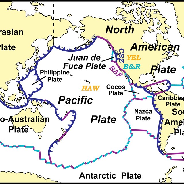
Look at your fingernails and watch them grow. That will give you an idea of how fast the plates move relative to one another—about a fraction of an inch to a few inches per year! That doesn’t seem like much, but over time it adds up. For example, moving at about 2 inches (5 centimeters) per year, in our lifetime the Pacific Plate moves 10 to 15 feet (3 - 5 meters) past the North American Plate along the San Andreas Fault, a transform plate boundary in California. As Europe and Africa move away from North and South America at about 1½ inches (4 centimeters) per year, the Atlantic Ocean has opened to a width of 4,000 miles (6,000 kilometers) in the past 150 million years!
Geoscience Concepts—Plate Tectonics
Figures Used
Related Links
Site Index & Credits
Plate Tectonics and Our National Parks
- Plate Tectonics—The Unifying Theory of Geology
- Inner Earth Model
- Evidence of Plate Motions
- Types of Plate Boundaries
- Tectonic Settings of NPS Sites—Master List
Teaching Resources—Plate Tectonics
Photos and Multimedia—Plate Tectonics
Geological Monitoring—Plate Tectonics
Plate Tectonics and Our National Parks (2020)
-
Text and Illustrations by Robert J. Lillie, Emeritus Professor of Geosciences, Oregon State University [E-mail]
-
Produced under a Cooperative Agreement for earth science education between the National Park Service's Geologic Resources Division and the American Geosciences Institute.
Last updated: February 11, 2020


