Last updated: December 13, 2020
Thing to Do
Summer Bay Road
Turn right out of the Visitor Center parking lot onto Airport Beach Road. Continue on this road until you cross the Iliuliuk River Bridge into the Unalaska Town Site. On the north side of the bridge, Airport Beach Road becomes 5th Street. At the first intersection, turn right onto Broadway Avenue then left at King Street. At the end of King Street, turn right onto Bayview Avenue and continue past Unalaska Memorial Park and Cemetery. After this point, Bayview Avenue becomes Summer Bay Road.
Fort Brumback on Morris Cove was one of the eastern points of Dutch Harbor’s coastal defense network known as “The Iron Ring.” Construction of the fort and access road, Summer Bay Road, began in 1942. Army Garrison No. 6 included administration buildings, mess halls, 10 barracks buildings, and 70 Quonset huts. A few badly deteriorated Quonsets are all that remain of these buildings. However, a number of Fort Brumback’s defensive fortifications, located between Summer Bay and Humpy Cove, are still standing.
Fort Brumback on Morris Cove was one of the eastern points of Dutch Harbor’s coastal defense network known as “The Iron Ring.” Construction of the fort and access road, Summer Bay Road, began in 1942. Army Garrison No. 6 included administration buildings, mess halls, 10 barracks buildings, and 70 Quonset huts. A few badly deteriorated Quonsets are all that remain of these buildings. However, a number of Fort Brumback’s defensive fortifications, located between Summer Bay and Humpy Cove, are still standing.
Details
Activity
Scenic Driving
Pets Allowed
Yes
Activity Fee
No
Entrance fees may apply, see Fees & Passes information.
Reservations
No
Time of Day
Day
Accessibility Information
This activity is accessible for all visitors with vehicle access. This is intended as a driving guide. Participants can chose their own level of participation and activity.

Named for its resemblance to Priest Rock, some 4 miles north, Second Priest Rock was a familiar landmark for the men of Garrison No. 6, as well as those stationed at Fort Schwatka on Mount Ballyhoo.
Mile 6.5 - Tramway Remains
A track of rusted steel rails on the side of Mount Coxcomb is all that remains of a wood and steel tramway that once transported supplies up the mountain to a searchlight station overlooking Iliuliuk Bay. Opinions differed on the usefulness of the 800-million-candlepower searchlight. One former member of Battery A recalled that when the light was shined vertically, it became a homing device for navy pilots trying to land in heavy fog. Another believed that the searchlight was of little use in the thick Aleutian fog, and it “more likely would have guided the enemy to us” (Jodie Jones and John Proffitt, interviews in The Williwaw War).

The most common function of this structure, also known as an Armco hut, was munitions storage, but elephant steel shelters were also used as generator buildings, plotting rooms, and searchlight shelters. The magazine was constructed on a concrete foundation with 10-foot panels of corrugated steel bolted together to form the roof and sides. No internal bracing was required. The entrance is a 10-foot-wide piece of corrugated steel pipe. The iron bulkhead above the entrance and at the back provided additional support to the exterior of the magazine when it was camouflaged with earth.
Mile 7.3 to 7.4 - Panama Mounts
Each of the circular tracked Panama mounts supported a 155-mm gun that was removed from the mount when not in use. The track enabled the gun to rotate a full 360 degrees. It took three men to operate these guns: the gun point, who pointed the gun in the right direction; the elevation setter, who raised the gun to the angle for the range; and the gunner, who fired the gun.

These four structures, sometimes called fusee huts or igloo huts, contained ammunition fuses, which were stored separately from the ammunition.
Mile 7.8 - Munitions Magazine
This elephant steel magazine was originally camouflaged with earth, grass, and brush. The only parts of the structure that were visible were the entryway and the vent pipe.

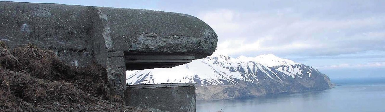
This two-tiered concrete structure on the hillside provided a sweeping view of Iliuliuk Bay. Its position, shape, and lack of color also provided a degree of camouflage. The soldiers at this post used a scope to measure the azimuth (angular distance) between a target (approaching enemy vessels or aircraft) and the Base End Station. This measurement was then relayed to personnel in the plotting room, who used the information to calculate the correct range and firing angle for the 155-mm guns.
Mile 8.3 - Bridge
Driving Route 6 ends at the parking area just before the bridge. The road up the hill leads to Morris Cove. It is extremely rough and recommended only for 4-wheel drive vehicles.
