Last updated: December 13, 2020
Thing to Do
Upper Unalaska Valley
Turn right out of the Visitor Center parking lot onto Airport Beach Road. Continue on this road until you cross the Iliuliuk River Bridge into the Unalaska Town Site, where Airport Beach Road becomes 5th Street. At the corner of 5th Street and Broadway Avenue, turn right onto Broadway Avenue and follow the road until you reach the washout.
The Move to Unalaska Valley
After the 1942 bombing of Dutch Harbor, work began almost immediately on moving Fort Mears operations from Margaret Bay to Unalaska Valley, a more geographically protected area. By 1943, construction of the new installation (designated Garrisons 2 and 5) was completed, and the men of Garrison 1 were now quartered in 46 barracks buildings and 14 officers quarters, in addition to 674 Quonset huts and 350 cabanas scattered randomly throughout the valley. After the battle on Kiska Island in 1944, the army established the North Pacific Combat School in an area of Lower Unalaska Valley known as Ski Bowl (J. Dickrell).
Details
Activity
Scenic Driving
Pets Allowed
Yes
Activity Fee
No
Entrance fees may apply, see Fees & Passes information.
Reservations
No
Time of Day
Day
Accessibility Information
This activity is accessible for all visitors with vehicle access. This is intended as a driving guide. Participants can chose their own level of participation and activity.

Mile 5.3 - Water System Remnants
On the creek bank at the washout are traces of the original World War II water system. The rectangular concrete structure on the left was the chlorination station. Protruding from the bank to the right of the station are wood-stave water pipes wrapped with wire.
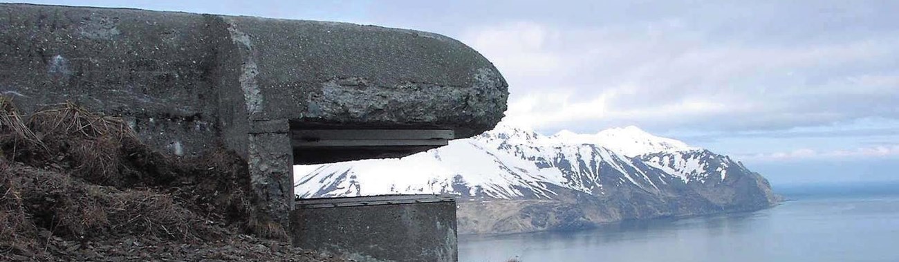
Mile 5.3 - Munitions Magazines (1942-1943)
When you reach the washout at the end of the road, look to your left across the river. The two black tunnel-like openings in the hillside are the entrances to munitions magazines known as elephant steel shelters or Armco huts. These structures were built of panels of heavy-gauge corrugated steel bolted together and covered with soil. Grass and willow soon grew over the soil, making the shelters very difficult to detect.

Soon after the Fort Mears troops moved to Unalaska Valley in July 1942, testing revealed that the water supply for the new garrisons was contaminated. The source of the contamination was traced to living quarters located above the watershed. Although personnel quarters were immediately moved down the hillside below the watershed, by the end of the year it became necessary to strictly ration water use. During this time, an “outbreak of acute gastro-enteritis was traced to unclean messing gear due to a shortage of available hot water … in the galleys” (War Diary: Dutch Harbor, Alaska).
As soon as the snow melted in Pyramid Valley the following spring, work began on a new water system. Water from Pyramid Creek was channeled through 16- inch-diameter wood-stave and cast-iron pipe at Icy Creek Dam. From here, waterlines ran to Amaknak Island and to two dams in Upper Unalaska Valley. Water flowed from these dams downhill to the chlorination facility (Mile 5.3) before reaching Garrisons 2 and 5.
When completed, the new water system provided a fresh water supply of approximately 3,500,000 gallons per day to all the military installations on Amaknak and Unalaska islands. This water system served the City of Unalaska for many years after the war. Remnants of wood-stave pipe can still be seen in Unalaska and Pyramid valleys and on the shore of Unalaska Bay.
