Diving in Apostle Island National Park
The Apostle Islands are an archipelago of 22 islands that form an extension of the Bayfield Peninsula, stretching into Lake Superior from northernmost Wisconsin. The islands are all the land that remained after glacial ice scoured out the basin of Lake Superior. The dynamics of ice wind and water have sculpted scenic shorelines composed of glacial drift and sandstone bedrock into shapes reminiscent of those in the American Southwest. The park property covers approximately 70,000 acres of which about 40 percent is underwater.
Towards the end of the 19th century, six lighthouses were constructed in this area to protect maritime traffic from treacherous shoals. To the grief of mariners but of interest to modem-day divers, these lighthouses were not always successful in preventing accidents in such rough waters on seas subject to heavy winter storms. Over a hundred shipwrecks have occurred in the area, creating over two dozen known wreck sites, some of which make for excellent diving.
The Apostles are a popular destination for vacationers from Chicago and the Twin Cities, but they have been spared the crowds of visitors who are drawn to the more southern water areas in the park system. They are much more accessible than Isle Royale and offer many of the same attractions.
BASICS
Location: Northern Wisconsin, Lake Superior
Elevation: 600 feet
Skill level: Intermediate to advanced
Access: Boat
Dive support: Bayfield, WI
Best time of year: Summer
Visibility: Moderate to excellent (30-70 feet)
Highlights: Shipwrecks, caves, depth
Concerns: Waters are dangerously cold and sudden storms arise
Dive Site Map
Dive Overview
Divers should register at the headquarters in Bayfield and obtain a National Park Service diving permit. It's needed to scuba dive park waters, which include all waters within a quarter mile of shore and, incidentally, almost all shipwrecks and major diving attractions.
Dives include natural features like sea cliffs and caves, historic docks, and an excellent assortment of shipwrecks. The Eastern National Parks and Monuments Association has produced an excellent brochure on park diving, available free from headquarters in Bayfield. Their literature lists sixteen sites including eight shipwrecks. The brochure gives location and conditions for all the sites; of those, we think the five that will follow deserve special attention. More information on diving in the park is available at http://www.nps.gov/apis/planyourvisit/diving.htm
Dive Sites
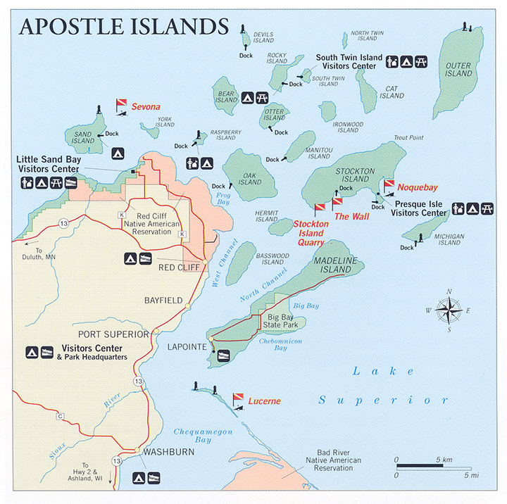
NOQUEBAY
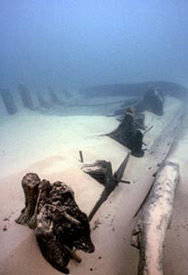
The Noquebay is particularly close to the heart of the SRC staff, who led the National Park Service team that first dived this site. On a routine overflight, park staff spotted the site from the air. SRC divers (then SCRU) confirmed it in July 1984. By September of that year, SCRU, park staff, and volunteer divers had fully mapped the site. The Noquebay was a 205-foot schooner barge, which was built in 1872 and which burned and sank in 1905. The vessel lies splayed open in less than 15 feet of water. When the first survey line over the site, it was tied off one end to the handgrip of a ship's wheel extruding from the sand. Later test excavation determined the wheel was still attached to the steering assembly.
The only object NPS divers removed from the site for preservation and museum display was the ship's bell. We hope that with the park's protection and the cooperation of the sport diving community, the Noquebay will retain the same magic we encountered on our first dive.
STOCKTON ISLAND QUARRY
First dived by NPS divers in 1981, this is an interesting example of a land-based complex that has left archaeological residues underwater: dock supports, the remains of wagons, and other items used in quarrying sandstone.
SEVONA
At this site are the remains of a 373-foot bulk freighter that was built in 1890 and sunk in 1905. It is located on the Sand Island Shoals outside of the park boundary at Loran coordinates provided in the park diving brochure. Because it is at a depth of only 25 feet, the vessel is popular with divers. The ship is broken in half with iron ore still present in its stern section.
LUCERNE
This is the site of a 195-foot schooner that sank in 1886. In addition to an intact hull, this site includes iron ore still visible around the wreck. It lies on the northeast side of Long Island outside the park boundary. Be aware that a two-knot current is common in this area. In case your memory needs jogging, two knots is a strong current.
THE WALL
For those interested in depth, we offer "the Wall." On the southwest side of Stockton Island, this steep layer cake of sandstone ledges drops off quickly to over 100 feet. Coordinates for the spot are available from the park when you pick up your permit.
DIVING RULES AND REGULATIONS
A National Park Service diving permit is required within park boundaries, which include all waters within one quarter mile of shore.
A diver-down flag must be displayed while divers are in the water. Both the red and white diver-down flag and the international blue and white alpha flag are acceptable.
Possession or use of underwater metal detectors in park waters is expressly prohibited.
When anchoring on shipwrecks, avoid setting anchors into the wreck itself.
Last Updated: October 26, 2012


