NPS Photo
Roosevelt Dam
Gila and Maricopa Counties, AZ
Designated an NHL: May 23, 1963
Designation withdrawn: March 10, 1999
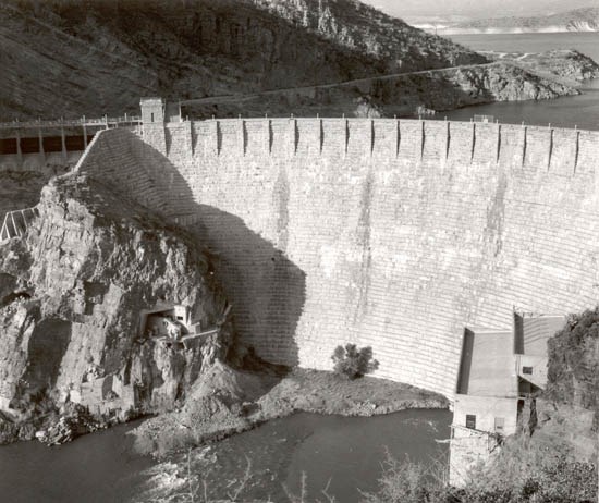
One of the original five federal projects authorized on March 13, 1903, under the Reclamation or Newlands Act of 1902, Roosevelt Dam was the first major project to be completed under the new federal reclamation program. This, the world's highest masonry dam, was started in 1906 and completed in 1911. The beginning of federal production of electric power occurred at Roosevelt Dam when Congress, in 1906, authorized the Reclamation Service to develop and sell hydroelectric power at the Salt River Project.
The Reclamation Act of 1902 created the United States Reclamation Service whose purpose was to design and construct irrigation projects to aid the settlement of the arid west. Previous efforts by individuals and private irrigation companies were inadequate and often unsuccessful. With the creation of the Reclamation Service, the lead role of the federal government in developing large-scale irrigation projects was firmly established.
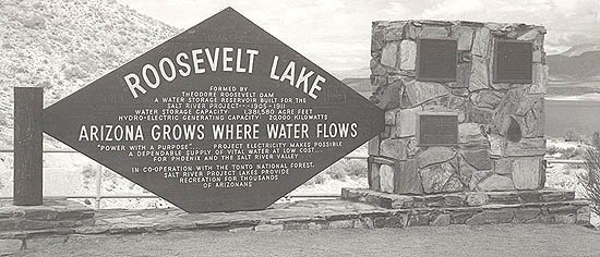
Roosevelt Dam, as originally conceived and built, was to be a symbol of success and a showpiece for the new agency. Service. Completed at a cost of 10 million dollars, the primary function of the dam was to provide water storage for the Salt River irrigation project and flood control for the Salt River Valley. The dam contributed more than any other dam in Arizona to the settlement of Central Arizona and to the development of large-scale irrigation there. A secondary purpose of the dam was to generate a moderate amount of hydroelectric power. The lake created behind the dam, known as Lake Roosevelt, contained more than a million acre-feet of water and was the world's largest artificial lake.

NPS Photo
As early as 1889, the narrow canyon below the confluence of the Salt River and Tonto Creek had been identified as a promising dam site by Maricopa County representatives who wanted to convince federal legislators of the need for water storage in the Salt River Valley. Despite the efforts of the county, little federal interest in the Tonto Basin site was shown until 1901 when the Geological Survey conducted studies there in response to lobbying efforts by influential irrigation advocates, Benjamin Fowler and George Maxwell. Leading the investigations was Arthur Powell Davis, a nephew of John Wesley Powell who would later become head of the Reclamation Service. Davis' report was published in 1903 under the title "Water Storage on the Salt River, Arizona." In this document, Davis provided fairly complete plans for a dam and power facility at what later became known as the Roosevelt site.
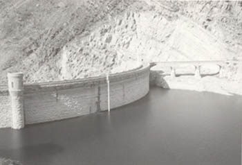
The formal submittal of Davis' report to Charles Wolcott, Director of the Geological Survey in June 1902, coincided with the passage of the Reclamation Act of 1902. Among the first five projects advocated for construction by the Geological Survey and approved by Interior Secretary Ethen A. Hitchcock was the Salt River Project. Final plans for construction of the dam, published in the Third Annual Report of the Reclamation Service (1905) adhered closely to those outlined in Davis' earlier report. These plans called for a masonry gravity arch structure with two large spillways - one at each end of the dam - to carry away excess floodwaters and prevent overtopping of the structures. This type of dam, gravity arch, retains water behind it by means of its weight and the compressive force of the arch.
By 1903, Reclamation Service engineers were conducting initial work in preparation for the dam construction. Building the monumental structure across the Salt River in this inaccessible spot posed enormous challenges. The dam site was linked to the capital city of Phoenix some 60 miles away by only a few primitive trails through the Salt River Canyon. The site was closer to Globe, a mining town of a few thousand residents located 35 miles southeast of the dam site. Reclamation opted for a road between Mesa and the dam, crossing some extremely rugged terrain.
In addition to the road, numerous support facilities were needed to bring the dam project to successful completion. A diversion dam and power canal brought water to the dam site to generate hydroelectric power during construction. Some quarries provided limestone, sandstone, and clay needed to produce cement and concrete, while others provided the great stone blocks for the masonry dam itself. Plants built near the dam produced sand and cement; logging and milling camps in the Sierra Ancha Mountains to the east of the Tonto Basin supplied lumber. Work on these ancillary facilities began in 1903.
It was three years from the start of the project before the first stone block of the dam was placed. This occurred on September 20, 1906. The contract for the dam's construction had been awarded on April 8, 1905 to the low bidder, John M. O'Rourke and Company of Galveston, Texas. The price was $1,147,600 and they anticipated completing the dam within two years. As it turned out, this time frame proved impossible to meet due to continual delays that plagued the project.
Initial steps in the dam construction involved clearing the foundation so that the masonry could be placed directly on solid bedrock. In order to accomplish this, water had to be diverted around the site. Temporary upstream and downstream cofferdams and a timber flume intended to channel water through the damsite were designed for this purpose. Heavy flooding destroyed or damaged these features on several occasions, severely disrupting progress. After serious flooding in November 1905 destroyed the upstream cofferdam and timber flume, O'Rourke and the Reclamation Service agreed that reconstructing the flume would be useless; they decided instead to use the sluicing tunnel already drilled through the south canyon wall as the exclusive means of diverting water around the damsite.
On June 13, 1906, water began to flow through the sluicing tunnel and the job of clearing the foundation could begin in earnest. Once all dirt and loose rock had been removed from the foundation, the next step was the placement of masonry. The contractor had opened a quarry above the damsite on the north side of the canyon to quarry the sandstone blocks and smaller spalls. Large stones blasted from the quarry were further reduced in size using a non-explosive method known as "plug and feather." This method was used to avoid any explosive shocks that could damage the rock.

NPS Photo
Once quarried, stone was transported to the dam by two 1200-foot long Lidgerwood cableways that extended from one side of the canyon to the other, 350 feet above low water. These cableways supported buckets that could be moved horizontally and lifted vertically. With a capacity of ten tons, they had the ability to haul extremely massive stones. The buckets also transported large quantities of mortar and concrete from the mixing plant to the dam. The mortar and concrete were delivered to the dam at completely different times than the large stones. The latter were always carried at night to the general location where they would be laid up the next day. During daytime, the cableways were used to carry mortar and concrete directly to the particular site where masonry was in the process of being placed.
The actual process of building the dam was actually quite straightforward. Stone delivered by the cableways was placed near its final position by one of five wooden derricks. Then the cableways delivered a batch of mortar and dumped it where the stone was to be embedded. Shortly after, the stone was lowered slowly onto the mortar and tamped down lightly to eliminate any voids or air pockets. In the vertical spaces between the stones, O'Rourke's crew placed concrete and filled the large spaces with spalls. The masonry was kept wet for several days to make sure that it set properly without prematurely drying. After this, the stones and concrete were ready to form the base for another stepped layer of masonry.
By June 1909, the dam had reached a height of 170 feet at the south end and 100 feet at the north. It was almost 75% complete, by volume. That same month, the first two of six planned generating units in the permanent power plant were put into operation. A third unit was placed in service in August 1909 after which the temporary power unit was dismantled. The transformer house was completed at the same time. Both the power plant and the transformer house were built by government employees.
The following June, the Reclamation Service declared the dam to be "practically complete" except for a small amount of work remaining to be done on the parapet walls, the spillways, and the reinforced concrete bridges over the spillways. When the final stone was laid in Roosevelt Dam on February 5, 1911, the dam contained a total of 344,000 cubic yards of masonry. A month later, amid great fanfare, the dam was dedicated.

NPS Photo / J. Madrigal, Jr., Bureau of Reclamation
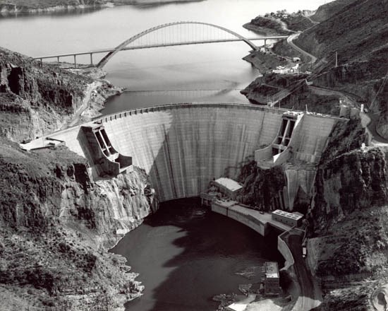
Roosevelt Dam was designated a National Historic Landmark on May 23, 1963. In 1984, the Secretary of the Interior approved the modification of Roosevelt Dam as a part of the Central Arizona Project's Plan 6. Modifications were designed to meet Safety of Dams standards and for flood control purposes. Engineers had determined that the dam could not safely release water during a maximum flood event. In addition, an event called a maximum credible earthquake occurring near the dam could potentially cause it to fail. Subsequent to the modifications begun in 1989 and completed in 1996, Roosevelt Dam has a completely altered appearance. The original rubble-masonry gravity arch dam is now encased in a new concrete block structure. The original dam had a structural height of 280 feet and measured 723 feet long at the crest; the dam now has a structural height of 357 feet and a crest length of 1,210 feet. After modifications, the dam no longer retained integrity of design, materials, workmanship, feeling, or association.
Accordingly, the Landmark designation of Roosevelt Dam was withdrawn on March 10, 1999. The Theodore Roosevelt Dam National Register District remains listed on the National Register of Historic Places. This district contains resources associated with the initial construction of Roosevelt Dam, but the dam itself is a noncontributing structure.
Last updated: August 29, 2018
