Learn About the Park


For 1,250 miles, the Rio Grande forms the boundary between the United States and Mexico. In a remote stretch in West Texas, the river makes a curve to the northeast to form the “big bend.” Winding its way through deep canyons and vast desert expanses, it is here that the wild character of the river lives on.
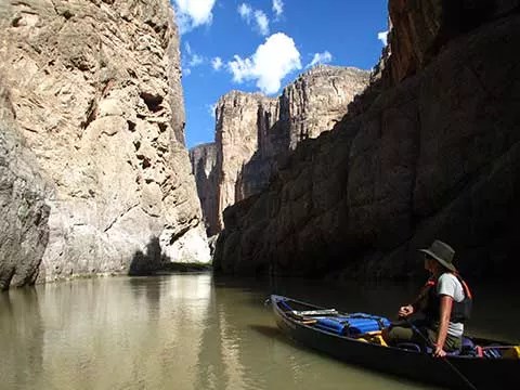
 
Park Ranger floating through Mariscal Canyon
Admiring the beauty of Mariscal Canyon

NPS

Why Is It Special?

In 1968, Congress passed the National Wildand Scenic Rivers Act to protect free flowing rivers with “outstandingly remarkable scenic,recreational, geologic, fish and wildlife, historic, cultural, or other similar values.”

As part of the only river system in the Chihuahuan Desert, the Rio Grande serves as the lifeblood for numerous threatened species. Recognizing the dramatic scenery and spectacular geology, as well as the recreational opportunities, and vital habitat it provides for plants and animals, Congress established the Rio Grande Wild and Scenic River as a unit of the National Park System on November 10, 1978.

Today, Congress has designated more than 225 rivers as National Wild and Scenic Rivers. Of the country’s 3.5 million miles of rivers, only 13,412 miles are designated. In fact, only 2% of the rivers in the United States are free flowing and pristine enough to qualify for wild and scenic designation.


Boundaries

The Wild and Scenic designation applies to 200 miles of the United States portion of theRio Grande from the Chihuahua-Coahuila (Mexico) state line upstream of Mariscal
Canyon to the Terrell-Val Verde county (Texas) line. The national park sections of Rio Grande upstream of Mariscal Canyon, including Santa Elena Canyon are not part of
the Wild and Scenic River.

In 2009 the government of Mexico established the Monumento Natural Rio Bravo del Norte, thereby protecting the Mexican half of the river for 300 miles.Together, Big Bend National Park and the Rio Grande Wild and Scenic River protect 250 miles of river – one fifth of the section of the Rio Grande that is shared by the United States and Mexico.

Most of the U.S. land downstream from Big Bend National Park is privately owned. Rights of private landowners must be respected on both sides of the river.

 
Map of the Rio Grande Wild and Scenic River
Map of Rio Grande Wild and Scenic River
 

Challenges for the Future

The Rio Grande is a slender ribbon of life that supports a myriad of plants and wildlife. People find a haven here, too. Recreation and solitude allow for a chance to escape the cacophony of our modern world, and reconnect with nature. The mission of the National Park Service is to preserve the free-flowing and natural condition of the Rio Grande Wild and Scenic River and its immediate environment for the benefit and enjoyment of present and future generations.

Despite these protections, a variety of challenges exist. Upstream diversions and consumptive water use in both the U.S. and Mexico have led to reduced river flows, buildup of excess sediment, diminished ecosystem function, and have fostered ideal conditions for the establishment of invasive exotic vegetation such as giant river cane and tamarisk that further restrict flows.

Managers from both countries are working together to learn from each other, improve environmental flows of the river, and reduce exotic vegetation. The establishment of three protected areas in Mexico, adjacent to Big Bend National Park, has given new life to the international cooperation in managing this critical shared resource.


Last updated: August 21, 2023

Park footer

Contact Info

Mailing Address:

Rio Grande Wild & Scenic River
c/o Big Bend National Park
PO Box 129

Big Bend National Park, TX 79834

Phone:

(432) 477-2251

Contact Us