Last updated: November 7, 2021
Place
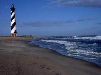
Historic Cape Hatteras Lighthouse Site
Quick Facts
Location:
Buxton, NC
Significance:
National Engineering Landmark
Amenities
4 listed
Beach/Water Access, Historical/Interpretive Information/Exhibits, Restroom, Trash/Litter Receptacles
This is the location where the Cape Hatteras Lighthouse stood from 1870 to 1999.
In 1999, the Cape Hatteras Light Station, which consists of seven historic structures, was successfully relocated 2,900 feet to the west from this spot. Because of the threat of shoreline erosion, a natural process, the entire light station was safely moved to a new site where the historic buildings and cisterns were placed in spatial and elevational relationship to each other, exactly as they had been at the original site. While the National Park Service has met its obligation to both historic preservation and coastal protection, the much-heralded move of the historic station, especially the lighthouse, was hotly debated and closely watched.
Now, the nearby beaches are a popular spot for surfing.
Retreat from the Sea
The scene in front of you marks where the Cape Hatteras Lighthouse stood. Although built to withstand hurricanes, the lighthouse was no match for the encroaching Atlantic Ocean.
Barrier islands, like Hatteras Island, move. Storms, wind, and water cause the island's ocean coastline to naturally migrate westward. Although the island moved, the lighthouse stayed in the same place. Efforts to shore-up the beach and keep back the sea, such as groins and sandbags, didn't help and often made things worse. Sea level rise compounded the issue.
Eventually the ocean was within 60 feet of the tower and, to best protect the lighthouse, the National Park Service decided to move it inland. In 1999, the tower and its adjacent buildings were lifted and moved 2,900 feet to the southwest. With this retreat from the sea, the Cape Hatteras Light Station sits safely behind you...for now.
Encroaching Sea
When completed in 1870, the Cape Hatteras Lighthouse was located a safe 1,500 feet from the ocean. Even then, however, storm-driven tides completely washed over Hatteras Island, eroding sand from the ocean side of the island and depositing it on the sound side. By 1970, this process, which has caused the gradual westward migration of the Outer Banks for at least the past 10,000 years, left the lighthouse just 120 feet from the ocean's edge and almost certain destruction.
The key to preserving the 1870 tower is its "floating foundation." Yellow pine timbers sat in fresh water on compacted sand, with a brick and granite foundation on top of them. This foundation was built because pilings could not be driven through hard sand located barely 8 feet below ground level when construction began. As long as the sand surrounding the foundation remained in place, and the timbers remained bathed by the fresh water in which they were placed in 1868, the foundation was secure. If a storm eroded the sand or the fresh water was disturbed by salt water intrusion, the timbers would rot and the foundation would eventually fail.
Protection Attempts
Since the 1930s, efforts were made to protect the lighthouse from the encroaching sea. The US Coast Guard installed the first sheetpile groins (walls built perpendicular to the shore) to try to protect the tower. In 1936, however, they temporarily abandoned the lighthouse to the sea and moved the light to a skeleton steel tower in Buxton Woods. In the 1960s and 1970s, as the ocean continued to creep closer, various attempts to stabilize the coast included beach nourishment and three new groins installed north of the lighthouse.
A severe storm in 1980 accentuated the island's westward movement, washing away the foundation of the first (1803) lighthouse, which had been 600 feet south of the existing lighthouse. In 1803, that lighthouse had been one mile from the shoreline!
Also in 1980, the National Park Service (NPS) began planning, under the National Environmental Policy Act, for long-term protection. A three-year process that included public meetings yielded several alternatives. Relocation was considered but quickly discounted as impractical. The option finally selected was a concrete and steel seawall revetment that would have protected the lighthouse in place, but would eventually have created an island as the coastline receded to the southwest. As moving technology advanced during the decade and additional information became available about relocation versus the approved seawall, the National Park Service examined the alternative that allowed it to accommodate natural processes while still preserving the historic structures of the light station.
In 1987, NPS requested the assistance of the National Academy of Sciences, a group of scientists and engineers who advise the federal government on technical matters. The Academy's 1988 report, Saving Cape Hatteras Lighthouse from the Sea: Options and Policy Implications , considered ten options but recommended relocation as the most cost-effective method of protection. NPS also considered this the best overall solution in that it would preserve the structures and accommodate the natural shoreline processes.
However, many people feared the lighthouse's destruction if moved improperly. From 1988 to 1995, the relocation option was debated and discussed, with no funding requests made at the Congressional level or concerted fund-raising campaigns undertaken in the private sector. As Federal budgets became leaner, NPS employees worked with the US Army Corps of Engineers on a short-term (10 to 20 year) protection option to build a fourth groin south of the lighthouse. Officials hoped that it would protect the most vulnerable section of the lighthouse area, and would give time to raise federal funds for relocation. However, North Carolina Coastal Resources Commission staff stated that it would not recommend a permit for building the fourth groin since placing any hardened structures on the North Carolina coast is prohibited by state statutes.
In 1996, North Carolina State University independently reviewed the National Academy of Sciences' report and then issued its own report, Saving the Cape Hatteras Lighthouse from the Sea , in January 1997. It not only endorsed the National Academy of Sciences' findings, but also recommended that "the National Park Service proceed as soon as possible with its present plans to obtain the financial resources necessary to preserve the lighthouse by moving it." NPS managers then initiated a concerted effort to begin the planning and funding process to move the Cape Hatteras Lighthouse. Funding was finally appropriated by Congress beginning in fiscal year 1998.
Moving the Lighthouse
The decision to relocate the Cape Hatteras Light Station was a sound public policy decision based on the best science and engineering information available. International Chimney Corporation of Buffalo, New York was awarded the contract to move the lighthouse, assisted, among other contractors, by Expert House Movers of Maryland. In simple terms, the concept of moving the 4,830-ton structure consisted of lifting it off its foundation, transferring the load to a transport system, moving the tower along a prepared move route, and installing it on the new foundation.
To accomplish this feat, the original foundation down to the pine timbers was replaced by temporary shoring beams and supports. Then a steel beam mat was inserted over the timber mat with temporary posts on top. As cross beams and main beams were set, the temporary shoring parts and beams were removed. Hydraulic jacks built into the main beams were used to effect the 6 foot rise so that roll beams and rollers could be introduced. After all jacks were shored, using oak cribbing, the system was pressurized and the jacks began lifting. At each lift level, jacks were retracted and shored up in sequence and the system lifted again to 6 feet. At this point it was ready to roll.
After it was lifted, the tower moved along to its new location 2,900 feet to the southwest on steel mats starting on June 17, 1999. Steel track beams became rails and roller dollies permitted the support frame to move along the track. Three zones of hydraulic jacks kept the lighthouse aligned. Push jacks, clamped to the track pulled the frame forward 5 feet at a time. The lighthouse was equipped with sixty automated sensors to measure the transfer of the load, tilt, vibration, and shaft diameter. A weather station was installed at the top to monitor wind speed and temperature.
The Principal Keeper's Quarters, Double Keepers' Quarters, oil house, cisterns, and sidewalks, which were moved during February, March, and April, awaited the lighthouse. On July 9, 1999 the lighthouse was carefully placed onto its new foundation, which consists of a 60' x 60' steel-reinforced concrete slab 4 feet deep, 5 feet of brick, and 1 1/2 to 2 feet of rock. The light station was whole once again with all the buildings being in the same relative position as they were originally.
The Cape Hatteras Lighthouse, sentinel of the perilous Diamond Shoals, where the Gulf Stream meets the Labrador Current, witness to the tragic sinking and triumphant rescues claimed by the "Graveyard of the Atlantic," resumed its duties on November 13, 1999 and continues to do so to this day. Now safely 1,500 feet from the ocean, it should not be threatened by the indomitable ocean waves for another 100 years.
Move at a Glance
- Over a year of preparation work
- Moved 2,900'
- Moved in just 23 days... from June 17, 1999 to July 9, 1999!
- Moved using horizontally mounted hydraulic jacks which pushed the tower along a track system in 5-foot increments
- After the tower was pushed approximately 5 feet, the jacks were retracted and reset along the grid beams
- Cost $11.8 million
- Set back approximately 1,500' from the shoreline