|
At Monocacy, a Geographic Information System (GIS) has become an integral part of archeology projects conducted on the battlefield. The archeology team has used the GIS in a variety of ways, including planning of field methods appropriate to specific locations, mapping and visually reviewing the results of excavations, and analyzing the relationship of artifacts to each other and to the landscape. 
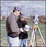
The Monocacy GIS The Monocacy GIS includes several components such as equipment to collect spatial data in the field (survey equipment known as a total station and a data collector), an office computer suite, computer-aided design software, database software, and GIS software. Data includes survey points for cultural and natural landscape features, archeological units, and scanned paper files such as field notes, aerial photographs, and archeological unit photographs.

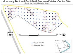
Using the GIS for Projects For each project, a central location is chosen and starting coordinates are located or created for survey. Cultural features (such as buildings, roads, road traces, utilities, etc.) are recorded along with natural landscape features (such as trees, field boundaries, elevations, etc.) to create a project base map. Then, based on project goals, the area to be surveyed is reviewed in the GIS for appropriate archeological field survey techniques and the appropriate units are laid out on the computer. Coordinates are derived from the GIS and the survey equipment is used to "set out" the archeological units in the field. Once the excavations are completed, features and other pertinant data are recorded and mapped in the GIS along with artifact locations. Attribute data for each artifact and feature are placed in a database which may then be used to analyze the spatial relationships among the artifacts. From this data, analysis is performed for creating research reports and maps for showing how the cultural landscape is laid out. |
Last updated: June 9, 2020
