|
Return to River of History. Early Native American Life in the MNRRA CorridorDrew M. Forsberg, M.S. • Hemisphere Field Services, Inc. 
By archaeological accounts, Native American history in Minnesota spans some 12,000 years (Figure 1). During this time, the Mississippi River and its valley became important to Native American peoples, providing plant and animal resources, shelter, and an important route for transportation and trade. This chapter examines Native American history in the MNRRA corridor beginning with the earliest occupants and ending with the coming of European explorers and traders. Written records help document Native American history over the last 350 years. European and American explorers and fur traders left accounts that provide details about Native American history and lifeways. Archaeological excavations of villages, trading posts, forts, and human burials add to this written record. However, written records extend back only as far as the mid-1600s. The long history of Native Americans that predates contact with Europeans and Americans must be reconstructed from archaeological information and, when possible, from oral histories preserved by modern Native American peoples. Because archaeological data pertaining directly to the MNRRA corridor is limited, it is necessary to look at a broader region of Minnesota when discussing pre-contact Native American history. Archaeological information for the earliest periods is sparse, making it necessary to draw inferences from far afield.1 Early Native American Contexts within the MNRRA CorridorPaleoindian Tradition • Humans probably began occupying the MNRRA corridor as the last glaciers retreated. As the ice sheet of the Des Moines Lobe melted, a new landscape emerged and communities of plants, animals, and humans colonized it. Initially, tundra vegetation covered this landscape, but as the climate warmed, a boreal forest dominated by spruce moved north to replace the tundra ecosystems. Humans most likely followed the spread of plants and animals northward.2 Archaeologists generally refer to the earliest Americans as Paleoindians. In other parts of North America, where archaeologoists have excavaated earoy sites, they have identified patterns in lifeways nad marterial culture over time and space. However, because few Paleoindian sites have been identified in Minneostao and even ferwer have been excavated, our kolwedge o fthis period is limnited. The Paleoindian tradition is usually divided into two periods: Early (12,000-10,000 years before present [B.P.]) and Late (10,000-8,000 years B.P.).3 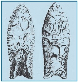
Fluted points have been found in or near the MNRRA corridor (one in Anoka County and seven in Hennepin County).5 However, amateur collectors found most of these artifacts on the surface of cultivated fields, and information on the exact location and circumstances of discovery is meager. One point reportedly comes from the MNRRA corridor (Figure 2). In 1941 a collector discovered a Clovis-like fluted point “eroding from a high bank of the Mississippi River just south of the Washington Avenue Bridge” in Minneapolis.6 While these finds indicate that Native Americans used the MNRRA corridor during Early Paleoindian times, nothing is known of the extent of their occupation and little of their specific lifeways. Late Paleoindian (10,000-8,000 years B.P.) • Cultural changes that coincided with climatic and subsequent environmental shifts mark the Late Paleoindian period. As the glaciers left, the climate warmed. By about 10,000 years B.P., forest vegetation covered much of Minnesota, except for the western part. In southeastern Minnesota, oak, maple, elm, and ash dominated the forest, whereas a pine forest covered central Minnesota. A trend toward a warmer and drier climate and the northeasterly expansion of prairie vegetation characterize the subsequent millennia. By about 8,000 years B.P., the prairie/forest border had advanced into east central Minnesota. In general, lifeways during the Late Paleoindian period initially resembled those of the Early Paleoindian period. Late Paleoindian peoples moved frequently and depended upon hunting. However, as communities of plants and animals changed in response to the changing climate, so too did the humans that relied on them for subsistence. As the mammoth, camel and other megafauna that flourished during glacial and immediately postglacial times became extinct, the Late Paleoindian peoples increasingly turned to other quarry. In the prairie regions of North America, bison became the primary food, although Native Americans undoubtedly consumed smaller animals and various plants as well. 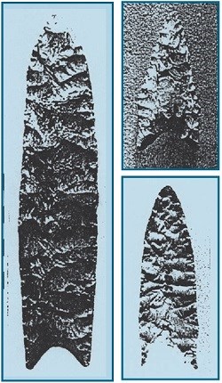
Recognition of the Late Paleoindian period is most often based on the presence of distinctive, finely crafted projectile points made from high quality stone. These points were lanceolate but lacked the pronounced fluting seen in Early Paleoindian specimens. Rather, their makers removed narrow flakes from both faces in parallel patterns. Late Paleoindian points display greater variation in form, and archaeologists have identified many distinct types, such as Alberta, Cody, Agate Basin, and Scottsbluff. Late Paleoindian sites in Minnesota are rare, and few have been excavated. Only two have yielded radiocarbon dates: the Brown’s Valley site (21TR5), located in Traverse County in western Minnesota, and the Bradbury Brook site, located south of Mille Lacs Lake in east central Minnesota.7 Human bone from the Brown’s Valley site was radiocarbon dated to about 9,000 years B.P., whereas a piece of charcoal from a pit feature at the Bradbury Brook site was radiocarbon dated to about 9,200 years B.P.8 A recent survey of literature and collections indicates that Late Paleoindian points have been found throughout Minnesota.9 Most are surface finds, often picked up by collectors, who recorded the locations imprecisely or not at all. Although a moderate number of points have been found in or near the MNRRA corridor, most came from uplands well away from the Mississippi River.10 However, archaeologist T. H. Lewis discovered several points in the late 1800s on the floodplain across from downtown St. Paul (Figure 3).11 He did not record the exact location(s) where he found these artifacts, and no State site number exists. Recently, archaeologists recovered a Late Paleoindian point during excavations at the Sibley House/American Fur Company site (21DK31) near Mendota, but they discovered no other Late Paleoindian materials. Native Americans clearly lived in the area during Late Paleoindian times, but until someone finds a well-preserved site, nothing substantial can be said about the people of this period. Archaic Tradition (8,000-2,500 years B.P.) • During Archaic times, Minnesota’s occupants continued to adapt to ongoing changes in climate and vegetation. The trend toward a warmer and drier climate that began about 9,000 years B.P. continued, accompanied by the northeasterly expansion of prairie vegetation. By about 6,000 years B.P., prairie covered much of Minnesota, including the entire MNRRA corridor. Lake levels in the region fell, and substantial sand dunes spread in the Anoka Sand Plain region, located just east of the Mississippi River in Anoka County. After about 6,000 B.P., the climate gradually became wetter . In response, forests pushed the prairie to the southwest. The forest-prairie border reached its present location by about 3,000 years ago.12 In general, changes in subsistence and settlement patterns differentiate the Archaic tradition from the preceding Late Paleoindian period. Archaic peoples became somewhat more sedentary, as they learned to use more diverse plant and animal resources for subsistence, and their tool technology changed and diversified. They used grinding stones to process plant foods, and they made tools from metamorphic or igneous rocks for cutting and chopping wood. In addition, by about 7,000 years B.P., Archaic peoples began to develop a copper tool technology, using pieces of native copper mined from the Lake Superior region or found locally in glacial drift. They fashioned knives, projectile points, gouges, other tools, and decorative items from copper. In the past, archaeologists thought that copper artifacts from the Midwest represented part of an “Old Copper” industry dating to later Archaic times (ca. 5,000-3,000 years B.P.). However, archaeologists now recognize evidence that Native Americans used copper before and after this period. No copper artifacts have yet been recovered from sites located in the MNRRA corridor. As with the Paleoindian tradition, the form and composition of stone projectile points provide information about Archaic lifeways. The narrower distribution and greater diversity of projectile point styles may indicate an increase in regionalism. Innovations in hafting technology (how Native Americans attached their points) are evident in the change from lanceolate points to points that were notched or stemmed at the base. Archaic points lack the finely executed, parallel flaking seen in Late Paleoindian specimens, and the craftsmanship declined or became less important. In addition, Archaic peoples relied more upon stone procured from local sources, which was often inferior to materials used during preceding periods. In parts of the Midwest where greater numbers of Archaic sites have been identified and excavated, archaeologists divide the Archaic tradition chronologically into three periods: Early, Middle, Late. However, known Archaic sites are rare in Minnesota, and it has not yet been possible to assign this chronology to the region with any confidence. Moreover, because the environment influenced the lifeways and material culture of Archaic peoples, there are differences in the subsistence/settlement strategies and toolkits of inhabitants of the western prairie, the deciduous forests of the eastern woodlands, and the northern boreal forests of the Canadian shield. Excavations of Archaic sites in western Minnesota at the Itasca Bison Kill site, in Itasca County, and the Canning site, in Norman County, indicate a subsistence pattern that focused on hunting bison but also exploited smaller animals and plant foods. Farther to the east, in areas that were continuously forested during Archaic times, a different adaptive pattern is evident. Here, subsistence focused on riverine resources (like fish and freshwater clams), nuts and deer. Because the environment of the MNRRA corridor changed dramatically during the Archaic (from forest to prairie, and back to forest again), it is likely that adaptive strategies changed as well.13 Few Archaic sites have been identified and excavated in eastern Minnesota. Those few sites that are known generally date to the later portions of the Archaic period. The Petaga Point site (21ML11), located just south of Mille Lacs Lake, contains an Archaic component.14 While the artifacts recovered from this component resemble types seen at sites from the same period in the Great Lakes region and the upper Mississippi River valley, the site lacked good information on the lifeways of the site’s Archaic inhabitants. The St. Croix River Access site (21WA49), on the St. Croix River in Washington County, just east of the MNRRA corridor, yielded evidence for two separate episodes of occupation during Archaic times.15 The site’s occupants manufactured tools from stone taken from nearby bedrock outcrops. Animal remains present at the site indicate that they consumed white-tailed deer and beaver.16 The King Coulee site (21WB56), located at Lake Pepin, includes a Late Archaic component.17 Archaeological evidence from the site indicates that its inhabitants focused on riverine animals, although nuts and seeds were important. Most significantly, archaeologists obtained a radiocarbon date from a domesticated squash seed excavated from an Archaic horizon at the site, providing evidence for the earliest use of domesticated plants in the upper Mississippi River valley. At present, it is unknown whether the lifeways practiced at the Archaic sites mentioned above extended into the MNRRA corridor. Although three sites within the MNRRA corridor are thought to have Archaic components, including the Lee Mill Cave (21DK2), Ranelius (21DK4), and Sibley House/American Fur Company (21DK31) sites, little information is available. The Archaic component at the Lee Mill Cave site consisted only of a fire pit that contained fish bones. No artifacts were associated with the fire pit, and its affiliation with the Archaic period was determined solely because it was located below a Woodland component. Further characterization of the Archaic occupation of the MNRRA corridor must await the identification and excavation of additional sites.18 Woodland Tradition (2,500-350 years B.P.) • Several new technologies and activities characterize the Woodland tradition. The introduction of pottery and the construction of earthen mounds for burial of the dead are hallmarks of this period. Initially, few changes in lifeways accompanied the Archaic-Woodland transition, but a trend toward more sedentary settlement patterns and the intensification of horticulture characterizes this era. Within the MNRRA corridor, it is likely that Native American peoples continued to rely on riverine resources for their subsistence.19 During the Woodland era, the climate continued moving toward current conditions. Prairie vegetation decreased while forest vegetation (pine and oak) increased, and the prairie/forest border reached its present location. Lake levels rose across the region in response to cooler and moister conditions. Although the climate was relatively stable over the long term, several short-term fluctuations occurred. Between about 1,000 and 500 years B.P., temperatures increased. This warmer period, known in other parts of the world as the Medieval Warm Period, corresponds to the emergence of maize horticulture and intensification of wild rice use among Minnesota’s Native American peoples. At least two episodes of cooler and moister conditions occurred as well: one from 1,600 to 1,400 years B.P. and the other from A.D. 1550 to 1850. It is likely that the Little Ice Age affected Minnesota’s Native Americans, especially those who relied upon horticulture. In any case, during the cooler and moister conditions of the Little Ice Age, the forested area expanded south from east central Minnesota to create the so-called Big Woods. Early Woodland (2,500-2,000 years B.P.) • The Early Woodland period is poorly known in Minnesota. Elsewhere in the Midwest, the period is marked by an increased focus on riverine resources and the use of domesticated plants. Early Woodland peoples first began to manufacture and use pottery, which initially was heavy and thick-walled. In addition, they began to bury their dead in large conical earthen mounds, which often possessed internal structures or chambers built of rock or logs. Projectile points from this period are often straight-stemmed. In Minnesota, few Early Woodland sites have been identified, and most of these lack radiocarbon dates. The most famous Early Woodland site in the region is the La Moille Rockshelter (21WN1), located in the Mississippi River valley downstream from the MNRRA corridor. This site, probably a fishing camp, yielded a ceramic vessel that strongly resembles Early Woodland ceramics found in Ohio, Indiana, Illinois, Michigan, and Kentucky. The vessel is thick-walled (10-15 mm) with a flat lip, and its exterior was cord-roughened and decorated below the rim with rows of circular punctuations and fingernail impressions. The clay used to construct the vessel was tempered with crushed stone or grit. At the King Coulee site (21WB56), on Lake Pepin, archaeologists recovered similar thick-walled ceramics. As at the La Moille Rockshelter, fishing seemed to be the primary subsistence activity, although the remains of other animals (mammals, birds, reptiles, and shellfish) were present. Moreover, King Coulee’s Early Woodland inhabitants ate nuts and seeds.20 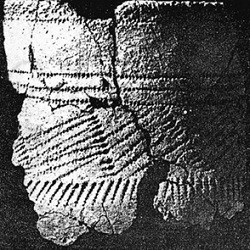
The Schilling site (21WA1), located on the eastern tip of Lower Grey Cloud Island, is the only known Early Woodland site recorded in the MNRRA corridor. Excavations at the site yielded thick-walled ceramics (Figure 4) that are similar to those recovered from the La Moille Rockshelter and the King Coulee site. During the Early Woodland, the site was probably inhabited during the summer. Its inhabitants ate various mammals and birds. Interestingly, despite the site’s setting and despite the apparent importance of fishing at other Early Woodland sites, fish remains are absent from the Schilling site.21 Middle Woodland (2,000-1,500 years B.P.) • During Middle Woodland times, complex cultures developed along the Ohio, Illinois, and Mississippi River valleys. These cultures are best known for the appearance of sophisticated mound and mortuary centers, long-distance trade in exotic raw materials (copper, marine shell, and obsidian), increased population density, and the first use of corn as a cultigen in eastern North America. The major Middle Woodland centers were in Ohio and Illinois, although evidence of Middle Woodland influence occurs at many sites in the midcontinental region. Although archaeologists are debating how to interpret Middle Woodland culture, they agree that it represents a major florescence. In Minnesota, the influence of eastern Middle Woodland groups is most apparent on the Anoka Sand Plain. The region contains the most northerly Middle Woodland center, which is represented by the Howard Lake phase. Numerous sites containing Middle Woodland materials related to the Havana Hopewell complex of Illinois have been identified. The large number of Middle Woodland sites in the Anoka Sand Plain indicate that it was an important population center, and several large conical burial mounds are present in the area. Howard Lake ceramics are quite similar to the Havana Hopewell materials of Illinois, and artifacts made of exotic raw materials, particularly copper, have been found in this area. The Howard Lake phase appears to parallel the rise and subsequent decline of the Middle Woodland culture farther south and east. Evidence for a Middle Woodland presence has also been found south of the Anoka Sand Plain, along the Mississippi River. A number of sites in the MNRRA corridor show Hopewellian influences. Most dramatically, several large, conical burial mounds at the Indian Mounds Park (21RA10), in St. Paul, were excavated in the nineteenth century, revealing burials interred in log tombs and limestone cists. Grave goods included exotic items typical of Hopewell burials, such as platform pipes carved from stone, ornaments hammered from sheets of copper, and a clay death mask. Unfortunately, nearly all the artifacts excavated from this site have disappeared. 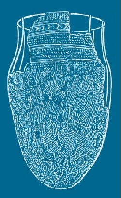
Hopewellian influences are also seen, albeit less dramatically, at several habitation sites a short distance downstream. These sites, exemplified by the Sorg site (21DK1), yielded ceramics stylistically similar to Havana Hopewell specimens (Figure 5). The decorative traits of the Sorg ceramics are similar to those seen on Howard Lake ceramics; however, the chronological and cultural relationships between Howard Lake and Sorg are not understood. The presence downriver, in Trempealeau County in western Wisconsin, of other sites showing Havana Hopewell influence suggests that ideas and technology may have traveled from Illinois via the Mississippi River. With sites extending from the Anoka Sand Plain to Spring Lake, near Hastings, the Middle Woodland peoples clearly used the Mississippi through the MNRRA corridor.22 Middle to Late Woodland Transition (1,600-1,100 years B.P.) • At the close of the Middle Woodland, following the decline of the Havana Hopewell influence, a transitional phase occurred. This transition was expressed somewhat differently in east-central and southeastern Minnesota. In each region, certain Middle Woodland traits persisted (ceramic styles and conical burial mounds), but distinct regional lifeways developed. EAST-CENTRAL MINNESOTA • The hallmark of this transitional period in east central Minnesota is the growing importance of wild rice as a food staple. Projectile points became smaller and triangular, suggesting that Native Americans used the bow and arrow. This new, more effective weapon allowed Native Americans to concentrate on a few species of large animals, such as deer or bison. These developments suggest that Native Americans developed a more focused subsistence strategy, and perhaps as a result of these changes in subsistence, the Native American population increased across the region.23 In east central Minnesota, the St. Croix phase represents the Middle to Late Woodland transition. St. Croix habitation sites are typically located near lakes good for wild rice, fishing, and waterfowl hunting. Projectile points associated with the St. Croix phase are finely made isosceles triangular points or side-notched points. Grit-tempered vessels, with cord-roughened surfaces, characterize St. Croix series pottery. Decorations consist of simple geometric designs made with a dentate stamp, a comb stamp, or a stick finely wrapped with cord. The Onamia series is a second ceramic type associated with the Middle to Late Woodland transition and may postdate St. Croix ceramics. Onamia ceramics are similar in form and surface treatment to St. Croix ceramics. However, the two types differ in decorative styles. Onamia ceramics are distinguished by loosely wound, widely spaced, cord-wrapped stick impressions, whereas dentate and comb stamping are less common decorative traits. No St. Croix/Onamia sites are currently recorded for the MNRRA corridor. The majority of sites with St. Croix and/or Onamia components are located in the lake region of east central Minnesota. However, sites with St. Croix and/or Onamia ceramics are often found near the MNRRA corridor, at lakes in the uplands of Anoka, Dakota, Hennepin, Ramsey, and Washington Counties. Moreover, sites occasionally lie within the St. Croix valley and elsewhere in the Mississippi valley. For example, the St. Croix Access site (21WA49) yielded St. Croix ceramics. Given the proximity of so many St. Croix/Onamia sites, it is possible that sites of that affiliation will be discovered along the MNRRA corridor. SOUTH EASTERN MINNESOTA • During the Middle to Late Woodland transition, inhabitants of southeastern Minnesota continued to use riverine food resources, as in the preceding periods, but increased their use of domesticated plants. A horticultural economy, focused on squash, sumpweed, and starchy seeded plants (goosefoot and knotweed), began to emerge. Ceramic vessels became slightly thinner, although the use of grit temper and Havana Hopewell decorative traits (dentate stamping) continued. The La Crosse area has well-known sites dating from this period. The previously mentioned King Coulee site at Lake Pepin contains a Middle Woodland/Late Woodland Transition component; however, it lacked detailed subsistence data. No one has discovered a site from this transi- tional period in the MNRRA corridor. Still, some potential exists that sites will be identified, particularly in the corridor’s southern reaches.24 Late Woodland (1,350-300 years B.P.) • During the Late Woodland period, lifeways differed significantly in east central and southeastern Minnesota. Environmental differences between the two areas may account for much of this difference. EASTCENTRAL MINNESOTA • In the “lakes district” of east central Minnesota, the Kathio/Clam River phase represents the early Late Woodland period. During this phase, the trend toward the more focused subsistence practices continued. Increasingly, Native Americans relied on the harvesting of wild rice and the hunting of deer and other small mammals. An increase in the size and number of sites indicates that their population was rising. In general, these sites lie near shallow lakes or streams where wild rice would have been plentiful. Projectile points from this period are small, triangular points that are sometimes notched, reflecting the continued use of the bow and arrow. The Kathio and Clam River pottery, which are closely related, are similar to the preceding St. Croix and Onamia ceramics in terms of temper, surface treatment, and decorative traits. However, these Late Woodland vessels are more globular, and their walls are somewhat thinner. These trends indicate a gradual evolution of ceramic manufacturing techniques and decorative styles.25 No sites with Kathio/Clam River components are recorded in the MNRRA corridor. Kathio and Clam River sites are more frequent north of the MNRRA corridor but do appear in the uplands of Anoka, Hennepin, and Washington Counties away from the Mississippi River valley. As with the preceding St. Croix/Onamia phase, there is some potential for the existence of sites with Kathio/Clam River components in the MNRRA corridor, particularly in its northern reaches. Around 1,000 years B.P., a new pottery type, called Sandy Lake, suddenly replaced the Kathio/Clam River ceramic series across central Minnesota. Sandy Lake ceramics are thin-walled, have cord-roughened or smooth surfaces, and are tempered with grit or crushed shell. Decoration is rare. When present, it usually consists of simple notching around the rim. Lifeways in the Sandy Lake phase resembled those of the preceding Kathio/Clam River phase, although Native Americans developed techniques for roasting and storing wild rice during this period. Archaeologists interpret the sudden advent of Sandy Lake ceramics as evidence of the arrival of a new people, perhaps the Eastern Dakota, who displaced the earlier Woodland population. Sandy Lake sites are concentrated in central Minnesota, but the ceramics are found occasionally at sites to the south. For example, a few shards of Sandy Lake pottery were recovered from Late Woodland levels at the St. Croix Access site (21WA49). Interestingly, ceramics that resemble Oneota materials (see below) are sometimes found at Sandy Lake sites, suggesting some level of contact and/or trade between the inhabitants of central and southeastern Minnesota. SOUTH EASTERN MINNESOTA • In the riverine environment of southeastern Minnesota, the Late Woodland has unique characteristics. Most notably, Native Americans here did not use wild rice as much. Wild rice was present in some areas along the Mississippi River, but not in enough quantities to serve as a major food resource. Instead, inhabitants of the region began to practice horticulture intensively. In addition to domesticated plants (squash, sumpweed) grown during the preceding period, corn and beans became increasingly important. As with wild rice to the north, use of corn may have stabilized seasonal subsistence patterns, allowing for more sedentary settlement and greater population growth. Because of climatic factors, corn cultivation was generally limited to southern Minnesota, and corn was not widely available to the more northerly peoples of east central Minnesota. Other distinct cultural traits emerged during the Late Woodland in southeastern Minnesota. Although construction of conical burial mounds probably continued, a new mound form emerged. Native Americans here built so-called “effigy” mounds in the shape of familiar animals, such as snakes and bears. The most famous mound group of this type occurs at Effigy Mounds National Monument, on the Mississippi River in northeastern Iowa. Projectile points from this area are small and triangular, with both notched and unnotched bases. Three Late Woodland ceramic types are known in southeastern Minnesota: Nininger Cordwrapped Stick Impressed, Bremer Triangular Punctated, and Madison Plain (Figure 6). In general, vessels are thin- walled and wide-mouthed with cord-roughened surfaces.26 Late Woodland sites of the southeastern Minnesota type appear in the MNRRA corridor in Dakota and Washington Counties. Several sites possessing Late Woodland components are near Spring Lake. Nininger Cord-wrapped Stick Impressed ceramics were first identified at the Sorg site (21DK1). Although a variety of lithic artifacts were present (triangular points, scrapers, knives, drills), subsistence data were lacking from the site’s Late Woodland component. Similarly, Bremer Triangular Punctated was first defined at the Bremer Village site (21DK6). Other sites in the MNRRA corridor with similar Late Woodland materials include the Lee Mill Cave (21DK2), the Hamm (21DK3), and the Sibley House/American Fur Company (21DK31) sites. 27 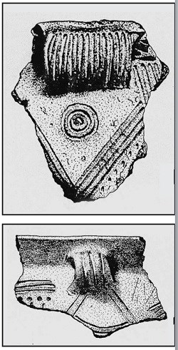
Oneota Tradition (1,000-300 years B.P.) • Beginning about 1,000 years ago, a new cultural tradition known as “Oneota,” emerged in the upper Mississippi River valley. Oneota probably represents Woodland peoples influenced by the ideas and lifeways of the Mississippian tradition, which arose to the southeast along the middle Mississippi River. In southeastern Minnesota, Oneota peoples were present until the first Euro-Americans arrived in the mid-1600s. The Oneota presence was more limited in east central Minnesota, including the MNRRA corridor. In this region, it appears that the Late Woodland tradition continued until first contact with Euro-Americans. In Minnesota, the Oneota tradition appears to emerge near Red Wing and Lake Pepin between about 1,000 and 800 years B.P. Subsequently, clusters of Oneota villages spread to the La Crosse area and the Blue Earth River valley in south central Minnesota (Blue Earth Oneota), the river valleys of southeastern Minnesota (Orr Focus Oneota), and portions of central and southeastern Iowa. The Oneota subsisted on a wide variety of plants and animals. Most significantly, they practiced horticulture, cultivating corn, beans, squash, and other domesticated plants in gardens on river floodplains. They lived in villages on river terraces overlooking rich floodplain, although they established temporary camps associated with hunting and gathering of wild plants in upland locations. Oneota villagers sometimes erected protective walls or palisades. Oneota society was segmented by clan affinities. Oneota ceramics display variation in form and decoration, but in general, vessels are smooth-surfaced and tempered with crushed shell (Figure 7). Oneota peoples used a rich suite of bone and chipped and ground stone tools. They also made pipes carved from pipestone or ornaments fashioned from shell, bone, or copper. Although Oneota sites are concentrated in southern Minnesota, evidence for an Oneota presence in the more southerly portions of east central Minnesota has been found at several sites. In addition, the presence of ceramics with Oneota affinities (Ogechie ceramics) at Sandy Lake sites in central Minnesota suggests that there was some contact between the Oneota and more northerly peoples. Within the MNRRA corridor, Oneota components have been identified at the Schilling site (21WA1), the Lee Mill Cave site (21DK2), the Point Douglas Townsite (21WA54), and the Grey Cloud Mounds site (21WA9). Evidence suggests that these sites were probably temporary camps occupied when Oneota peoples ventured north from their permanent village settlements to hunt for food or to trade. The Oneota component at the Lee Mill Cave site contains ceramics that resemble those found on Oneota sites in the Blue Earth River valley. The best excavated Oneota site in this region is the Sheffield site (21WA3), on the St. Croix River south of present-day Marine on St. Croix. Oneota peoples used this site as a seasonal hunting and fishing camp some 700 years ago. No evidence of agriculture was found. As at the Lee Mill Cave site, the ceramics recovered from the Sheffield site resemble Blue Earth Oneota types. Interestingly, the site also contained Woodland components that predated, postdated, and were contemporaneous with the Oneota occupation. The relationship between the more southerly Oneota peoples and the Woodland peoples to the north is not well understood at present.28 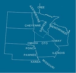
Contact and Post-Contact PeriodsWhen Europeans first entered the Midwest in the mid-1600s, several different Native American groups occupied Minnesota (Figure 8). By that time, European settlement in the East had forced some tribes west, resulting in a distribution of tribes different from what it had been a century before. In some cases, archaeologists have been able to link tribes present in the area in the 1600s to earlier peoples known only through archaeological data. In other cases, the link between historic tribes and cultures known only through archaeology is more tenuous. Contact with Europeans brought sweeping changes to Native American society, as Europeans introduced new values, lifestyles, ideas, technologies, and diseases. Chiwere-Winnebago Language Group • When the French entered the area that is now Minnesota and Iowa in the late 1600s, speakers of the Chiwere-Winnebago language group, a subdivision of the Central Siouan language, lived there. These peoples were divided into several groups (including the Ioway, Oto, and Missouri) that were closely related by language, belief, culture, and kinship. Oral histories suggest that these groups had split apart from a common ancetral tribe. In particular, the Ioway and Oto were closely allied, often hunting together. The Winnebago, who lived in eastern Wisconsin, were closely related to the Ioway, Oto, and Missouri, and sometimes hunted with the more westerly tribes. Although the French had heard reports about the Ioway through eastern tribes since the 1650s, the first contact between the two peoples occurred in 1676 at a Winnebago village near present-day Green Bay, Wisconsin. Father Louis Andre described the visiting Ioway in the following manner: “Their village which is 200 leagues from here is very large but poor, since their greatest wealth is in buffalo hides and red stone calumet pipes. They speak the language of the puants [Winnebago].” Subsequently, French explorers and traders ventured to the west, learning that the Ioway occupied southeastern Minnesota and northeastern Iowa, whereas the Oto occupied north central Iowa.29 Initially, the French had traded with the Ioway through the Algonquian-speaking tribes living to the east in Wisconsin and Illinois. However, as the fur trade spread westward, contact between the French and the Ioway became more frequent and direct. The French traded metal items, glass beads, guns, and ammunition to the Ioway in exchange for bison hides, and later, beaver pelts. Direct contact with the Ioway troubled the easterly Algonquian-speaking tribes, particularly the Mascouten. By losing their position as middlemen, these people feared that the Ioway and Oto would get firearms more easily, which would upset the balance of power. An intense intertribal rivalry developed, often resulting in war. By the late 1680s, the Ioway had abandoned their homes in southeastern Minnesota and northeastern Iowa and moved nearer to the Oto in northwestern Iowa. This move, however, did not protect them from their enemies for long. In the 1690s, the Mascoutens apparently pursued the Ioway into northwestern Iowa, attacking and decimating their large village. Subsequently, the Ioway and Oto moved farther to the west. In 1701- 1702, the Ioway moved near Fort L’Huillier on the Blue Earth River in Minnesota at the invitation of French trader Pierre Le Sueur. However, after the fort was abandoned in 1702, the Ioway returned to the southwest. Historic evidence links the Ioway to the archaeologically known Orr Focus Oneota. Orr Focus sites along the Upper Iowa River in northeastern Iowa contain European trade goods, as do several Orr Focus sites in southeastern Minnesota. By comparing historic documents and archaeological data, researchers have determined that the sites in northeastern Iowa corresponded to the Ioway villages visited by French fur trader Nicholas Perrot in 1685. Similarly, the Oto may be related to the Blue Earth Oneota of the Blue Earth River valley near present-day Mankato, although direct evidence is lacking.30 No Ioway or Oto sites are known within the MNRRA corridor. However, if these historic tribes are indeed related to earlier Oneota peoples, they had at least a limited presence. As discussed above, several sites with Oneota components have been documented in the St. Croix and Mississippi River valleys of northern, southeastern and southern, east central Minnesota. In particular, the Lee Mill Cave (21DK2) and Sheffield (21WA3) sites both yielded Oneota ceramics similar to Blue Earth Oneota specimens. Also, some ceramics found at Sandy Lake sites in central Minnesota share affinities with Oneota materials. Thus, it is likely that the people who came to be known as the Ioway and Oto passed through the MNRRA corridor via the major rivers, perhaps on seasonal hunting and gathering trips or on their way to visit other regions and peoples. Eastern Dakota (Santee) • At the time of the first European contact, the Eastern Dakota or Santee inhabited much of Minnesota. The Santee included the Mdewakanton, Wahpeton, Wahkepute, and Sisseton, and lived along and east of the Mississippi River. The Santee were closely related by language and culture to the Yankton and Yanktonai (Nakota), who lived along the Minnesota River upstream from present-day Mankato; the Teton (Lakota), who lived in western Minnesota near Lake Traverse; and the Assinboin, who occupied northwestern Minnesota. Together, these people came to be known to the French as the “Sioux,” which was derived from the Algonquian term “Nadouessiw” meaning “snake” (i.e., “enemy”).31 Early accounts indicate that during the late seventeenth century, the Eastern Dakota had adapted their subsistence and settlement patterns to the environment of the prairie/forest border. They occupied relatively permanent villages in forest areas, for example, near Mille Lacs Lake. From this base, the Eastern Dakota hunted mammals and waterfowl, fished, and gathered shellfish. Intermittently, they traveled to the western prairies to hunt bison, elk, and deer. Wild rice grew plentifully in the shallow lakes of the forest region. The Eastern Dakota also relied on a number of other plant foods, including starchy seeds, tubers, maple sugar, fruits and berries, and nuts. Unlike peoples to the south, the Eastern Dakota did not intensively cultivate corn, beans, or squash (presumably because the climate of east central Minnesota did not favor horticulture). On the basis of written accounts, the Eastern Dakota used tools made of stone and bone, cooked in earthen pots, and buried their dead with grave goods in earthen mounds. Links to earlier known archaeological cultures are tenuous at present. Excavations at village sites and burial mounds near Mille Lacs Lake suggest that the Eastern Dakota had occupied the area for at least several centuries prior to con-tact with the French. During this period, the Eastern Dakota may have produced ceramics of the Sandy Lake variety, which replaced Kathio and Clam River ceramics across central Minnesota rather abruptly about 1,000 years B.P. This sudden appearance of Sandy Lake ceramics may represent the arrival in the region of the Eastern Dakota, who displaced the indigenous Woodland populations. However, archaeologists have not been able to establish a connection between the late prehistoric archaeological cultures and the early historic tribes of northern and eastern Minnesota. Few archaeological sites associated with Eastern Dakota occupation are recorded for the MNRRA corridor. The approximate locations of early nineteenth century communities such as Kaposia or Pine Bend are known, but no archaeological work has been completed at these sites. In the 1980s, the University of Minnesota conducted archaeological excavations at the Little Rapids (21SC27) site, a nineteenth century summer planting village located a short distance up the Minnesota River. Data from the excavations, supplemented by historic records and oral interviews with descendants of the village’s residents, furnished detailed information about nineteenth century lifeways at the village, especially those of its female inhabitants. Archaeologists conducted more limited excavations at the probable location of Black Dog’s village, which the Dakota occupied from about 1750 to 1850. The Dakota Internment Camp, where some 1,500 individuals were held following the Dakota Conflict of 1862, is located in the river bottom below Fort Snelling but has never been investigated archaeologically. Similarly, Pike Island (located at the confluence of the Mississippi and Minnesota rivers) was frequently occupied by the Eastern Dakota but has never been investigated.32 Many significant changes occurred in the lifeways, material culture, and geographic distribution of the Eastern Dakota in the years following their initial contact with the French. It is likely that for at least 100 years before the French arrived, the Dakota had been venturing into the western prairies to hunt bison with increasing regularity. The cooler and moister conditions of the Little Ice Age may have prompted this shift by making subsistence more difficult in the eastern forest regions. But the Chippewa may have forced the Dakota to move, as the Chippewa migrated south and west from the Lake Superior region in response to the fur trade. European and American expansion and the associated tribal migrations intensified Dakota use of the Mississippi River in the MNRRA corridor. For eons, Native Americans had adapted to environmental changes and the movements of other Native American groups. Increasingly, European and American expansion would define Native American lifeways, and in ways as dramatic as the glaciers, transform the river and its ecosystems. Chapter 2 Endnotes
|
Last updated: November 22, 2019
