News Release

|
Subscribe
|
Contact: Mike Klimek, (530) 595-6161
Lassen Volcanic National Park Fire Management Staff plan to initiate a 100 acre prescribed fire project in the Manzanita Lake area during the early to mid-October, pending weather conditions. Ignition is expected to occur over a cumulative 2-3 day period with residual burn down predicted to take place up to 2 week after final ignition operations. The fire will be regularly staffed andmonitored until declared out.
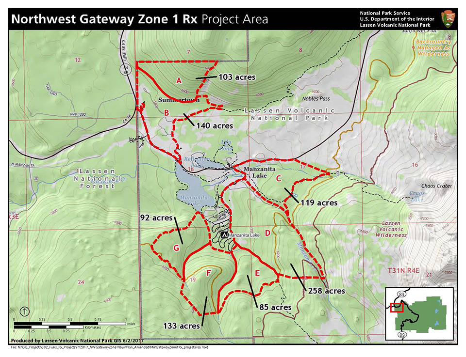
The NW Gateway Zone 1 prescribed fire project area lies at the northwest corner of Lassen Volcanic National Park, CA. along State Highway 89 and 44 in Township 31 North, Range 4 East, Section 7, 17, 18, 19, and 20. The principal meridian for the Public Land Survey System is Mount Diablo. The project area encompasses approximately 865 acres of the Lassen Volcanic National Park Manzanita Lake area and lies amongst and directly adjacent to Park campgrounds, administrative buildings, and residential sites. Also, the project boundary lies adjacent to Lassen National Forest Hat Creek Ranger District. In general, the project area is accessed by multiple Park roads and trail systems, which facilitate segmentation and containment of project activities. We will be focusing our efforts on Unit G for approximately 100 acres (See attached Map).
Over 60% of the project area has received fuel treatments in recent years to help produce more fire resistant and resilient fuel profiles by reducing overall stand density and ladder fuels. The arrangement of fuels consists of low/moderate continuous areas of needle litter and shrub fields with occasional occurrences of heavy dead-and-down logs with patches of grasses and forbs in open sites. In general, the separation between live crowns and surface fuels average 10-20 feet with relatively low/moderate crown connectivity. Fuel Model 8 will be represented in these areas given the expected fire behavior, fuel loading, fuel arrangement, and continuity of fuels. Slow burning ground fires with low/moderate flame lengths are the case, although the fire may encounter an occasional heavy fuel concentration that can cause flare-ups.
We understand the people of Northern California have dealt with poor air quality throughout the 2018 wildfire season. To lessen the overall impacts of smoke on our surrounding communities, prescribed burns allow professionals to work towards reducing hazardous fuels under favorable conditions.
For more information, please contact the park at (530) 595-4480 between 9:00 a.m. and 5:00 p.m. or visit the park website at www.nps.gov/lavo.
Last updated: October 10, 2018
