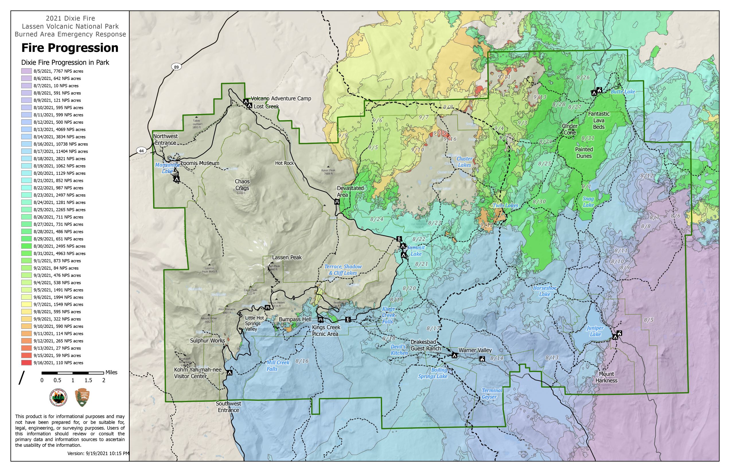
Effects of the 2021 Dixie Fire

A map of the park showing the progression of a wildfire from the southeast corner to the northeast corner.
The Dixie Fire progressed south to north along the eastern side of the park between August 5 and September 16, 2021. Click for larger view.

Largest Fire in Park History

The Dixie Fire footprint includes 73,240 acres within the park. Although this area is 69% of park acreage, more than half of the park was not affected by the fire since the footprint includes nearly 13,000 acres where vegetation remains unchanged.
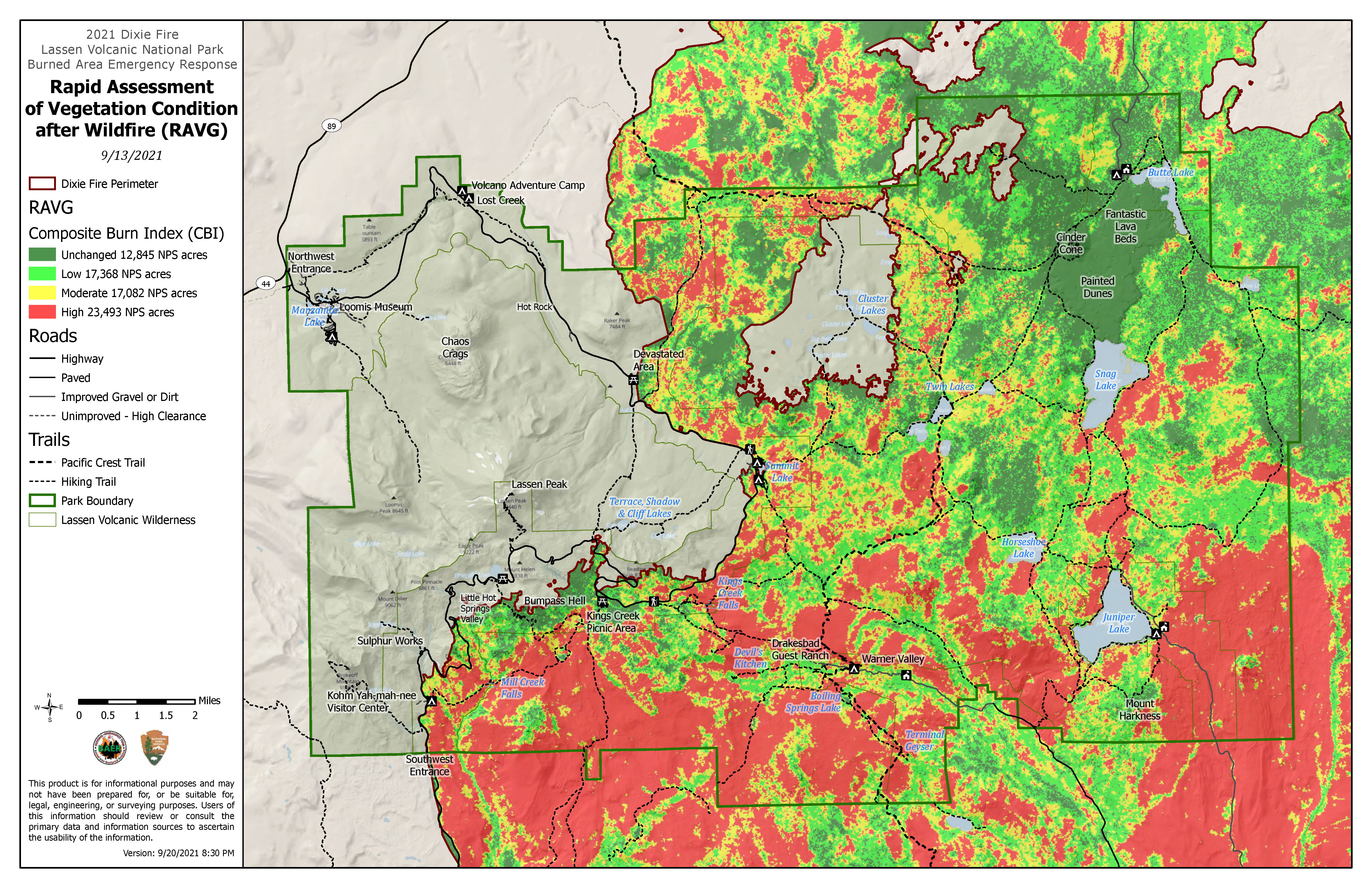
Effects within the park are generally more moderate than within other areas of the fire. However, the fire burned vegetation across 57,943 acres at various levels of severity and damaged or destroyed 12 park structures.

 
A map of the park showing vegetation burn severity in colors red, orange, and green with the southeast corner being predominately red and the northeast corner more green.
Map of vegetation burn severity as of 9/13/2021. Click for larger view.

Effects on Vegetation

The majority of burned areas lay in the eastern portion of the park and were low to moderate severity. One-third of affected areas burned at high-severity, including portions of Mill Creek drainage (below the Southwest Entrance), Warner Valley, and Juniper Lake Area.

Initial Vegetation Burn Severity within Lassen Volcanic

Severity

Acres

Percent of Fire Footprint

Unchanged

12,845

18%

Low to Moderate

34,450

49%

High

23,493

33%


Effects on Infrastructure

Structures and Facilities

High-severity fire activity in the southeast portion of the park resulted in the loss or damage of 12 park structures. While significant, structure loss within the park was limited in part due to previous fire management efforts including fuel reduction and prescribed burn projects. This includes:

  • 2 bungalow units, the annex and a water plant at Drakesbad Guest Ranch in Warner Valley were destroyed.
  • In the Juniper Lake Area, 7 of 8 cabins on the north shore of Juniper Lake, including 1 park-owned cabin were destroyed.
  • The wooden portions of the historic Mt. Harkness Fire Lookout in the Juniper Lake Area were destroyed and the stone base was damaged.
  • Kings Creek Falls overlook were damaged.
  • Mill Creek Falls bridges were destroyed.
 
Two people in yellow shirts, green pants, and hard hats record data of a destroyed structure backed by conifer trees burned by wildfire.
Cultural resource specialists on a Burned Area Emergency Response (BAER) Team survey the destroyed annex building at Drakesbad Guest Ranch in the Warner Valley Area.

NPS

Post-Fire Recovery

Burned Area Emergency Response (BAER) is one part of a of post-fire response that includes fire suppression damage repair, post-fire emergency stabilization and rehabilitation (BAER), and long-term fire restoration.

A Burned Area Emergency Response (BAER) Team initiated an assessment of the Dixie Fire in Lassen Volcanic National Park on September 9, 2021. The interagency team included specialists who completed a rapid assessment of natural and cultural resources affected by the Dixie Fire. This includes recreation facilities, infrastructure, cultural resources, watershed and hydrology, fish and wildlife habitat, rare plants, and invasive species.

The BAER Team identified imminent post-wildfire threats to human life and safety, property, and critical park resources and recommended actions to implement emergency stabilization measures. This park-specific BAER Team is worked in tandem with the USFS BAER Team, which began its assessment of the Dixie Fire in Plumas and Lassen National Forests on August 19.

Last updated: May 16, 2022

Park footer

Contact Info

Mailing Address:

PO Box 100
Mineral, CA 96063

Phone:

530 595-4480

Contact Us