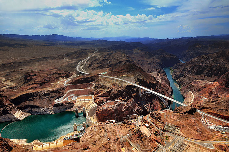
The Colorado River is a vital source of power to many people in the Southwest. The Colorado River means many things to many people: a critical water source, a natural wonder, a region full of cultural significance, and a great place for recreation. It’s also an incredible scientific learning opportunity – a 1,400-mile open air experiment requiring scientists to investigate how to balance the competing water needs for forty million people. This includes everything from microscopic biological processes to big questions like how to ensure future water supplies to meet societal needs in face of a changing climate. Since the 1800s, the Colorado River has been a source of speculation and investigation as early explorers clambered to run its rapids and chart its course. In the early 20th century, the next phase of experimentation began when engineers, geologists, and a host of workers built dam after dam along the river. These projects met the need to make the river's flow more manageable and predictable, but the scale and number of dams, as well as the completely new alteration of the system, made it impossible to anticipate all the impacts related to the river’s management. Plus, changing needs from a growing population made things even more complicated. Only time and research would tell how these changes would affect the river, its ecosystems, and the people living along it. 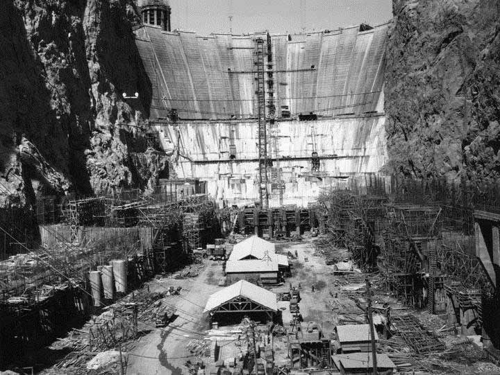
Construction of the Hoover Dam Today, that sense of investigation has intensified as stakeholders and managers have realized that the construction and operation of dams resulted in numerous physical and ecological changes to the Colorado River system. In response to the need for greater understanding of river management impacts and options to mitigate those impacts, researchers are constantly at work running experiments and monitoring studies to inform management interests. Those interests include changes in the amounts and distribution of sediments in the river downstream of dams. With the construction of Glen Canyon Dam, seasonal flooding that once moved sand from the riverbed to the shoreline in the Grand Canyon no longer occurs. Because more than 90 percent of the sediment that historically moved through the Grand Canyon is trapped behind Glen Canyon dam, there is limited sand available in the Canyon to resupply beaches as they erode. The primary sources of new sand to the river system are two downstream tributaries: the Paria and Little Colorado rivers. Studies in the mid-1990s hypothesized that controlled high-volume releases of water, or high flow experimental floods (HFEs), could be important for restoring ecological integrity. Because controlled experimental high-flow releases to some extent mimic natural flooding, by conducting such releases it was felt that it would provide the opportunity to evaluate the potential benefit to sediment-dependent resources including sandbars and camping beaches, marsh and riverside vegetation, and backwaters, which are near-shore areas of low-velocity flow which may be used as rearing habitat by native fish. Testing that hypothesis1 would help determine whether experimental high flows could be used to benefit important physical and biological resources in Grand Canyon National Park and Glen Canyon National Recreation Area. HFEs to date indicate that it may be possible to enlarge and maintain sandbars in Grand Canyon by timing HFEs to occur when sand deposits have accumulated from flooding of the tributary Paria River, and with attention to HFE intensity and duration. 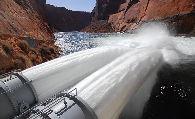
Jet tubes at Glen Canyon Dam release Colorado River water during a high-flow experiment. HFEs seek to move sand from the riverbed to Grand Canyon sandbars, used as camping beaches and to benefit other resources. Photo courtesy of USGS The high flow experiment conducted in 2016 was the seventh such research flow since 1996. Monitoring activities related to the high flow experiment in the Grand Canyon are monitored by the Grand Canyon Monitoring and Research Center. Southern Nevada Water Authority, Lake Mead NRA, and local partner agencies collaborate on water quality monitoring in upper Lake Mead during the event to assess impacts to Lake Mead. Related to HFEs is the Glen Canyon Long Term Experimental Plan completed in 2016. The plan provides a comprehensive framework for adaptively managing water releases through Glen Canyon Dam over the next 20 years to meet the provisions of the Grand Canyon Protection Act and to minimize—consistent with law—adverse impacts on the downstream natural, recreational, and cultural resources in the two park units, including resources of importance to American Indian Tribes. Experimentation called for within the plan includes testing the effects of the following actions: (1) sediment-triggered spring and fall HFEs, up to 45,000 cfs and 96 hr in duration, through the entire 20-year LTEMP period; (2) 24-hr proactive spring HFEs, up to 45,000 cfs, in high-volume years (≥10 maf release volume); (3) extension of the duration of up to 45,000-cfs fall HFEs to as many as 250 hr depending on sediment availability; (4) mechanical removal of nonnative fish near the Little Colorado River confluence; (5) trout management flows; (6) low summer flows in the second 10 years of the LTEMP period to allow greater warming; (7) macroinvertebrate production flows; and (8) experimental vegetation treatments. Another large-scale study is the Colorado River Basin Water Supply and Demand Study (Basin Study), jointly funded and prepared by the Bureau of Reclamation and the seven Colorado River Basin states. The Basin Study examines the imbalance between the supply and demand of the Colorado River’s water, with the goal of ensuring that there’s enough water to go around for the next fifty years. This long-term study uses a huge range of different methods, including temperature data to assess drought conditions, tree ring analysis to estimate how the river’s flow has changed over time, and climate modeling to predict how much water will be available in the future. 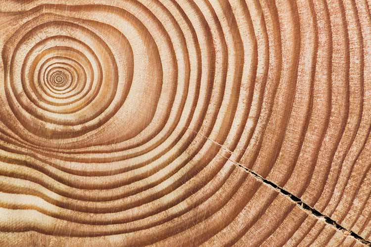
Tree ring analysis estimates how the river's flow has changed over time. The basin study projects that the average imbalance in future supply and demand is projected to be greater than 3.2 million acre-feet by 2060 (one acre-foot of water is approximately the amount of water to supply household needs for five people for one year). The Basin Study report also includes a wide array of adaptation and mitigation strategies proposed by stakeholders and the public to address the projected imbalances. 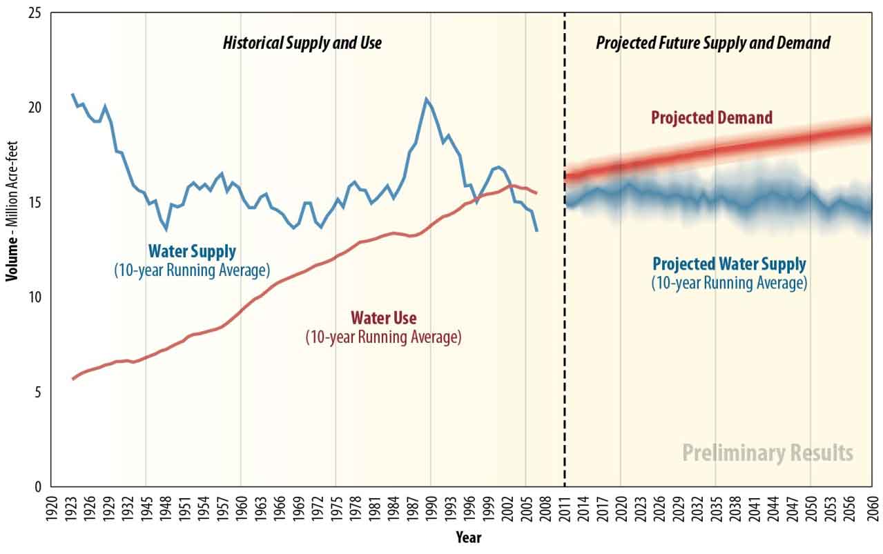
Graph from U.S. Bureau of Reclamation Colorado River Basin and Demand Study showing trends in water supply and demand. These projects not only expand our scientific knowledge of the processes that happen in the lakes, but they also help us understand how the reservoirs can continue to sustain a growing population in a safe and healthy way. The river is essential to the people living in the Southwest and it must be well-understood to serve the needs of everyone - and everything - that depend on it. We often think of scientists in white coats slaving away in laboratories, but to the researchers working on lakes Mead and Mohave, as well as the larger Colorado River ecosystem, these bodies of water are laboratories. They provide opportunities for us we can better understand ourselves, the environment, and how we can improve our relationship with the world around us, even as it continues to change. |
Last updated: April 5, 2017
