
NPS Photo To download the directions, click here (Word doc, 31kb). Popular DestinationsDriving From the Visitor Center head north on Central Ave toward the Arlington Hotel. Pass the hotel, turn left on Whittington Ave (by the second water fountain). As soon as you turn left onto Whittington, you are going to turn right onto Cedar St. Follow Cedar St pass the school into the residential area. Turn right onto Cedarglades Rd. Follow the road up to the top on the mountain, parking for the Sunset Trail is on the right. Across the street from the parking area is the Sunset Trailhead which will take you to Balanced Rock. Hiking Hike up the Sunset Trail to the intersection, go to the left to stay on the Sunset Trail or go right to Balanced Rock. Note: The trail to Balanced Rock does not loop. Driving From the Visitor Center head north on Central Ave toward the Arlington Hotel. Pass the hotel, turn left on Whittington Ave (by the second water fountain). As soon as you turn left onto Whittington, you are going to turn right onto Cedar St. Follow Cedar St pass the school into the residential area. Turn right onto Cedarglades Rd. Follow the road up to the top on the mountain, parking for the Sunset Trail is on the right. Hiking In the parking area you will see the Sunset Trailhead. This trail will take you to Fordyce Peaks. Hike down the Sunset Trail to the intersection, go to the right to stay on the Sunset Trail or go left to see Fordyce Peak. Note: The trail to Fordyce Peak does not loop. Driving From the Visitor Center there are two ways to get to the campground.
By Red Roof Inn = Follow the service road to the stop sign, turn left on Gorge Rd and the campground is on the left. Walking From the Visitor Center head north on Central Ave toward the Arlington Hotel. You will come to and open field, across the street from the Arlington Hotel, these is known as the Arlington Lawn. Just left of the pavilion you will see the Hot Water Cascade. You can go to the top of the cascade by walking up the Tufa Terrace trail to the Grand Promenade. Driving From the Visitor Center head north on Central Ave toward the Arlington Hotel. At the stoplight turn right on Fountain St. Pass the Grand Promenade Trailhead. Turn right onto Hot Springs Mountain Dr. Follow the road up the mountain, you will see the Pavilion on the right, turn left to go to the Mountain Tower. Driving
From the Visitor Center head north on Central Ave toward the Arlington Hotel. At the stoplight turn right on Fountain St. Pass the Grand Promenade Trailhead. Turn right onto Hot Springs Mountain Dr. Follow the road up the mountain. Pass the picnic area and the Pavilion. Continue to drive down Hot Springs Mountain Dr. Stay straight towards North Mountain Loop. You will pass a shelter on the right. Parking will be at the top on the right. Driving From the Visitor Center head north on Central Ave toward the Arlington Hotel. At the stoplight turn right on Fountain St. Pass the Grand Promenade Trailhead. Turn right onto Hot Springs Mountain Dr. Follow the road up the mountain. When at the top, you will see parking for the picnic area and the Pavilion. Driving From the Visitor Center head north on Central Ave toward the Arlington Hotel. Stay on Central Ave following the curve to the right onto Park Ave. Stay on Park Ave for 1.3 miles. When you will see a Shell Gas Station on you right, turn left onto Pullman Ave. Stay left at the fork to stay on Pullman Ave. The Bike park is at the end of Pullman Ave. Driving From the Visitor Center head north on Central Ave toward the Arlington Hotel. Stay on Central Ave following the curve to the right onto Park Ave. Stay on Park Ave for 2.1 miles. You will see a Micky’s BBQ on the right-hand side. As soon as you pass Micky’s, turn left onto Stonebridge Rd. You will see Rick’s Pond on the left and a parking area. Driving From the Visitor Center there are two ways to get to the West Mountain Summit Sunset Trailhead.
Driving From the Visitor Center head north on Central Ave toward the Arlington Hotel. Pass the hotel, turn left on Whittington Ave (by the second water fountain). The road will be divided into a one-way street, stay to the right on Whittington. Go around Whittington Park to the stop sign. Turn left. Park alongside the road by the Whittington Cold Water Jug Station. Whittington Park is across the street. 
NPS Photo Hot Springs and North Mountain TrailheadsHiking Access the Arlington Trail from the Lower Dogwood Trail.
Hiking From the Arlington trail at the “Y” stay to the right and you will see the Floral Trail head.
Hiking As you are walking or driving up fountain street from the Arlington Hotel the trail head will be on your right. Access from the Honeysuckle will be either on the right or left depending on the direction you are hiking the trail.
Hiking You could drive to the North Mountain Overlook or the Gulpha Gorge Campground to get to the Goat Rock Trailhead.
Driving From the Visitor Center, continue south on Central Ave toward Reserve St (It will be the next stoplight down from the Visitor Center). Turn left onto Reserve St. Continue up Reserve St and turn left onto Spring St. At the stoplight, turn left onto E Grand Ave. Cross E Grand Ave by the Red Roof Inn. Right of the hotel there is a dirt road, turn left. *Park in the field by the trailhead.
Walking From the Visitor Center walk between the Fordyce and the Maurice, you will see the grand staircase behind them. Go up the stair or take the ramp to the right. Both will take you to the Grand Promenade. You can also access the Grand Promenade from Reserve St and Fountain St. From the Visitor Center head south on Central Ave toward the City of Hot Springs Visitor Center. At the end of the block take a left on Reserve St. Continue walking up the sidewalk towards the Army & Navy Hospital. You will see the staircase on the left that will take you up to the Grand Promenade. From the Visitor Center head north on Central Ave toward the Arlington Hotel. At the stop light turn right on Fountain St. Continue walking up the sidewalk you will see a red brick road to you right, that is the Grand Promenade Trailhead. By the Hot Water Cascade right behind the pavilion there is a staircase that will take you to two different overlooks of the cascade and to the Grand Promenade.
Hiking There are two trailheads, one on top of Hot Springs Mountain and one at the bottom at the campground.
Hiking The Honeysuckle Trail connects the Peak Trail to the Hot Springs Mountain Trail. You can also walk up the Floral Tail or the Fountain Trail to connect to the Honeysuckle Trail.
Driving From the Visitor Center head north on Central Ave toward the Arlington Hotel. At the stoplight turn right on Fountain St. Pass the Grand Promenade Trailhead. Turn right onto Hot Springs Mountain Dr. Follow the road up the mountain. When at the top, you will see parking for the picnic area and the Pavilion. You can access the trail in the picnic area, by the pavilion, or from the Peak Trail.
Hiking Take the Arlington Trail until it comes to a “Y” and it will turn into the Dogwood Lower Loop trail.
Hiking
Hiking
Hiking From the Visitor Center head south on Central Ave toward the City of Hot Springs Visitor Center. At the end of the block take a left on Reserve St. Continue walking up the sidewalk pass the Army & Navy Hospital. You will pass the Hot Springs National Park Ranger Station, the Libby Bathhouse, and when you will see the apartment complex, the trail is to your left.
Hiking You can hike up the Oertel Trail to connect with Short Cut Trail from the campground or from the Visitor Center. The Short Cut Trail connects the Oertel Trail and the picnic area on top of Hot Springs Mountain, so you could park at the picnic area and take the Short Cut Trail to the Oertel.
Walking
Hiking

NPS Photo Sunset TrailheadsNorth MountainHiking Park by the amphitheater in the campground, walk towards Gulpha Creek which is right of the amphitheater. Cross the creek using the stone walkway. Be careful the stone can be slippery. As soon as you cross the creek, the Sunset Trailhead will be on the right.
Hiking Diagonally across the street from the parking area by Rick’s pond, continue walking up the road a short distant and you will see the Stonebridge Sunset Trailhead. Sugarloaf MountainDriving From the Visitor Center head north on Central Ave toward the Arlington Hotel. Pass the hotel, turn left on Whittington Ave (by the second water fountain). The road will be divided into a one-way street, stay to the right on Whittington. Go around Whittington Park to the stop sign. Turn right onto Black Snake Rd. Follow the road to the top of the mountain, parking will be on the left. Across the street from the parking area is the Sunset Trailhead going toward Cedarglades Road and Balanced Rock. The Sunset Trailhead in the parking area goes towards West Mountain Summit.
Driving From the Visitor Center head north on Central Ave toward the Arlington Hotel. Pass the hotel, turn left on Whittington Ave (by the second water fountain). As soon as you turn left onto Whittington, you are going to turn right onto Cedar St. Follow Cedar St pass the school into the residential area. Turn right onto Cedarglades Rd. Follow the road up to the top on the mountain, parking for the Sunset Trail is on the right. Across the street from the parking area is the Sunset Trailhead going toward Black Snake Road and Balanced Rock. The Sunset Trailhead in the parking area goes towards Fordyce Peaks and Stonebridge. West MountainDriving From the Visitor Center there are two ways to get to the West Mountain Summit Sunset Trailhead.

NPS Photo West Mountain TrailheadsThere are 3 access points Hiking When leaving the Fordyce Visitors Center turn right and continue along Bathhouse Row toward the Arlington Hotel. At the stoplight cross Central Avenue toward the Wax Museum. Turn right at the museum continue along Central Avenue past the Pancake Shop Restaurant, when you see Mountain Valley Spring Water sign turn left. Follow Canyon Street up the hill and the road will turn into the trail head. Driving #1 (Driving Via Whittington Park) From the Visitors Center travel North on Central Avenue (Highway 7), pass the Arlington Hotel on you right. Stay on Central Avenue just past Fat Jack’s Restaurant is a left turn onto Whittington Ave. Continue on Whittington Avenue following the road until you see the Weyerhaeuser Building. Turn left at the Weyerhaeuser Building. Stop at the stop at the stop sign Turn left at the stop sign onto Whittington Avenue passing the Hot Springs National Park Maintenance Shop on the right. Continue on Whittington until you see a turn for West Mountain Drive. Turn Right on West Mountain Drive until you see a fork at the fork turn up the hill. Continue up the hill until you see a shelter with a parking lot pull into lot. Trail is across the street. Driving #2 (Via Prospect Avenue) From the Visitors Center Head South Central Avenue (Highway 7). Look for Reserve Street (Diablos Restaurant is on your right) Turn right one block the stop sign is Exchange street. Turn left on Exchange Street at the stop sign will be Prospect Avenue. Turn Right on Prospect go past Levi Hospital on the right stay on Prospect avenue until you see the National Park Sign for West Mountain. Turn right and follow road until fork. Stay to the left go up the hill until you see a shelter with a parking lot pull into lot. Trail is across the street. There are 2 access points: From the Visitors Center, travel North on Central Avenue (Highway 7), pass the Arlington Hotel on your right. Stay on Central Avenue just past Fat Jack’s Restaurant is a left turn onto Whittington Ave. Continue on Whittington Avenue following the road until you see the Weyerhaeuser Building. Turn left at the Weyerhaeuser Building. Stop at the stop at the stop sign Turn left at the stop sign onto Whittington Avenue passing the Hot Springs National Park Maintenance Shop on the right. There will be a turnout just before West Mountain Drive. Park at the turnout and trailhead is to the right. Driving #2 – Prospect Avenue From the Visitor's Center, head South on Central Avenue (Highway 7). Look for Reserve Street (Diablos Restaurant is on your right) Turn right one block the stop sign is Exchange street. Turn left on Exchange Street at the stop sign will be Prospect Avenue. Turn Right on Prospect go past Levi Hospital on the right stay on Prospect avenue until you see the National Park Sign for West Mountain. There are 2 access points: Hiking Up Canyon trail about quarter mile canyon trail will come to a fork. Oak trail is on the left. Driving via prospect Avenue From the Visitors Center Head South Central Avenue (Highway 7) Look for Reserve Street (Diablos Restaurant is on your right) Turn right one block the stop sign is Exchange street. Turn left on Exchange Street at the stop sign will be Prospect Avenue Turn right on Prospect go past Levi Hospital on the right stay on Prospect avenue until you see the National Park Sign for West Mountain. Turn right on to West Mountain Drive. Follow road until you see a crosswalk. Oak trail crosses West Mountain Drive at this point. There are 4 access points : Hiking #1 Follow the Canyon Trail crossing at the crosswalk. Go up the trail until you see a sign for the West Mountain Trail. Hiking #2 Canyon Trail Continue on Canyon Trail crossing at the crosswalk shelter will be on your left and just off the parking lot to the right will be a sign for the West Mountain Trail. Driving #1 via Whittington Park From the Visitors Center travel North on Central Avenue (Highway 7), pass the Arlington Hotel on you right. Stay on Central Avenue just past Fat Jack’s Restaurant is a left turn onto Whittington Ave. Continue on Whittington Avenue following the road until you see the Weyerhaeuser Building. Turn left at the Weyerhaeuser Building. Stop at the stop at the stop sign Turn left at the stop sign onto Whittington Avenue passing the Hot Springs National Park Maintenance Shop on the right. Continue on Whittington until you see a turn for West Mountain Drive. Turn Right on West Mountain Drive until you see a fork at the fork turn up the hill. Continue up the hill until you see a shelter with a parking lot pull into lot. Trail is across the street or to the right of the parking lot. Driving #2 via Prospect Avenue From the Visitors Center Head South Central Avenue (Highway 7). Look for Reserve Street (Diablos Restaurant is on your right) Turn right one block the stop sign is Exchange street. Turn left on Exchange Street at the stop sign will be Prospect Avenue. Turn Right on Prospect go past Levi Hospital on the right stay on Prospect avenue until you see the National Park Sign for West Mountain. Turn right and follow road until fork. Stay to the left go up the hill until you see a shelter with a parking lot pull into lot. Trail is across the street. 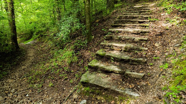
Hiking
With 26 miles of hiking trails in the Park, you can find great views, beautiful forest scenery, and feel like you're not in the City. 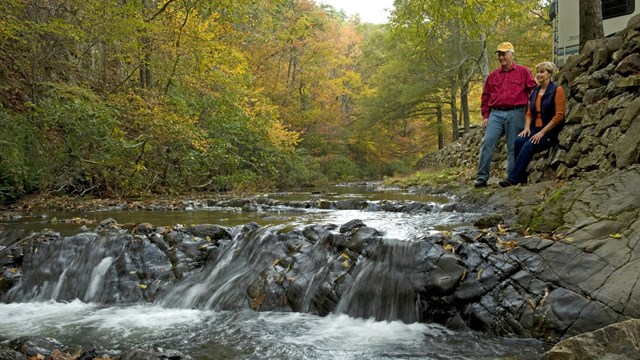
Gulpha Gorge Campground
With 40 sites right by Gulpha Creek, the Gulpha Gorge Campground is the perfect place to relax and enjoy the beauty of the Park. 
Soak in the Springs
Fully submerge yourself in the thermal water and let your worries melt away. 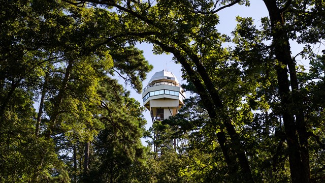
Hot Springs Mountain Tower
View Hot Springs from atop the Mountain Tower. Learn more about the history of this Hot Springs icon. 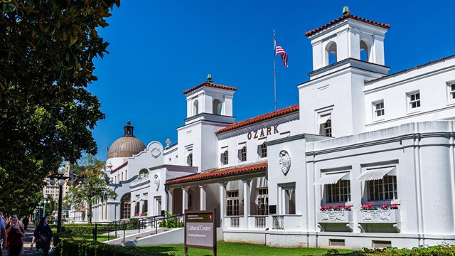
Bathhouse Row
Bathhouse Row is home to the Park's historic bathhouses. Learn about what is available in each of the bathhouses today. |
Last updated: October 2, 2020