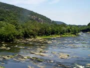
NPS photo While visiting the park's historical district, walk past John Brown's Fort, under the Winchester and Potomac Railroad bridge, and out to The Point. From here one can observe the two rivers that border either side of the town. On the left lies the Potomac River and to the right lies the Shenandoah River. About 360 million years ago, the Potomac began cutting its way through the Appalachian Mountains, forming the water gap that lies between Maryland and Loudoun Heights. After the Appalachians were worn down, run-off water collected at their base, forming the Shenandoah River. When visiting Harpers Ferry today, one can see how the Shenandoah and Potomac gracefully come together, flowing eastward to the Chesapeake Bay as the Potomac River. |
Last updated: April 1, 2022
