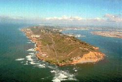
NPS Photo The drive to Cabrillo National Monument will take you through diverse areas that tell of the Point Loma peninsula’s history. In Spanish, “loma” means “hill,” and is a fitting description of the rolling topography of the area. Archaeological remnants tell of human occupation of the Point as far back as 7,000 years. In 1797, the Spanish constructed Fort Guijarros on the eastern side of the peninsula, as a means of guarding the entrance to the harbor. Fifty-five years later, in 1852, the southern portion of Point Loma was set aside as a military reservation. Fort Rosecrans National Cemetery was established in 1934 and today honors over 120,000 veterans and dependents who are interred there. Residential neighborhoods on Point Loma were originally established by generations of fishermen and remain varied today, with small cottages tucked next to multi-million dollar homes. Catalina Boulevard is part of San Diego’s 59-mile Scenic Drive, and affords spectacular panoramic views of the ocean and city on your way to Cabrillo National Monument. 
NPS Photo Driving to Cabrillo National Monument takes you through a Navy gate. If it is staffed by Navy personnel, slow down at the white gate and follow their instructions. When it is unstaffed, proceed slowly through the gate. For the next 2.5 miles of the drive, you will see more Navy structures and beautiful views of Fort Rosecrans National Cemetery, Downtown San Diego, and the Pacific Ocean. 
NPS Photo On Holidays and weekends, the wait time to enter the park can be 30 minutes or longer. We recommend arriving before 11 am on Holidays, weekends, and low tide days to avoid the wait. In this photo looking north, the line of cars to enter the park is backed upthrough Fort Rosecrans National Cemetery. Cyclists can use the bike lane and pedestrians can use the walk-up window. Of the park entrance station. 
NPS Photo Rangers and park volunteers will greet you at the park entrance. FROM DOWNTOWN SAN DIEGO
FROM INTERSTATE 5 NORTHBOUND
FROM INTERSTATE 5 SOUTHBOUND
FROM INTERSTATE 8 WESTBOUND
|
Last updated: November 28, 2023