|
You are viewing ARCHIVED content published online before January 20, 2025.
Please note that this content is NOT UPDATED, and links may not work. For current information,
visit https://www.nps.gov/aboutus/news/index.htm.
NPS
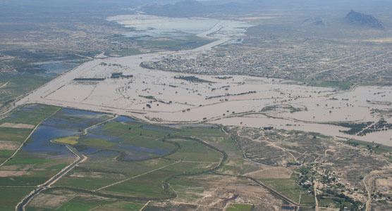
Last Update January 31, 2009. Some damage still remains. - Woodsens and Jewel Camp 2 still closed. - The boardwalk nature trail at Rio Grande Village was washed away. - The launch sites for float trips upstream and downstream of Mariscal canyon have been destroyed. Highway 170 from Lajitas to Presidio has reopened but includes a 1.7 mile dirt detour graded for all vehicles. For those pulling long 5th wheel trailers and RVs, be advised that there is one 40 yard long gravel hill with a 15% grade. Rio Grande Village: Only 10 sites remain closed at this time. 90 are open. The boat launch/river access point has been cleared of debris. The RV campground, store and gas station are also open at the Village. Castolon: The Cottonwood campground is open. The paved road from Castolon to Old Maverick Road has reopened so that visitors can take the loop drive. River Road River Road should not be attempted without high clearance and 4 wheel drive due to deep wash crossings and sand. Some campsites off the River Road that were next to the river have been destroyed. For example, the Solis, La Clocha, and Talley sites on the river were washed away, but the other Solis, La Clocha, and Talley sites survived the flooding. Woodsons and Jewel 2 are closed. Mariscal Canyon float trips Put in and take out spots along the Rio Grande in the vicinity of Mariscal Canyon were destroyed by the floods. These conditions will change as NPS personnel can repair damage to infrastructure, which is a top priority. Check back daily or call the park for updated information. (432) 477-1158 Overview of Tropical Depression Lowell In mid-September, 2008, Tropical Depression Videos showing the height of the flood are available on YouTube, but they were not made by the National Park Service, and the NPS is not responsible for their content. Normally 2-3 feet deep, the The park is issuing permits for river use and local outfitters are offering a variety of float trips. Check with the park or local outfitters to get up-to-date information on current conditions. 
NPS - T Alex 
NPS - J. Sartain 
J. Axel - NPS |
Last updated: February 24, 2015