Vegetation mapping is a tool used by botanists, ecologists, and land managers to better understand the abundance, diversity, and distribution of different vegetation types across a landscape.
Importance and Background
Vegetation mapping is a tool used by botanists, ecologists, and land managers to better understand the abundance, diversity, and distribution of different vegetation types across a landscape. The U.S. Geological Survey (USGS) and the National Park Service (NPS) formed the USGS-NPS Vegetation Characterization Program in 1994 to cooperatively inventory and map vegetation in more than 280 national park units across the United States. The program’s goals are to provide baseline ecological data for park resource managers, obtain data that can be examined in a regional and national context, and provide opportunities for future inventory, monitoring, and research activities.

Muldavin et al. 2013
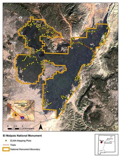
In 2002, as part of the larger USGS-NPS Vegetation Mapping Program, the Southern Colorado Plateau Network (SCPN) began a study of the distribution of vegetation types across network parks. The SCPN vegetation mapping initiative started with the acquisition of aerial imagery in 2002. By 2003, field studies at four parks in the network were underway, with eight additional vegetation mapping projects initiated between 2004 and 2006. The last of these projects --the vegetation mapping project at El Malpais--was completed in 2013.
Vegetation maps for the three Flagstaff monuments were completed through an earlier effort. Grand Canyon NP recently completed its vegetation map, and the staff of Glen Canyon NRA is currently working with the NPS Vegetation Mapping Program to complete its vegetation map.
Vegetation Mapping
Vegetation sampling field work was designed to capture as wide a variety of vegetation types as possible within the seasonal time frame available for field work. The classification system used in SCPN vegetation mapping projects was based on the National Vegetation Classification Standard (NVCS) adopted by the Federal Geographic Data Committee in 1997 and updated in 2008.

Muldavin et al. 2013
The products generated by vegetation mapping projects meet Federal Geographic Data Committee Standards for vegetation classification and metadata, and national standards for spatial accuracy and data transfer. Core products for a completed vegetation mapping project include a report, spatial vegetation and boundary data, and related metadata. Additional products may include
- aerial photography
- vegetation classification
- map classification description and key
- dichotomous field key of vegetation classes
- formal description for each vegetation class
- field data in database format
- field plots spatial data
- vegetation spatial data
- geodatabase for all spatial data
- boundary spatial data
- accuracy assessment spatial data
- metadata for spatial databases
- ground photos of vegetation classes
- graphics for vegetation maps, for field plots, accuracy assessment point, aerial photography

Muldavin et al. 2013
Management Applications
Vegetation mapping projects describe, classify, and map the plant communities in national parks. These descriptions of plant communities and the maps of their spatial distribution serve as tools for making resource management decisions and for increasing the scientific understanding of plant species and communities in the broader region.
For More Information
Prepared by Jean Palumbo, Southern Colorado Plateau Network Inventory and Monitoring Program, 2014.
Tags
- aztec ruins national monument
- bandelier national monument
- canyon de chelly national monument
- chaco culture national historical park
- el malpais national monument
- el morro national monument
- hubbell trading post national historic site
- mesa verde national park
- navajo national monument
- petrified forest national park
- petroglyph national monument
- salinas pueblo missions national monument
- sunset crater volcano national monument
- walnut canyon national monument
- wupatki national monument
- swscience
- american southwest
- southern colorado plateau
- plants
- scpn
- vegetation mapping
- project
- inventory
- jmrlc
- natural resources
Last updated: January 12, 2023
