Part of a series of articles titled Chilkoot Tramways.
Article
The Chilkoot Railroad and Transportation Company Tramway

NPS image
The Chilkoot Railroad and Transport Company was the longest, most sophisticated and best known of the three aerial tramways built over pass. Several accounts describing the history of the line have been published.60
The line was conceived in the summer of 1897. Major officials involved in the venture included Archie McLean Hawks, chief engineer; Hugh C. Wallace, president and construction superintendent; investor Britton Gray; and vice-president G. B. Pierce.61 At first, the line's directors proposed building a road from Dyea to Sheep Camp and a tram line from Sheep Camp to Crater Lake. Later, it was proposed that the route from Dyea to the site of Canyon City be upgraded to a horse-drawn tram road, and several brochures announced that the company was constructing a railroad up the Taiya River valley.62 An extension of the tramway from Crater Lake to Lake Lindeman was also considered. Initial reports announced that the line would be completed as early as January 1, 1898.63
Financial considerations, however, forced the company to implement a more modest tramway system than was first envisioned. The line, as built, began in Canyon City and stretched nine miles north to Stone Crib, near Crater Lake. The mountainous terrain and heavy snowfall also derailed the directors' plans, and delayed construction schedules repeatedly. Although materials began to arrive in October, construction crews were not able to begin work until December 10, and the line was not completed until May.64 The opening of the line was a two-stage process. The section between Canyon City and Sheep Camp was finished by the first week in May.65 The Dyea Trail announced, perhaps over-optimistically, that the entire tramway system was completed by May 7. One witness, however, noted that the tram did not begin for a week afterwards, and another noted that the tram started operating on May 24, 1898.66

Photo courtesy of University of Washington's Eric A. Hegg Collection
When completed, the Chilkoot Railroad and Transport Company advertised an efficient, integrated transportation network stretching from Dyea to Lake Lindeman. Goods off-loaded at Dyea were placed on the CR&T-controlled Long Wharf, and hauled up to the company's large, two-story warehouse located at the foot of Main Street. Goods continued north to Canyon City over a wagon road that had been claimed by the company as a railroad right-of-way. The CR&T tramway began at the powerhouse at the north end of Canyon City. Tramway lines followed the east side of the canyon to Pleasant Camp, then crossed the river and proceeded up the west bank to Sheep Camp. The CR&T operated a second powerhouse at the south end of Sheep Camp, five miles north of Canyon City. Here the first cable loop ended and the second one began.
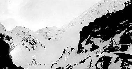
The tramway largely paralleled the Chilkoot Trail north of Sheep Camp, and crossed it in several places. The line swung high over the Scales; it then continued past the summit to its terminus, one-half mile north of the border.67 The CR&T contracted with pack train operators and with Native packers to haul goods the remaining ten miles from Stone Crib to Lake Lindeman.
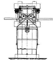
The various tension stations along the nine mile tramway were only a small part of the diverse CR&T network, but they are among the few artifacts of the system that can still be seen in the field today. Like the tramway towers, the tension stations were built in the late winter or early spring of 1898, and probably lay idle for over a month before tramway operations began.68 Their purpose was to keep a strong, even tension on the tramway wires. Short tramway lines did not need tension stations; they were able to maintain tension at their terminal points. Due to saddle friction, however, lines such as the CR&T required that tension stations be built every 3000 to 6000 feet along the route.69
As a contemporary guide to tramway systems explained:
The points usually selected [for the tension stations were either] on the side of a hill, or on some level portion of the ground. The track cables are parted at these points, the ends of the upper section of the line being counter weighted, and the ends of the lower sections being firmly anchored. The cars pass from one section of the cable to the next by means of intervening rails, so that no interruption occurs in the continuity of the track. Occasionally such a station will happen in a valley or ravine, in which both sections of the line are counter weighted, or it may be desirable to locate such a station on an elevated point, in which case both ends are anchored.70
The only two known sites of Chilkoot tension stations were located on the sides of hills.
The CR&T tramway operated intermittently for approximately fourteen months. Shortly after it opened, the White Pass and Yukon Route began constructing its railroad over adjacent White Pass. Passenger traffic over the Chilkoot Trail, therefore, dwindled to a trickle. Freight rates over the tramway line, however, were competitive with those offered by the railroad. As a consequence, tramway business was good. Severe weather during the winter of 1898-99, however, made it necessary for engineers to strengthen key parts of the system. New tension stations, or stronger box-like adaptations of existing stations, may have been built at that time.71
In late June 1899, an observer found the tramway line in operation, and laden with Yukon-bound freight. But just a week later the railroad tracks were opened to Lake Bennett, and the tramway was doomed. The rival WP&YR company purchased the tramway, and all operations stopped. In January 1900, salvage operations began. Beginning at Stone Crib and working south, crews dismantled and removed engines, wire, buckets and other reusable machinery. The removal crews were thorough; by the end of April, all that remained were the tramway towers, tension stations, power stations and other wooden improvements.72 The remains of those items are still seen today by Chilkoot Trail hikers.
A few yards north of the collapsed AR&T powerhouse are the remains of one of the CR&T's tension station. It is a diagonally braced platform of 6 x 6 foot timbers anchored to rock with one inch rods. It is 28 feet long and 8½ feet wide and is located at approximately mile 15.6 on the trail. The remains of another tension station are located just east of the trail at mile 14.5. A large metal wheel seen along the trail at this point was once part of this station. The tramway line that cut through the forest from Canyon City to Sheep Camp is clearly seen on aerial photographs taken in 1970. It is quite likely that additional tension stations many associated tramway artifacts await to be located.
Written by Frank Norris, edited by Karl Gurcke.
60. Bearss, Klondike Gold Rush, pp. 123-28, 273-74; Spude, Chilkoot Trail, pp. 201-203; Hewitt, "Across the Chilkoot Pass," pp. 529-538.
61. Spude, Chilkoot Trail, p. 201; Bearss, Klondike Gold Rush, pp. 123-24; Lung/Martinsen, Black Sand and Gold, pp. 37, 375 photo.
62. Bearss, Klondike Gold Rush, p. 124; Spude, Chilkoot Trail, p. 84. Crude wooden tracks for the horse tram were constructed through much of Dyea along Broadway Street, but they were not completed to Canyon City and they were never known to be used. KLGO collection, photos DB1, DB6 and DC1.
63. Hewitt, "Across the Chilkoot Pass," p. 529; Spude, Chilkoot Trail, p. 203; Sitka Alaskan, 12/4/97.
64. Sitka Alaskan, 10/23/97; Bearss, Klondike Gold Rush, p. 124.
65. Hewitt, "Across the Chilkoot Pass," pp. 529-30; McMillan, "Diary," 5/7/98.
66. Dyea Trail, 5/7/98, p. 4; Berkeley letter, p. 6; Lung/ Martinsen, Black Sand and Gold, p. 385.
67. The span between towers in the Scales area, totaling over a quarter of a mile, was the greatest distance for any world tramway up to that time. It should also be noted that one of the only known stampeders to ride over the tramway route wrote that he got off at the summit, not at Stone Crib. Inasmuch as freight needed to be inspected by the border officials, it was probably off-loaded at the summit also. Spude, Chilkoot Trail, p. 201; Lung/ Martinsen, Black Sand and Gold, p. 392; Cotton, "Memoirs," p. 3.
68. KLGO collection, photos LH4 and LH6; Spude, Chilkoot Trail, p. 98.
69. Hewitt, "Across the Chilkoot Pass," p. 535.
70. Hewitt, "Across the Chilkoot Pass," pp. 535-36.
71. Skagway Alaskan, 2/3/99; Spude, Chilkoot Trail, p. 203.
72. Bearss, Klondike Gold Rush, pp. 273-74.
Last updated: May 1, 2018
