The aridity, warm temperatures, and clear skies of the Southwest result from its position between the mid-latitude and subtropical atmospheric circulation regimes. Precipitation, while sparse, peaks in the summer during the monsoonal storms, and again in the winter from storms originating in the Pacific Ocean.
Introduction
The overall climate of the Southwest—its weather patterns over a long period of time—tends to be warm and dry. But records of past climate show that southwestern climate is also highly variable, both across the landscape and over time. Annual temperatures and precipitation tend to be very different from one year to the next, and the Southwest has also seen major climate shifts that have lasted for centuries; for example the Southwest dried out significantly over the entire period between AD 1000 and 1450 in a series of epic droughts known as the medieval megadroughts.
Now another shift in climate is happening, but this time most climate scientists think that people, not natural processes, are driving the shift. Human activity, such as the burning of fossil fuels, is releasing greenhouse gases like carbon dioxide and methane into the atmosphere. The build-up of these gases over time is leading to a rapid global rise in temperature. Using past and present climate records, scientists have been modeling how increases in greenhouse gases will affect the earth’s climate in the future and how a climate shift might affect ecosystems and human society.
Read on for a sweeping overview of climate change in the Southwest, or visit the Science of the American Southwest Climate Change webpage to learn about specific climate change projects.
Current climate

The climate of the Southwest is most influenced by its geographic location between the mid-latitude and subtropical atmospheric circulation regimes. This positioning leads to year-round warm temperatures, low annual precipitation, and clear skies. However, because of its location near two major moisture sources—the Pacific Ocean and the Gulf of Mexico—the Southwest has two noticeable peaks in precipitation every year. July through September, precipitation comes from monsoonal storms that derive their moisture from both the Pacific Ocean and the Gulf of Mexico, and November through March, the precipitation comes from winter storms originating in the Pacific Ocean (Sheppard et al. 2002). During the months between these peaks, very little precipitation falls.
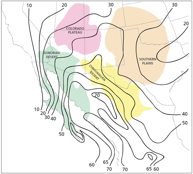
The influence of the monsoon on total annual precipitation depends upon the location. The monsoon tends to be strongest in northwestern Mexico and weakest towards northern Arizona and New Mexico (Adams and Comrie 1997). Areas south of an imaginary line that runs just north of Tucson and east into New Mexico receive more than 50% of their annual precipitation during July, August, and September (Douglas et al. 1993). The mean northern extent of the monsoon forms a diagonal line through far northwestern Arizona up into Utah and Colorado (Mitchell 1976). Between this line and the line just north of Tucson, precipitation peaks in both the winter and the summer. North of this line, precipitation is spread evenly over the year (Comrie and Glenn 1998). The strength of the monsoon varies from year to year, but researchers are currently unsure why (Adams and Comrie 1997).
Winter storms, in contrast to monsoonal storms, cause widespread precipitation over a large geographical area, affecting distinct locations similarly. The amount of winter precipitation that the Southwest receives in a given year strongly depends on the sea surface temperatures in the Pacific Ocean. During El Niño years (periods when the sea surface temperatures of the eastern Pacific Ocean near the equator are warmer than normal), the Southwest experiences wetter winters. The opposite is true of La Niña years (when the sea surface temperatures of the eastern Pacific Ocean near the equator are cooler than normal). Winter precipitation is also influenced by the Pacific Decadal Oscillation (PDO), a climate pattern that can last for several decades when the temperatures in the northeastern Pacific Ocean are warmer or cooler than usual. When the temperatures are warmer, known as the positive phase of the PDO, the Southwest experiences wetter winters. The effects of El Niño tend to be even stronger during the positive phase of the PDO, and the effects of La Niña tend to be even stronger during the negative phase of the PDO (Sheppard et al. 2002).
Regional climates

Because of the extremes in topography in the Southwest and its position between two major atmospheric circulation regimes, the climates of particular locations in the Southwest can be quite distinct from one another. The Sonoran and Chihuahuan Deserts experience milder winters and hotter summers than the Colorado Plateau since the Colorado Plateau is on average several thousand feet higher in elevation than the Sonoran and Chihuahuan Deserts. The Southern Plains, which are at about 7,000 feet in elevation in the northwest and about 1,000 feet in elevation in the southeast, likewise show a gradient in winter temperatures from colder in the northwest to warmer in the southeast. Summer temperatures do not show this gradient and are on average only slightly cooler than the adjacent deserts.
The average precipitation that falls on the deserts, the plateau, and the plains differs as well. The Sonoran Desert receives 3 to 20 inches annually, and the Chihuahuan Desert receives 6 to 20 inches annually, while the Colorado Plateau receives 10 to 35 inches in a year. The ranges for average precipitation are so wide because each region features mountain ranges that are colder and wetter than the surrounding areas. The two deserts receive their precipitation at different times of the year: summer and winter for the Sonoran Desert, but only during the summer for the Chihuahuan Desert. The western edge of the Southern Plains is also dry, but the plains become wetter towards the east. Precipitation in the Southern Plains averages 12 to 39 inches, mostly falling from April through September.
Part of a series of articles titled Climate Change in the Southwest.
Tags
Last updated: August 14, 2017
