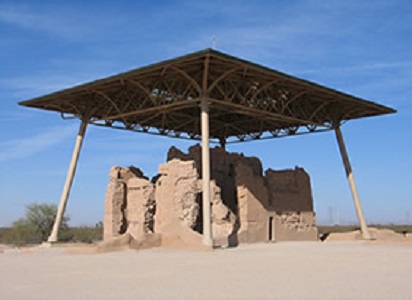
Courtesy of National Park Service
In the arid southern Arizona desert, on a flat plain between the Gila and Santa Cruz rivers, a large building comes into view that makes an immediate impression on any observer. This “Great House,” the Casa Grande Ruins, dates from the 14th century and is the largest known structure that the Hohokam Indians of the Gila Valley built. Casa Grande Ruins National Monument, which became the first archeological preserve in the United States in 1892 and then a National Monument in 1918, protects, preserves, and interprets the Casa Grande (Great House) complex, as well as 60 other pre-contact sites all dating from sometime between 1150 and 1350 AD. These sites contribute to our understanding of American Indian cultural heritage in the United States.
When the first European visited Casa Grande in 1694, the Hohokam Indians and their ancestors who had lived in the Gila Valley since 5,550 B.C.E. were long gone. The Hohokam ancestors include the ancient Sonoran Desert people and people from the Mesoamerican civilization. The ancient Sonoran Desert people formed a hunter and gatherer community that survived for hundreds of years by hunting the desert’s wild animals and gathering the wild plants. Eventually though, the desert’s climate became warmer and warmer, which decreased the amount of wild plants and animals available to sustain this community. The ancient Sonoran Desert people adapted, and with the introduction of Mesoamerican domesticated corn, made the gradual transition from being a hunter and gatherer community to a more sedentary farming community.
By about 300 CE, the ancient Sonoran Desert people evolved into a distinct Hohokam culture. To adapt to the dry conditions of the desert, they began to use river run-offs and dig irrigation canals to provide water for their fields. Archeologists have identified hundreds of miles of irrigation canals in the American Southwest that link directly back to this culture and time period. With the use of irrigation canals, the Hohokam culture flourished and grew to include many communities along the Gila, Salt, Santa Cruz, and Verde rivers, and their tributaries.
Throughout the area, the Hohokam grew corn, beans, squash, tobacco and cotton. They collected wild foods like mesquite pods, prickly pear fruit, and saguaro fruits, and hunted wild game including mule deer, bighorn sheep, snakes, lizards, squirrels, and rabbits. In their scattered communities, they built pithouses and eventually more permanent above ground structures, and also made a distinct “red-on-bluff” pottery. The people traded the pottery and jewelry they made for turquoise, macaws, mirrors, and copper bells. Throughout their communities, they also constructed ball courts, one of which can be viewed from a public observation platform in the park. Eventually, by the Classic Period (1100-1450 BCE), the Hohokam established more formalized villages.
Around 1150, many Hohokam left their outlying settlements to live in more concentrated and formalized river villages like Casa Grande. The villages were walled compounds where aboveground caliche structures dominated the space. Caliche is a natural concrete-like material made of sand, clay, and calcium carbonate found under the topsoil of the region. In these walled compounds, clusters of caliche houses surrounded public plazas and public structures. Around 1350 AD, the construction of the Casa Grande was complete within one of these Hohokam village compounds.
It took nearly 3,000 tons of caliche to build the Casa Grande. The walls are four feet thick at the base, and taper toward the top. Juniper pine and fir tree timbers formed the internal support for the walls, ceilings, and floors, and created a surface for a layer of caliche. The Hohokam obtained the juniper pine and fir trees from forests as far away as 60 miles up the Gila River. They harvested the trees then carried or floated them down the river to their final destination. To ensure the strength of the structure further, they laid saguaro ribs perpendicular across the internal supporting beams, covering them with reeds and then a layer of caliche. Despite centuries of harsh desert weathering and neglect, this massive structure serves as a lasting testament to the Hohokam culture, technology, and society.
Situated at the end of a major canal, the Casa Grande, like other Great Houses, likely played a major role in the organization of the irrigation communities. The structure stands 4 stories high and 60 feet wide and likely was designed for height and celestial observation. Archeologists hypothesize that the structure’s height was necessary to help regional farmers observe areas that needed canal maintenance and water regulation. Also, due to Casa Grande’s positioning to the four cardinal points of the compass and its specific holes and openings that allow for celestial observation, archeologists believe that the structure was used to observe the changing positions of celestial objects in order to organize planting, harvests, and celebrations.
For reasons still unknown, sometime in the 15th century, the Sonoran Desert people abandoned the walled village compounds. Today, the Casa Grande serves as the main area for the public to visit at Casa Grande Ruins National Monument providing visitors with a direct connection to the people who once lived there. A stop at the visitor center, followed by a self-guided walk around the Casa Grande, will provide visitors with a memorable view of Hohokam technology and society.
Casa Grande Ruins National Monument, a unit of the National Park System, is located in Coolidge, AZ, just off AZ 87/287. The National Monument is open from 9:00 am until 5:00 pm everyday of the year except Thanksgiving Day and December 25th. For more information, visit the National Park Service Casa Grande Ruins National Monument website or call 520-723-3172.
Casa Grande Ruins National Monument has been documented by the National Park Service’s Historic American Buildings Survey and is featured in the National Park Service American Southwest Travel Itinerary.
Last updated: August 7, 2017
