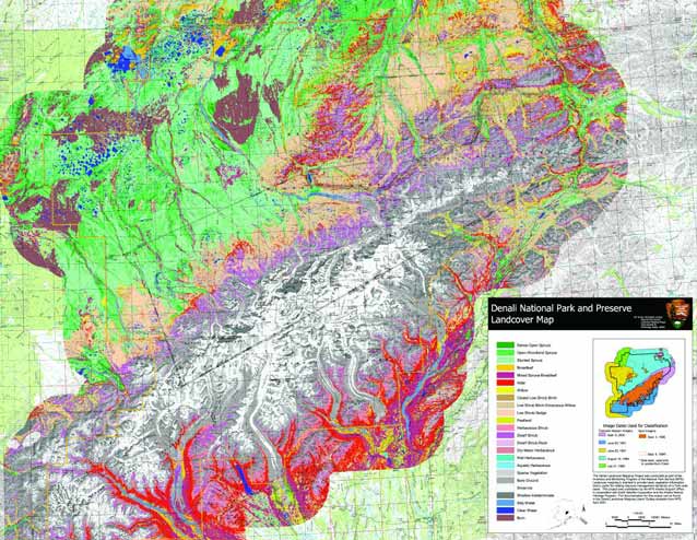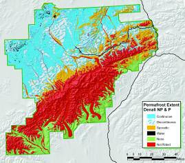
The Inventory and Monitoring Program has recently produced two new tools for natural resource monitoring and management of Denali National Park and Preserve: a comprehensive soil inventory and ecological classification, and a land-cover map based on satellite imagery. The products provide researchers, educators, and managers data that will allow for more informed research design, detection of natural resource change at a park-wide scale, more accurate and comprehensive education material, and baseline information for park management.
The landcover mapping program was completed by the NPS Alaska Support Office in collaboration with the Alaska Natural Heritage Program (University of Alaska Anchorage) and Earth Satellite Corporation (Rockville, MD). The development of the landcover map involved collection and analysis of field-verified datasets, and the analysis and interpretation of remotely sensed imagery (satellite and aerial photography). Landcover was mapped at intermediate scales (1:63,360 to 1:100,000) with 25 classes, following a modified version of the Alaska Vegetation Classification system. The classification system was based primarily on vegetation structure (plant height) and form (tree, shrub or herbaceous), and to a lesser extent genera and species information. Landsat Thematic Mapper multi-spectral imagery was the primary data source, and SPOT XS data was the secondary source. Digital image processing was refined through iterative modeling using environmental and spectral data layers such as slope, elevation, the Normalized Difference Vegetation Index (NDVI), and available field data.
The landcover map allows users to understand the distribution of vegetation across the landscape and determine relative distribution of plant associations across the park.
The most dominant of the 25 landcover classes are:
- snow-ice (16%)
- stunted spruce (14%)
- bare ground (10%)
- low shrub birchericaceous-willow (10%)
- open-woodland spruce (9%)
- shadow / indeterminate (7%)
- dwarf shrub (6%).
Plant associations were described using the ground data and a literature review. Plant associations provide a hierarchical link between the coarse scale landcover classes and finer scale species information.

While the landcover map provides an overall view of the plant cover types and their distribution, the recently completed soil inventory provides detailed mapping and site information, including comprehensive ecological site classifications for over 2,200 sites in Denali. The survey was a cooperative effort of the Natural Resources Conservation Service, the National Park Service, and the University of Alaska Fairbanks. The final product, a result of fieldwork completed from 1997 to 2002, includes a 1:63,360 scale soils map with an attribute database and metadata, a database containing detailed soil and ecological data, digital site photographs, landtype and map unit distribution maps, figures, illustrations, soil temperature graphs, and a complete orthophoto mosaic of Denali. The data provide a comprehensive delineation of park ecosystems, including new discoveries of range extensions and previously undocumented natural processes in the park. The spatial database allows user-defined interpretations, including permafrost extent, extent of potential natural vegetation, landscape processes, and countless other queries.
Part of a series of articles titled Alaska Park Science - Volume 5 Issue 1: Scientific Studies in Denali.
Last updated: March 16, 2015
