NASA
Hard-rock mining for metals is an economically important land use. As world population increases so does demand for metals, including copper (Cu); from 1900 to 2012 world refined copper demand increased from less than 0.6 million tons to more than 22 million tons (ICSG 2013).
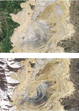
Copper is used to conduct electricity and serves important functions in transportation and construction. Although the U.S. recycles approximately 30 percent of apparent Cu supply (Goonan 2009), mining is necessary to meet demand (Figures 1a and 1b). Most accessible Cu deposits in the Lower 48 and world have been or are being exploited and mineral interest in remote Alaska accelerated during the last decade (Szumigala 2012).
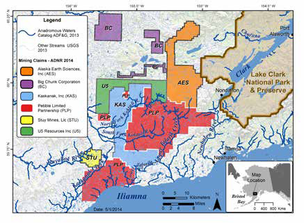
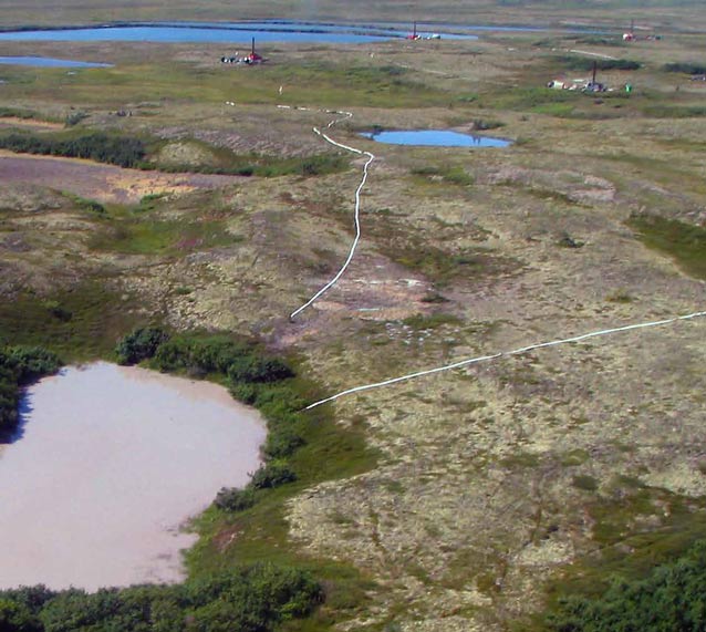
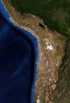
Several porphyry Cu deposits are being explored in Bristol Bay, namely Big Chunk and Pebble (Figures 2 and 3) in and near drainages to Lake Clark National Park and Preserve (EPA 2014). Porphyry Cu deposits are the world’s most important Cu sources and are typically low-grade (mean = 0.44 percent Cu in 2008), massive (hundreds of millions to billions of tons of ore), and are mined using open-pit methods (Figure 1) (John et al. 2010). Potential alterations to aquatic ecosystems from this type of mining include habitat loss, changes in natural water flows, changes in natural water chemistry, and changes in biodiversity (EPA 2014). Whereas most porphyry Cu mining occurs in deserts and dry regions with few streams and limited fisheries (Figure 4)(John et al. 2010), Bristol Bay has a relatively wet climate and hundreds of tributaries feeding six major river systems that support the world’s most valuable all-wild salmon fisheries (Knapp et al. 2013).
Bob Shavelson, Cook Inletkeeper.
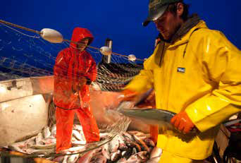
Annual Bristol Bay salmon runs average 38.7 million fish (20-year average, 1991-2010) (Jones et al. 2012). Commercial salmon harvests, which began in the 1880s, were recently valued at $1.5 billion and provided 10,000 full-time jobs (Figure 5) (Knapp et al. 2013). Sport fishing in Southcentral Alaska, which includes Bristol Bay, provided $387 million in income and 12,000 jobs in 2007 (Southwick Associates Inc. et al. 2008).
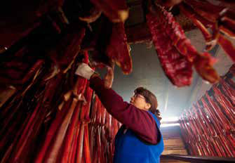
Salmon also represent food security and an important cultural heritage to 25 remote, largely Alaska Native communities (Figure 6); salmon comprise about 50 percent of their total annual wild food harvest (Fall et al. 2009).
NASA
Mine claims (Figure 2) near Lake Clark encompass about 750 square miles (1,942 square kilometers) and are located in headwaters of the Kvichak and Nushagak River watersheds. These watersheds comprise approximately 50 percent of the total Bristol Bay drainage and produce about 50 percent of Bristol Bay salmon (Jones et al. 2012). Concern for aquatic resource conservation increased during 2002-2007 as mineral exploration intensified; by 2007 more than 1,000 exploration drill cores had been drilled in Pebble claims alone (AKDNR 2013). Fisheries stakeholders were concerned exploration could alter water quality and potentially harm salmon (Woody et al. 2012).
However, mine proponents claimed neither salmon nor streams existed in the project area (Spence 2005, Bauman 2010).
Although three large rivers support salmon in the claims, few tributaries feeding them had ever been surveyed for fish (Woody and O’Neal 2010).
Michael Melford
The Alaska Department of Fish and Game (ADFG) estimates less than 50 percent of State freshwaters essential to anadromous (sea-run) fish, like salmon, are documented
(Figure 7) (ADFG 2014). However, in order for salmon habitat to receive some protections under The Anadromous Fish Act (AS 41.14.870-900) ADFG must “specify the various rivers, lakes and streams or parts of them” important to spawning, rearing, or migration of salmon and record those in the Anadromous Waters Catalogue (AWC) at which point they become subject to regulation (11 5 AAC 195.0110) (ADFG 2014).
Activities that can disturb or pollute documented salmon streams require an ADFG permit that can regulate activities to help avoid or minimize harm to salmon.
Unpermitted activities that harm documented salmon habitat are subject to fines or restoration requirements; water bodies not documented in the AWC are not protected.
Michael Melford
| Category | # Surveys |
|---|---|
| Salmon | 2 |
| Salmon & resident fish | 76 |
| Resident species only | 33 |
| No fish captured | 4 |
| Dry or no stream course | 18 |
| Unfishable (willow, alder, etc) | 4 |
| Total sites surveyed | 137 |
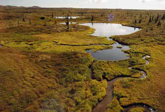
By 2008, it was clear that many potential salmon-bearing waters in mine claims were not a priority for fish surveys by the state or mine proponents. Therefore, beginning in 2008 a long-term study focused on wadeable streams of 10 percent gradient or less in and near mine claims was initiated. A 10 percent gradient was selected to stratify the survey effort because stream-rearing salmon generally do not occur in higher gradients (Figure 8)(Bryant et al. 2004). We focused on a census of likely salmon streams not already documented in the AWC. We selected 137 survey sites in and near mine claims (Figure 9), and also established five long-term monitoring sites to sample yearly for water quality, diatoms (algae), macroinvertebrates (aquatic insects), and fish.
Michael Melford
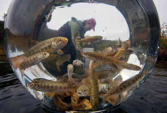
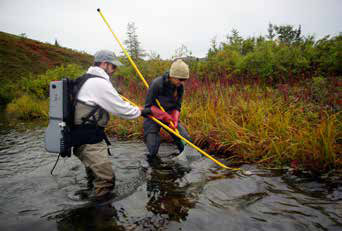
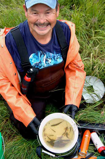
We surveyed streams during late August and early September 2008-2010. We fished with a backpack electrofisher (Figure 10), which attracts and momentarily stuns fish so they can be easily captured and sampled (Woody and O’Neal 2010). Water quality, including temperature, pH, oxygen, and conductivity (ability of water to conduct an electrical charge) were measured. We fished the survey site moving upstream and sampling all habitat types. Captured fish were kept in a bucket of fresh stream water until the entire reach was sampled (Figure 11); each reach measured 164 yards (150 meters) long or 40 times the stream width, whichever was longer.
We identified and counted fish and then measured all salmon and up to 20 non-salmon. All fish, were released unharmed back to the stream unless we could not identify them; these we took back to field camp to identify.
Carol Woody
We visited a total of 137 sites (Table 1); four sites were unfishable due to very dense willow or alder, and we did not capture fish at four sites; however, it is important to remember that this single survey is not proof that fish do not occur at these sites, only that fish were not documented during this single survey. They may occur at other times.
Steve Baird
We nominated more than 104 miles (168 kilometers) of essential salmon-rearing habitats, mainly small headwater streams, to the State Anadromous Waters Catalog for the first time (Woody and O’Neal 2010) including two salmon streams on the Pebble deposit. These streams will now receive increased regulatory oversight and protection if development or disturbance occurs.
Carol Woody
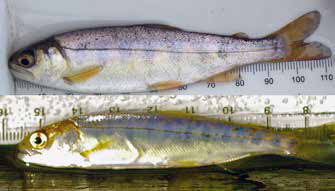
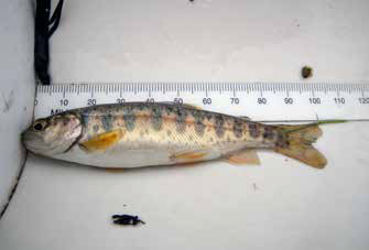
In tributaries draining to anadromous rivers, we documented salmon in three of every four streams surveyed (Figure 12); resident fish, such as rainbow trout (Figure 13) and Dolly Varden, were found in almost every stream surveyed.
Carol Woody
Surveyed streams averaged 13.2 feet wide (4.2 meters) with a maximum mean depth of 1.5 feet (0.45 meters) and a mean flow of 11.5 cubic feet per second (0.32 cubic meters per second). Waters were cold (mean=47.3 degrees Fahrenheit; 8.5 degrees Celsius), clear (mean=1.9 NTU), neutral (median pH= 7.2) oxygen saturated (mean=98.2%) with very low conductivity (mean=53.1 s/cm) indicating they are susceptible to mining impacts.
Collection of robust aquatic baseline data is essential to ensure aquatic resources important to food and economic security are adequately documented, monitored, and protected for future generations should mineral development proceed.
Carol Woody
References
ADFG (Alaska Department of Fish and Game). 2014.
Anadromous Waters Catalog. https://www.adfg.alaska.gov/sf/SARR/AWC/
AKDNR (Alaska Department of Natural Resources). 2013.
Pebble Mineral Prospect 1988-2013 Drilling Data. Div. of Mining, Land and Water.
Bauman, M. 2010.
Exploration continues as opponents decry project. The Bristol Bay Times.
Bryant, M.D., N.D. Zymonas, and B.E. Wright. 2004.
Salmonids on the Fringe: Abundance, species composition, and habitat use of salmonids in high-gradient headwater streams, Southeast Alaska. Transactions of the American Fisheries Society. 133 (6) 1529 – 1538.
Dye, J.E. and C.J. Schwanke. 2012.
Report to the Alaska Board of Fisheries for the recreational fisheries of Bristol Bay, 2010-2012. Alaska Department of Fish and Game. Special Publication No. 12-17.
Fall, J.A., T.M. Krieg, and D. Holen. 2009.
Overview of the subsistence fisheries of the Bristol Bay Management Area. Alaska Department of Fish and Game Division of Subsistence Special Publication No. BOF 2009-07.
Goonan, T.G. 2009.
Copper recycling in the United States in 2004. Chap. X of Sibley, S.R., Flow studies for recycling metal commodities in the United States. U.S. Geological Survey Circular 1196–X, p. X1–X30.
ICSG (International Copper Study Group). 2013.
The world copper fact book 2013. ICSG. Lisbon, Portugal. www.icsg.org
John, D.A. et.al. 2010.
Porphyry copper deposit model. Chapter B of Mineral de-posit models for resource assessment. U.S. Geological Survey Scientific Investigations Report 2010–5070–B, p. 169.
Jones, M., T. Sands, S. Morstad, P. Salamone, G. Buck, F. West, T. Baker, and T. Krieg. 2012.
2011 Bristol Bay area annual management report. Alaska Department of Fish and Game. Fishery Management Report No. 12-21.
Knapp, G., M. Guettabi, and S. Goldsmith. 2013.
The economic importance of the Bristol Bay salmon industry. Institute of Social and Economic Research. University of Alaska, Anchorage. www.iser.uaa.alaska.edu/
Papp, J.F. 2013.
2011 Minerals Yearbook. Recycling, Metals. Dept. of the Interior. U.S. Geological Survey 6.12 (Advance Release) https://minerals.usgs.gov/minerals/pubs/commodity/recycle/
Southwick Associates Inc. and W.J. Romberg, A.E. Bingham, G.B. Jennings, and R.A. Clark. 2008.
Economic impacts and contributions of sportfishing in Alaska, 2007. Alaska Department of Fish and Game. Professional Publication No. 08-01.
Szumigala, D.J. 2012.
Alaska’s mineral industry 2011 - exploration activity: Alaska Division of Geological & Geophysical Surveys Special Report. 67, p. 10.
Spence, H. 2005.
Lake dumping in Pebble’s future? Peninsula Clarion. July 5. http://peninsulaclarion.com/stories/070505/news_0705new002001.shtml
USEPA (U. S. Environmental Protection Agency). 2014.
An assessment of potential mining impacts on salmon eco-systems of Bristol Bay, Alaska (Final Report). U.S. EPA. Wash. D. C. EPA 910-R-14-001A-C, ES, 2014.
Woody, C.A. and S. O’Neal. 2010.
Fish surveys in headwater streams of the Nushagak and Kvichak River drainages Bristol Bay, Alaska, 2008-2010. Fisheries Research & Consulting for The Nature Conservancy. http://www.pebblescience.org/reports.html
Woody, C.A., K. Zamzow, M. Welker, and S. O’Neal. 2012.
Water Quality at Pebble Prospect Drill Rig #6, South Fork Koktuli River, Bristol Bay, Alaska 22-23 Oct. 2011. Fisheries Research & Consulting. Anchorage, Alaska. http://www.pebblescience.org/reports.html
Part of a series of articles titled Alaska Park Science - Volume 13 Issue 2: Mineral and Energy Development.
Last updated: June 15, 2015
