This article describes the basis for and application of a GIS-based approach to assessing installations in the national parks in Alaska. Baseline maps of installations in wilderness allow park staff to more effectively determine cumulative effects to the undeveloped quality of wilderness character as staff evaluate requests for additional installations. Managers can reduce impacts by considering mitigation measures and by following a four-step process for reducing cumulative impacts.
Purpose of Wilderness
The overarching mandate of the Wilderness Act is to preserve wilderness character. Wilderness character is composed of five qualities that directly link agency stewardship and wilderness conditions to the statutory language of the 1964 Wilderness Act and NPS policy (NPS 2006), and apply to every wilderness regardless of size, location, agency administration, or other attribute.
These qualities of wilderness character are:
- Natural – wilderness ecological systems are substantially free from the effects of modern civilization.
- Solitude or primitive and unconfined recreation – wilder-ness provides outstanding opportunities for solitude or primitive and unconfined recreation.
- Undeveloped – wilderness retains its primeval character and influence, and is essentially without permanent im-provement or modern human occupation. Untrammeled – wilderness is essentially unhindered and free from the actions of modern human control or ma-nipulation.
- Other Features – tangible features that provide scientific, educational, scenic, or historical value to the wilderness.
The Wilderness Act identifies six public purposes of wilderness: “recreational, scenic, scientific, educational, conservation, and historical use” (Public Law 88-577, Sec. 4. (b)). The act also prohibits temporary roads, motor vehicles, motorized equipment, landing of aircraft, structures, and installations “except as necessary to meet minimum requirements for the administration of the area for the purpose of this act (including measures required in emergencies involving the health and safety of persons within the area)” (Public Law 88-577. 4. (c)).
The Alaska National Interest Lands Conservation Act (ANILCA) modifies certain provisions in the Wilderness Act for Alaska conservation system units by allowing certain types of motorized transportation methods, access to and use of subsistence resources, and certain types of installations and structures. However, even though a use or activity is legal, it may still degrade wilderness character.
The challenge for wilderness managers in Alaska is to preserve an area’s wilderness character in light of the special provisions found in ANILCA and in spite of exceptions the agency may make to Section 4(c) in its administration of the wilderness unit.
NPS Photo / Bob Winfree
Preserving the Undeveloped Quality of Wilderness Character
The undeveloped quality of wilderness character runs through every definition of wilderness. The Wilderness Act states that wilderness is “an area of undeveloped federal land retaining its primeval character and influence, without permanent improvements or human habitation,” “where man himself is a visitor who does not remain” and “with the imprint of man’s work substantially unnoticeable.” This quality is degraded by the presence of structures, installations, habitations, and by the use of motor vehicles, motorized equipment, or mechanical transport that increases people’s ability to occupy or modify the environment (Landres et al. 2008).
NPS Images
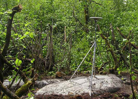
Installations are one of the main factors that degrade the undeveloped quality. The term installation is commonly understood to include site markers, ecological monitoring instruments, communications facilities, and navigation-related facilities. In fact, it includes any object that is assembled or created outside the wilderness and is left behind when the installer leaves the wilderness.
In order to preserve the undeveloped quality and wilderness character as a whole, agencies must track changes to the undeveloped quality over time. Landres et al. (2005) developed a methodology for tracking change in wilderness character. This methodology has been refined specifically for the NPS in the 2013 NPS Wilderness Character User Guide. The first step in tracking change in the undeveloped quality is to identify a baseline condition for the elements that comprise it. The baseline for comparison could hypothetically be at any point for which reliable data is available. It could, for example, include data from resource inventories, historic maps and photos, administrative records, and local and traditional knowledge.
NPS Photo
Establishing a Baseline for the Undeveloped Quality of Wilderness Character
While the effects of individual activities may sometimes seem minor by themselves, accumulated small effects can be significant. During the early 2000s, NPS Alaska Region superintendents expressed concern over the growing number of installations in wilderness and their cumulative effect on wilderness character. Acting on the recommendations of the NPS Alaska Region Science in Wilderness Workgroup, and under the direction of the Alaska Leadership Council, the region began in 2010 to develop a GIS database of all known installations in parks, including relevant information for determining intrusiveness. As the regional GIS team began its work, high priority was given to documenting larger, more obtrusive, and higher-tech types of wilderness installations (Table 1).
Existing datasets and GIS data layers as well as interviews with park staff were used to identify locations of known installations, while recognizing that the first generation of maps would likely underestimate the actual number of installations. An initial geodatabase was developed and released for use. Table 2 shows an example of the type of data that was collected for each installation.
The number of documented installations is expected to increase with time, as more pre-existing installations are recorded and added to the database. Distinguishing between newly documented and newly created installations is also important for determining whether a new data point simply adjusts the baseline or is considered to be an additive effect.
NPS Photo
Types of installations included in the geodatabase:
- Communication Systems
- Geologic Monitoring Stations
- Weather and Climate Monitoring Stations
- Navigation Related Facilities
- River / Water Gauge Stations
- Webcams
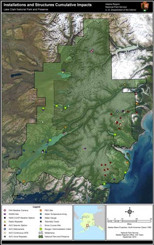
Baseline maps of installations in wilderness allow park staff to more effectively determine cumulative effects (CEQ 1997) to the undeveloped quality of wilderness character as staff evalu-ate proposals that include additional installations (Figure 1).
| Field Name | Field Value | Notes |
|---|---|---|
| Installation_Type | Weather/Climate | |
| Installation_Subtype | SNOTEL Station | |
| Installation_Physical_Des | Installation consists of an 8 ft tall shelter house, 10 ft tall alter shield precipitation gage, 8 ft tall MET tower with attached equipment, and a 6 ft wide hypalon snow pillow. | |
| Installation_Purpose_Desc | Snowpack and climate monitoring | |
| Installation_Name | McNeil Canyon | |
| Installation_ID | 51K14 | |
| Installation_Status | Installed – good condition. | |
| Installation_Setting | Set in ground | |
| Installation_Width_FT | 50 | Width of cumulative site footprint. |
| Installation_Length_FT | 50 | Length of cumulative site footprint |
| Installation_Height_FT | 10 | . Height of the tallest site component |
| Relation_To_Surface | Above Surface | |
| Installation_Organization | USDA, Natural Resources Conservation Service | |
| NPS_Program_Name | SWAN Inventory and Monitoring | |
| Actual_Install_Date | 08/01/1986 | |
| Has_Seasonal_Deployment | No | |
| Seasonal_Deployment_Desc | n/a | |
| Removal_Is_Anticipated | No | |
| Expected_Removal_Date | ||
| Actual_Removal_Date | ||
| Geometry_ID | {FFFD8575-E4DA-4DE7-A9CE-3197978CBCB5} |
aps-v13-i1-c14-s6
NPS Photo
Mitigating and Reducing Impacts to the Undeveloped Quality of Wilderness Character
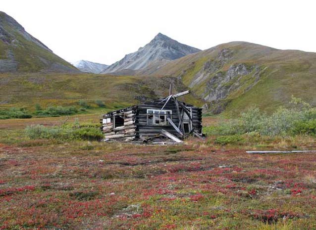
The first opportunity to mitigate cumulative impacts and help preserve the undeveloped quality of wilderness character is by reducing the potential for incremental impacts, and preferably by working cooperatively in the initial stages of developing project proposals. While even the smallest long-term placements of markers or instruments are installations, their effects on wilderness character can be quite different from larger installations (Figure 2). There is a substantial body of knowledge and a number of highly successful examples of ways to minimize the physical and ecological impacts of installations, as well as to make their visual and auditory imprint “substantially unnoticeable.” The definitions provided by Landres et al. (2010) suggest ways for reducing use of visibly unnatural components to minimize installation effects. Site-specific design is typically part of the “cost of doing business” when considering large and critical installations in areas of significant public use, and should be for wilderness as well. When the estimated costs of concealment are factored into early planning, there may also be more consideration of alternative sites that might at first be dismissed as infeasible.
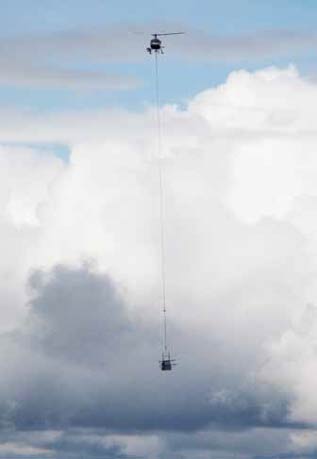
The most obvious opportunity for reducing the impacts of installations would be a unified effort to avoid adding unnecessary new installations, removal of nonfunctional or obsolete installations, and replacement of individual installations with others that serve multiple functions while meeting the needs of multiple users. Doing so can largely be a question of opportunity and expense when all the components are owned and used by the NPS. However, some are installed and operated by other stakeholders, including agencies, institutions, and scientists, with permission from the NPS. Trust and equity are important considerations under such conditions, because such installations can involve major professional and budgetary investments. Some also serve public safety needs. Unilateral decisions to remove operable installations without clear cause can have chilling and long-lasting effects on NPS relationships and impact future ability to attract cooperators for work in wilderness areas. Placing a moratorium on new installations, an arbitrary cap on the total number of installations, or imposing unreasonably short permit durations for long-term installations could also be viewed unfavorably by cooperators.
NPS Photo
Steps for Reducing Cumulative Impacts from Installations
The Science in Wilderness Workgroup proposed a four-step process and several related questions for reducing cumulative impacts from installations.
- Evaluate the Purpose and Need
Is the installation necessary for management of the area as wilderness? If so, how?
Is the installation expected to reduce future impacts to other qualities of wilderness character? If so, how?
- Evaluate the Location and Design
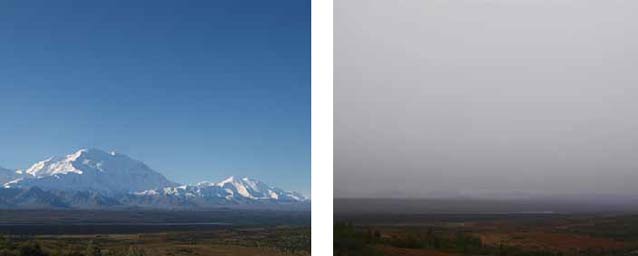
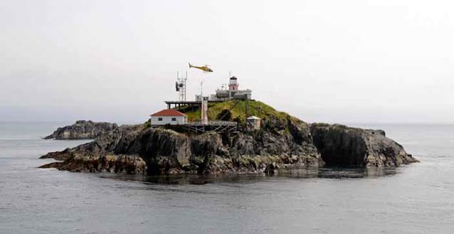
Could the primary purposes be accomplished by an installation outside of wilderness (Figure 3)?
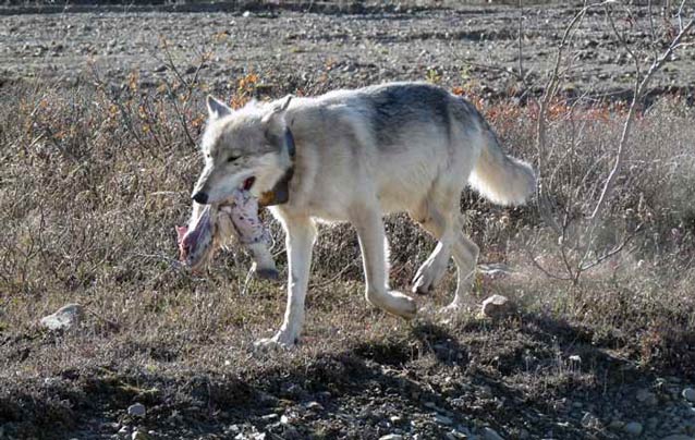
Could potential impacts of installations be mitigated through alternative locations (or co-location with other installations) that would reduce frequency of encoun-ters by visitors and wildlife or reduce transportation needs to service the installation (Figure 4)?
Could the potential impacts be mitigated through design features to make it “substantially unnoticeable” or to reduce the frequency of maintenance (Figures 5 and 6)?
Are their opportunities for co-location or relocation of installations by NPS staff and cooperators (Figure 7)?
- Bring Aging Installations “Up to Code”
Stipulations for existing installations should be re-evaluated during re-permitting (generally at least every five years), or possibly earlier if the permittee requests permit amendments for major upgrades or replacement of components. Re-permitting provides opportunities to better document existing installa-tions and consider removal of obsolete installations, consolidation with other installations where practical, or modifications to reduce visual or other impacts.
- Removing Abandoned and Inoperable Installations
Stipulations for all new permits for installations should require that they be indelibly marked or permanently tagged with contact and permit informa-tion, with map coordinates and photos of the actual installation to be provided to the permit office. Permit stipulations, correspondence, and documentation in the permanent project file should identify who is re-sponsible for final removal and site restoration. Com-munications with permittees should include checking on the status of existing installations before the permits expire and before issuing additional permits.
Summary
It is important to remember that many exceptionally valuable studies are only possible today, because the current generation of scientists was able to precisely relocate benchmarks, monuments, plot markers, survey points, and exclosures that were installed by their predecessors, not always with thought for longer-term studies. Numerous new studies that rely on instrumentation provide valuable information about wilderness resources. However, managers must be vigilant about preserving the undeveloped quality and wilderness character as a whole. Over time, any effort that succeeds in reducing the incremental effects of a new activity or installation will also reduce cumulative effects. Parks should establish an appropriate baseline and benchmarks to which the effects can be compared. While baselines can be established for any point at which data is available, the most relevant benchmarks relate to “desired conditions” identified in current management plans.
References
Council on Environmental Quality (CEQ). 1997. Considering cumulative effects under the National Environmental Policy Act. Council on Environmental Quality. Executive Office of the President of the United States. http://ceq.hss.doe.gov/nepa/ccenepa/toc.pdf
Landres, P., C. Barns, J. Dennis, T. Devine, P. Geissler, C. McCasland, L. Merigliano, J. Seastrand, and R. Swain. 2008.
Keeping it wild: an interagency strategy to monitor trends in wilderness character across the National Wilderness Preservation System. Gen. Tech. Rep. RMRS-GTR-212. Fort Collins: U.S. Department of Agriculture, Forest Service, Rocky Mountain Research Station. 77 p.
Landres, P., S. Boutcher, L. Merigliano, C. Barns, D. Davis, T. Hall, S. Henry, B. Hunter, P. Janiga, M. Laker, A. McPherson, D.Powell, M. Rowan, and S. Sater. 2005.
Monitoring selected conditions related to wilderness character: a national framework. General Technical Report, RMRS-GTR-151. Fort Collins:U.S. Forest Service Rocky Mountain Research Station.
Landres, P., M. Fincher, and L. Sharman. 2010.
A framework to evaluate proposals for scientific activities in wilderness. General Technical Report RMRS GTR-234WWW. 74 p. Fort Collins, Co: U.S. Department of Agriculture, Forest Service, Rocky Mountain Research Station.
National Park Service. 2006.
Management Policies 2006. U.S. Department of the Interior, National Park Service. https://www.nps.gov/policy/mp2006.pdf
Public Law 88-577 (16 U.S. C. 1131-1136). 1964.
An Act To establish a National Wilderness Preservation System for the permanent good of the whole people, and for other purposes.
Public Law 96-487 (94 Stat. 2371). 1980.
Alaska National Interest Lands Conservation Act. 2013 National Park Service Wilderness Character User Guide.
Part of a series of articles titled Alaska Park Science - Volume 13 Issue 1: Wilderness in Alaska.
Last updated: August 13, 2015
