Photograph courtesy of De Anne Stevens
Introduction: Fire and Ice
The Alaska Peninsula hosts a chain of glacier-clad volcanoes that generally hug the southern coastline of the peninsula. More than 50 percent of the Alaska Peninsula is composed of Quaternary-age deposits (younger than about 2.6 million years) that are primarily glacial or volcanic in origin. Pleistocene (between 2.6 million and 11,700 years) ice caps and glaciers blanketed much of the peninsula with glacial deposits, with most preserved deposits being of Wisconsin age (between about 110,000 and 11,700 years) or younger (Detterman 1986).
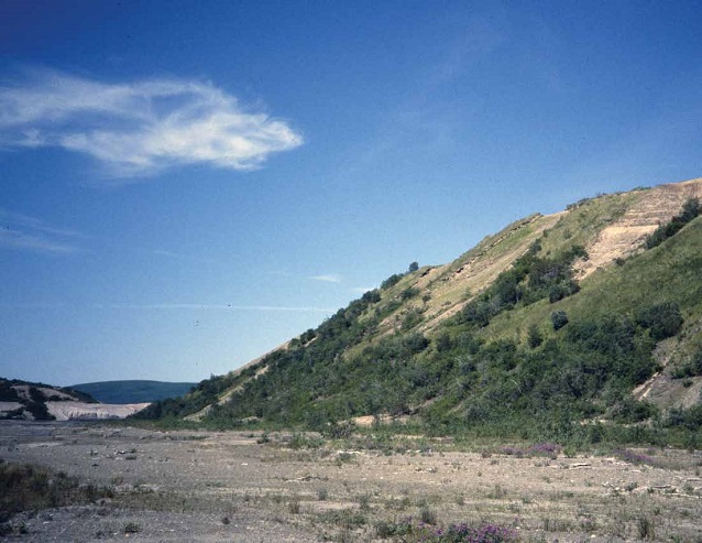
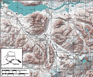
One of the most notable chapters in the recent geologic history of the Alaska Peninsula took place in 1912, when a major ignimbrite-producing eruption occurred in the Katmai area. Much has been published on the 1912 Katmai eruption, but much less well known are the geologic events preceding that event. Here I discuss pre-1912 surficial deposits of the Katmai area and develop a Quaternary geologic history of the region. The study area is centered on Windy Creek valley, just west of the Valley of Ten Thousand Smokes, and includes Overlook Mountain (Figure 1).
Glacial Deposits
Prior to Quaternary time, the Alaska Peninsula southwest of Port Heiden was a string of islands (Detterman 1986), much like today’s Aleutians. During the Pleistocene these islands were connected first by ice, then by the deposits left behind by repeated glaciations. Located adjacent to the Gulf of Alaska, a vast moisture source, the Alaska Peninsula was ideally situated to produce large glaciers. During times of maximum glaciation, an ice cap in Shelikof Strait sent outlet glaciers north through passes in the Aleutian Range to the coastal plain along Bristol Bay and south into valleys on Kodiak Island, burying the peninsula in ice (Péwé 1975).
Pleistocene glacial deposits recognized on the Alaska Peninsula include an unnamed pre-Wisconsinan drift, pre-Wisconsinan Johnston Hill drift, early Wisconsinan Mak Hill drift, and late Wisconsinan Brooks Lake drift (Muller 1952, 1953, Detterman and Reed 1973, Detterman 1986). The Brooks Lake Glaciation has been subdivided into four substages, or stades (from oldest to youngest): the Kvichak, Iliamna, Newhalen, and Iliuk (Muller 1952, 1953, Detterman and Reed 1973, Detterman 1986). In the Katmai area, ice of the Iliamna, Newhalen and Iliuk stades extended 60 mi, 45 mi, and 30 mi (100 km, 70 km, and 50 km), respectively, downvalley from modern glaciers with the type Iliuk moraine forming the narrows separating Iliuk Arm from Naknek Lake (Riehle and Detterman 1993).
Photograph courtesy of De Anne Stevens
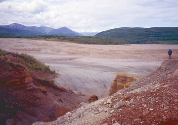
Glacial deposits of probable Iliamna and Newhalen age are locally exposed in Windy Creek valley, which was subsequently dammed by Iliuk ice to form a proglacial lake. In the study area, Iliuk drift is best preserved in Overlook valley (informal name), the east-west trend-ing valley immediately south of Overlook Mountain. Glaciers in the Valley of Ten Thousand Smokes flowed west through Overlook valley during Iliuk time and blocked drainage in Windy Creek valley. Glacial-lake deposits form bluffs up to 130 ft (40 m) high along the margins of the river floodplain (Figure 2). The upper surface forms a terrace up to 0.3 mi (0.5 km) wide on either side of the valley and extends more than 3.7 mi (6 km) upvalley. Maximum height of the Iliuk moraine exceeds 165 ft (50 m) at the mouth of Windy Creek.
Two late-stage readvances of Iliuk ice were recognized in the Windy Creek area. The older of these was informally named “Ukak drift” (Pinney and Begét 1991a, Pinney 1993). Ukak drift represents a late Pleistocene ice readvance and is preserved in upper Margot Creek and lower Windy Creek. The upper part of associated glacial-lake deposits date between ca. 10,000-12,000 radiocarbon years before present (RC yr B.P.) (Pinney and Begét 1991a, Pinney 1993). Alpine glaciers in Windy Creek did not advance all the way down the valley during this time, leaving the earlier glacial deposits intact. In the Valley of Ten Thousand Smokes, Ukak-age glaciers advanced several kilometers beyond Overlook Mountain and a tongue of ice extended past the mouth of Windy Creek. There is no evidence of an ice-dammed lake in Windy Creek valley during this time, but Windy Creek drainage was at least intermittently impounded in Overlook valley prior to draining to the west.
The youngest glacial deposits recognized in the lower Windy Creek area are informally named “Katolinat drift” (Pinney and Begét 1991a, Pinney 1993), and form a nested pair of well-formed, modestly-sized terminal moraines (Figure 3). Katolinat-age glaciers advanced down the Valley of Ten Thousand Smokes almost as far as glaciers did during Ukak time. Windy Creek drainage was diverted by the ice margin and once again dammed to form a small lake in Overlook valley. Katolinat drift is best exposed along the 2.5 to 3.1 mi (4-5 km) reach of Windy Creek immediately south of Three Forks, where moraine ridges overrun by the 1912 ashflow can be clearly seen in the canyon walls. Katolinat moraines extend across the lower Valley of Ten Thousand Smokes and obstructed the flow of the ignimbrite, funneling it against the base of Overlook Mountain. The early Holocene (younger than 11,700 years) Katolinat drift dates between ca. 8,500 and 10,000 RC yr B.P. (Pinney and Begét 1991a, Pinney 1993).
Photograph courtesy of De Anne Stevens
Volcanic Deposits
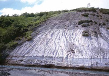
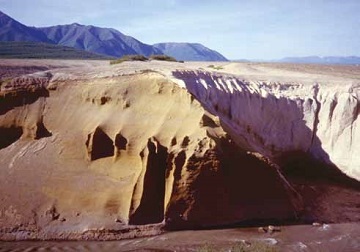
Ranging from massive ignimbrites that may have rivaled or even exceeded the 1912 deposit to thin layers of the finest ash, the Windy Creek area preserves an extensive record of volcanism. Deposits of a pre-1912 rhyolitic ashflow are exposed on the west side of lower Windy Creek valley (Figure 4). Hildreth et al. (2003) map correlative ashflow deposits in Mageik Creek that are dated to 19,240 ±70 RC yr B.P. and posit that the plinian eruption generating these deposits might have been greater in magnitude than that of 1912. The source of these deposits is probably Mount Katmai (Hildreth et al. 2003).
In the figure at the right, diagonal fractures are interpreted as clastic dikes resulting from the weight of overriding ice when glaciers advanced during the Newhalen stade of the Brooks Lake Glaciation. Exposure is approximately 70 ft (21.5 m) high.
Photograph courtesy of De Anne Stevens
The informally named Lethe volcaniclastic deposits (Pinney and Begét 1990, 1991a, 1991b; Pinney 1993) comprise an extensive suite of dacitic deposits, including pyroclastic flows, lahars, lahar-runout flows, and primary and reworked fallout tephra. These deposits are exposed in river gorges in the Valley of Ten Thousand Smokes as far as 1.0 mi (1.5 km) upvalley from the mouth of Windy Creek and extend about 3.1 mi (5 km) past Windy Creek in Overlook valley (Figure 5). Lethe deposits overlie Iliuk drift in the Windy Creek area and are overlain by and incorporated into Ukak and Katolinat drifts (Pinney and Begét 1991b, Pinney 1993). Organic silt immediately underlying the younger glacial deposits yields a minimum age of 12,640 ±100 RC yr B.P. for Lethe deposits (Pinney and Begét 1991a, Pinney 1993). Hildreth et al. (2003) correlate the Lethe volcaniclastics to a remnant of a proximal pumice-and-scoria fall in the Katmai caldera rim, suggesting that the deposits were erupted from Mount Katmai. Lethe ash has been used as an important stratigraphic marker horizon at Iliamna and Naknek lakes (Kaufman and Stilwell 1997), and 185 mi (300 km) away on the Kenai Peninsula (Reger et al. 1996). Organic material beneath the Lethe tephra on the Kenai Peninsula gives a maximum age for the tephra of 16,480 ±170 RC yr B.P. (Reger et al. 1996), and lake-core studies in lower Cook Inlet suggest a minimum age of 13,730 RC yr B.P. (Rymer and Sims 1982, Riehle et al. 2008). These dates correlate well with the minimum date from the Windy Creek area and indicate that the Lethe volcaniclastics were erupted between about 16,600 and 13,730 RC yr B.P.
Other volcanic deposits in the Windy Creek area include numerous individual ash layers whose origins and correlations remain largely unknown, with a few notable exceptions. Distal ash from the caldera-forming eruption of Aniakchak Crater (ca. 3,400 RC yr B.P.), 140 mi (230 km) away, was preserved in one Windy Creek sample site. Another tephra, ash “Y”, correlates with proximal deposits 100 mi (160 km) away at Augustine volcano that date approximately 1,700 RC yr B.P. (J.E. Begét, personal communication).
Summary of pre-1912 Geologic History
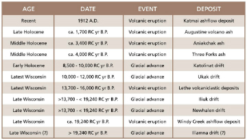
Figure 6 illustrates the pre-1912 geologic history of the Windy Creek area summarized in Figure 7. The oldest recognized Quaternary deposits are sediments believed to have been deposited during the late Wisconsinan Iliamna glacial advance. An eruption at the Mount Katmai volcanic center buried Windy Creek valley in thick ashflow deposits, which were subsequently overridden and deeply incised by glacial ice of the Newhalen stade and then buried by drift. Another late Wisconsinan ice advance, the Iliuk, blocked drainage from Windy Creek and dammed a lake in the valley, leaving thick glaciolacustrine deposits in addition to well-preserved lateral moraines. Sometime between approximately 16,000 and 13,730 RC yr B.P., another major volcanic eruption, the Lethe, which probably originated at Mount Katmai, deposited a wide variety of volcaniclastic deposits over much of the area. Winds carried Lethe ash across Cook Inlet to blanket large parts of the western Kenai Peninsula. Alpine glaciers advanced between 10,000 and 12,000 RC yr B.P. and deposited the Ukak drift. A glacial readvance between 8,500 and 10,000 RC yr B.P. may have occurred in response to a brief period of climatic cooling, depositing the early Holocene Katolinat drift. The remainder of the Holocene record is characterized by deposition of tephra-rich eolian silts and multiple discrete ash layers that record eruptions from distant sources such as Aniakchak caldera and Augustine volcano.
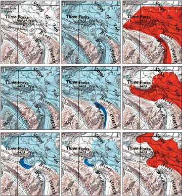
Figure 6. Late Quaternary paleogeography of the Windy Creek area. Light blue – glacial ice; dark blue – glacially dammed lakes; red – volcanic deposits. a) location map with key geographic features; b) Late Wisconsin Iliamna stade glacial advance; c) Windy Creek ashflow eruption ca. 19,240 RC yr B.P.; d) Newhalen stade glacial advance; e) Iliuk stade glacial advance dams glacial lake in lower Windy Creek; f) Lethe volcanic eruption ca. 14,000-16,000 RC yr B.P.; g) Ukak glacial readvance dams small lake in Overlook valley ca. 10,000-12,000 RC yr B.P.; h) Katolinat glacial readvance dams small lake in Overlook valley ca. 8,500-10,000 RC yr B.P.; i) 1912 cataclysmic eruption forms Valley of Ten Thousand Smokes.
References
Detterman, R.L. 1986. Glaciation of the Alaska Peninsula. In Glaciation in Alaska: The geologic record, edited by T.D. Hamilton, K.M. Reed, and R.M. Thorson, pp. 151-170. Alaska Geological Society.
Detterman, R.L., and B.L. Reed. 1973. Surficial deposits of the Iliamna quadrangle, Alaska. U.S. Geological Survey Bulletin. 1368-A: A1-A64
Hildreth, Wes, Judy Fierstein, J.E. Robinson, D.W. Ramsey, and T.J. Feldger. 2003. Geologic map of the Katmai volcanic cluster, Katmai National Park, Alaska. U.S. Geological Survey Geologic Investigations 2778.
Kaufman, D.S., and K.B. Stilwell. 1997. Preliminary evaluation of emergent postglacial shorelines, Naknek and Iliamna lakes, Southwestern Alaska. In Geologic studies in Alaska by the U.S. Geological Survey, 1995, edited by J.A. Dumoulin and J.E. Gray, pp. 73-81. U.S. Geological Survey Professional Paper 1574.
Muller, E.H. 1952. Glacial history of the Naknek District, Alaska Peninsula, Alaska [abstract]. Geological Society of America Bulletin 63: 1284.
Muller, E.H. 1953. Northern Alaska Peninsula and eastern Kilbuck Mountains, Alaska. In Multiple glaciation in Alaska: A progress report, edited by T.L. Péwé, pp. 2-3. U.S. Geological Survey Circular 289.
Péwé, T.L. 1975. Quaternary geology of Alaska. U.S. Geological Survey Professional Paper 835: 145.
Pinney, D.S. 1993. Late Quaternary glacial and volcanic stratigraphy near Windy Creek, Katmai National Park, Alaska. M.S. thesis. University of Alaska Fairbanks.
Pinney, D.S., and J.E. Begét. 1990. Quaternary tephrochronology near the Valley of Ten Thousand Smokes, Katmai National Park, Alaska [abstract]. EOS, Transactions, American Geophysical Union 71(43):1721.
Pinney, D.S., and Begét, J.E. 1991a. Deglaciation and latest Pleistocene and early Holocene glacier readvances on the Alaska Peninsula: Records of rapid climate change due to transient changes in solar intensity and atmospheric CO2 content? Proceedings of International Conference on the Role of the Polar Regions in G1obal Change. Pp. 634-640.
Pinney, D.S., and Begét, J.E. 1991b. Late Pleistocene Volcanic deposits near the Valley of Ten Thousand Smokes, Katmai National Park, Alaska. In Short Notes on Alaskan Geology, edited by R.D. Reger, pp. 45-53. Alaska Division of Geological & Geophysical Surveys Professional Report 111.
Reger, R.D., D.S. Pinney, R.M. Burke, and M.A. Wiltse. 1996. Catalog and initial analyses of geologic data related to Middle to Late Quaternary deposits, Cook Inlet region, Alaska. Alaska Division of Geological & Geophysical Surveys Report of Investigation 95-6.
Riehle, J.R., and R.L. Detterman. 1993. Quaternary geologic map of the Mount Katmai Quadrangle and adjacent parts of the Naknek and Afognak quadrangles, Alaska. U.S. Geological Survey Miscellaneous Investigations 2032.
Riehle, J.R., T.A. Ager, R.D. Reger, D.S. Pinney, and D.S. Kaufman. 2008. Stratigraphic and compositional complexities of the late Quaternary Lethe tephra in South-central Alaska. Quaternary International 178(1): 210-228.
Rymer, M.J., and J.D. Sims. 1982. Lake-sediment evidence for the date of deglaciation of the Hidden Lake area, Kenai Peninsula, Alaska. Geology 10: 314-316.
Part of a series of articles titled Alaska Park Science - Volume 11 Issue 1: Volcanoes of Katmai and the Alaska Peninsula.
Last updated: June 23, 2016
