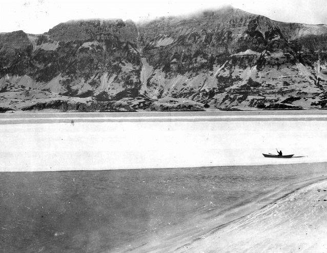
Photograph courtesy of George C. Martin
Volcanic eruptions are infrequent disturbance events that vary in magnitude and type, which effects how ecosystems respond to these disturbance events (DeGange et al. 2010). Southwestern Alaska has been shaped and reshaped by these events over many centuries, for it resides in the Pacific Ring of Fire, an area where the Pacific Plate of the earth’s crust is slowly subducting under the North American Plate. These events also influence the biological environment of the nearshore ecosystem. Here, a brief overview of the literature and recent field accounts are summarized from three volcanic eruptions that occurred on the Alaska Peninsula. These three eruptions, which differed greatly in magnitude and type, are presented to illustrate the range of effects that these eruptions have on the nearshore marine ecosystem.
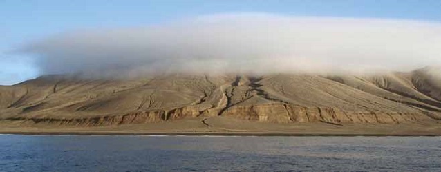
USGS photograph by George Esslinger, Alaska Science Center
Novarupta-1912
In 1912, Novarupta erupted in what is now Katmai National Park and Preserve (NPP) and was the largest volcanic eruption of the twentieth century (Fierstein and Hildreth 2001). After the eruption, initial accounts on the effects to the marine environment primarily discussed the amount of ash and pumice deposited. One account described Kaflia Bay, along the coast, as being so choked with several feet thick of floating pumice that birds, fish, and marine mammals were actually floating on the surface of the ash and pumice mixture (Schaaf 2004). Extensive fields of floating pumice were observed in other areas as well, and witnesses claimed floating pumice mats were so thick that they could support the weight of a man (Figure 1) (Martin 1913).
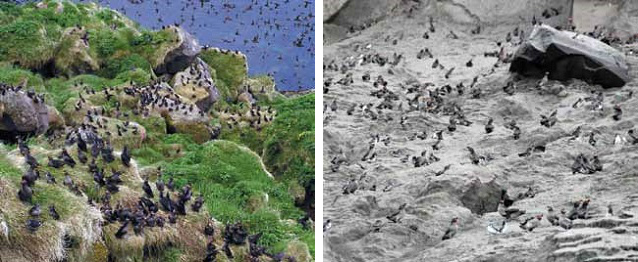
Left photo: USGS photograph by Gary Drew, Alaska Science Center. Right photo: USGS photograph by Gary Drew, Alaska Science Center.
Ash deposits along the shoreline most likely buried existing marine plants and were still evident a year after the eruption (Rigg 1914). Intertidal and subtidal canopy kelps most likely succumbed to the grinding effect of the floating pumice, exacerbated by waves and tidal action. Two kelps, Nereocystis luetkeana (bull kelp) and Eualaria fistulosa (formally Alaria fistulosa) (dragon kelp), were of particular importance to the livelihoods of local residents. Both of these kelps were used as navigation aids to indicate areas of shallow water and as fertilizer for gardens (Rigg 1914). Besides the grinding effects of floating pumice on kelps, marine plants as well as the rocks many marine plants attach to, were buried, possibly permanently altering the quantity of available kelp forest habitat.
The immediate impacts of the Novarupta eruption resulted in substantial changes in the marine ecosystem. We cannot say with certainty how these physical changes affected the complex biological balance of flora and fauna, but the loss of the kelp beds, nearshore plants and sessile invertebrates altered the complex balance for many years following the eruption and caused Alaska Natives to abandon coastal settlements (Schaaf 2004). However, Rigg (1914) noted that the effects on marine vegetation from this eruption were most likely temporary, as tide, waves, wind and other natural forces eroded ash deposits in the nearshore, allowing the ecosystem to recover.
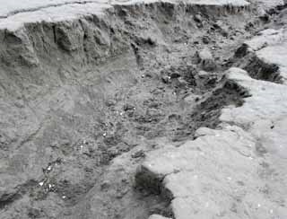
USGS photograph by Gary Drew, Alaska Science Center
Kasatochi-2008
Kasatochi, an island in the Aleutian chain, erupted for two days in August of 2008 (DeGange et al. 2010, Scott et al. 2010). Pyroclastic flows decimated the entire terrestrial portion of the island, devastated marine nearshore habitats to the 66 ft (20 m) isobath, and actually increased the size of the terrestrial portion of the island by approximately 30% (Scott et al. 2010, Jewett et al. 2010) (Figure 2). Algal and faunal communities as well as rocky substrates were buried with volcanic deposits, well into the subtidal zone. These deposits not only destroyed existing plants but also severely limited rocky habitat through burial. The loss of this rocky habitat may constrain kelp recolonization around Kasatochi. However, little information is known regarding ocean current directions and velocities that may ultimately help erode soft-sediments and expose hard substrates necessary for kelp bed recolonization (Jewett et al. 2010).
Higher trophic marine organisms were also affected by the eruption. Prior to eruption, Kasatochi provided foraging and breeding habitat for many species of seabirds and marine mammals (Williams et al. 2010). Nesting habitat for several species of auklets was covered in meters of tephra. Adults returned in 2009 to former colony areas and attempted to nest and lay eggs (Figure 3) (Williams et al. 2010). Researchers found broken, non-predated eggs scattered and in the open at these former colonies (Figure 4) (Williams et al. 2010). While post-eruption densities of adult seabird populations were similar to pre-eruption densities, the present lack of suitable nesting habitat could have negative impacts on future seabird populations on Kasatochi (Drew et al. 2010). This eruption has given scientists a unique opportunity to examine rates and processes of successional recovery (DeGange et al. 2010).
NPS photograph by Heather Coletti
Redoubt-2009
In 2009, Redoubt volcano, west of Cook Inlet in Lake Clark National Park and Preserve (NPP), erupted creating an ash cloud 30,000 - 60,000 feet above sea level (Carlisle and Nelson 2009). Ash deposits were visible in terrestrial upland areas, but a light coating of ash was also observed in the intertidal (Coletti, personal observation). Ash deposited in the nearshore environment was considered minor, resulting in short-term impacts to the flora and fauna of the nearshore marine ecosystem (Figures 5-6).
However, a major threat to the nearshore from the Redoubt eruption was the formation of a lahar (a flow of pyroclastic material mixed with water), that flooded the Drift River valley. The mouth of the river is home to the Drift River Oil Terminal, which has a crude oil storage capacity of several million gallons. The mouth of Drift River opens into Cook Inlet, whose waters run along shore of Lake Clark NPP and Katmai NPP. These park shorelines, as well as adjacent areas, support a variety of marine flora and fauna that interact in a complex food web—beginning with primary production from kelps and sea grasses, to primary consumers such as mussels and limpets, to apex predators such as seabirds and marine mammals (Dean and Bodkin 2011). Ample evidence collected over several decades since the 1989 Exxon Valdez Oil Spill in Prince William Sound, Alaska, has demonstrated that species and ecosystems immediately affected by the oil spill have not fully recovered in the twenty plus years since the spill (Peterson 2001, Rice et al. 2007). An oil spill along the Katmai NPP and Lake Clark NPP coastlines could exacerbate and protract the process of recovery to a system responding to natural and anthropogenic change.
Photograph by Susan Saupe, Cook Inlet Regional Citizens Advisory Council
The unpredictability of catastrophic events as well as anticipated changes in the nearshore ecosystem, due to natural causes or anthropogenic influences, supports the need for long-term monitoring programs to elucidate the processes of recovery and change, such as the Southwest Alaska Network (SWAN) of the National Park Service. Current marine nearshore monitoring in SWAN parks should be able to quantify changes in (1) intertidal kelp species composition and percent cover; and (2) intertidal invertebrate densities that graze on kelps; and (3) determine the effects on higher trophic level marine birds and mammals following an eruption or other disturbances. The unpredictability of eruptions and the degree to which the resulting disturbance affects coastal ecosystems highlights the need for long-term monitoring to anticipate recovery rates and track succession of key species following a catastrophic disturbance.
References
Carlisle, J., and K. Nelson. 2009. Redoubt Volcano eruption/ash synopsis - November 2008 - July 2009. Unpublished Federal Aviation Administration summary document.
Dean, T.A., and J.L. Bodkin. 2011. Protocol narrative for marine nearshore ecosystem monitoring in the Southwest Alaska Network of National Parks. Natural Resource Report NPS/SWAN/NRR-2011/449. National Park Service. Fort Collins, Colorado.
DeGange, A.R., G.V. Byrd, L.R. Walker, and C.F. Waythomas. 2010. Introduction - The impacts of the 2008 eruption of Kasatochi Volcano on the terrestrial and marine ecosystems in the Aleutian Islands, Alaska. Arctic, Antarctic, and Alpine Research 42(3): 245-249.
Drew, G.S., D.E. Dragoo, M. Renner, and J.F. Piatt. 2010. At-sea observations of marine birds and their habitats before and after the 2008 eruption of Kasatochi Volcano, Alaska. Arctic, Antarctic, and Alpine Researc h 42(3): 325-334.
Fierstein J., and W. Hildreth. 2001. Preliminary volcano-hazard assessment for the Katmai Volcanic Cluster, Alaska. USGS Open-File Report 00-489. Alaska Volcano Observatory. Anchorage, Alaska.
Jewett, S.C., J.L. Bodkin, H. Chenelot, G.G. Esslinger, and M.K. Hoberg. 2010. The nearshore benthic community of Kasatochi Island, one year after the 2008 volcanic eruption. Arctic, Antarctic, and Alpine Research 42(3): 315-324.
Martin, G.C. 1913. The Recent Eruption of Katmai Volcano in Alaska. The National Geographic Magazine 24: 131-181.
Peterson C.H. 2001. The Exxon Valdez oil spill in Alaska: acute, indirect, and chronic effects on the ecosystem. Advances in Marine Biology 39: 1-103.
Rice S.D., J.W. Short, M.G. Carls, A. Moles, and R.B. Spies. 2007. The Exxon Valdez oil spill. In Long-term ecological change in the Northern Gulf of Alaska, edited by R.B. Spies. Elsevier. Amsterdam.
Rigg, G.B. 1914. The effects of the Katmai eruption on marine vegetation. Science: 509-513.
Schaaf, J.M. 2004. Witness: Firsthand accounts of the largest volcanic eruption in the twentieth century. U.S. National Park Service.
Scott, W.E., C.J. Nye, C.F. Waythomas, and C.A. Neal. 2010. August 2008 eruption of Kasatochi Volcano, Aleutian Islands, Alaska – Resetting an island landscape. Arctic, Antarctic, and Alpine Research 42(3): 250-259.
Williams, J.C., B.A. Drummond, and R.T. Buxton. 2010. Initial effects of the August 2008 volcanic eruption on breeding birds and marine mammals at Kasatochi Island, Alaska. Arctic, Antarctic, and Alpine Research 42(3): 306-314.
Part of a series of articles titled Alaska Park Science - Volume 11 Issue 1: Volcanoes of Katmai and the Alaska Peninsula.
Last updated: July 12, 2016
