Introduction
The eruption of Novarupta in 1912 in Katmai National Park and Preserve was the largest in recent history and devastated a large mountainous and coastal region. Although scientific inquiries along the coast began almost immediately after the eruption, the sensational discovery of the center of the eruption in the Valley of 10,000 Smokes by Robert F. Griggs in 1915 catalyzed a decade of scientific expeditions in the region. The expeditions left a rich legacy of historical photographs that documented the barren landscape. The National Geographic Society (NGS) supported multiple expeditions between 1915 and 1919 to map and investigate the affected volcanic terrain (Clemens and Norris 1999). In 1916, Griggs led an expedition of four men, including photographer D.B. Church, that made it into the Valley of 10,000 Smokes. Subsequent NGS expeditions between 1917 and 1919 produced photographs by Church, Griggs, Paul Hagel-barger, Paul Henning, Emery Kolb, and Jasper Sayre. Additional photos were taken by Walter Smith during U.S. Geological Survey (USGS) expeditions in the early 1920s (Smith 1925). In 2004, the National Park Service initiated an effort to acquire, relocate, and rephotograph some of these scenes as part of a larger effort to docu-ment changes in the landscape throughout the park lands of southwestern Alaska (Jorgenson et al. 2006).
Top photograph courtesy of P. Hagelbarger, copyright NGS. Bottom photograph courtesy of G. Frost.
The eruption of the Novarupta volcano took place over a 60-hour period during June 6-8, 1912 (Martin 1913, Hildreth and Fierstein 2003). At least 4.1 cubic miles (17 km3) of fall deposits and 2.6 mi3 (11 km3) of ash-flow tuff (ignimbrite) were produced, a volume larger than that erupted by Krakatau (Indonesia) in 1883. Novarupta is known to have been exceeded by only four eruptions in the last 1,000 years: Tambora (Indonesia) in 1815, Laki (Ice-land) in 1783-84, Kuwae (Vanuatu) in 1452, and Baitoushan (Korea-China) in 1050 (Hildreth and Fierstein 2003). The eruption caused 810 square miles (2,100 km2) of moun-tainous terrain around the volcano to be covered as deep as 300 ft (91 m) in ash and pumice and created thousands of high-temperature fumaroles in the Valley of 10,000 Smokes, many of which lasted for more than 20 years.
Methods
Historical photographs were obtained from archives at the NGS, USGS Photographic Library, the Lake Clark-Katmai Studies Center of NPS, the University of Alaska Anchorage, and the University of Alaska Fairbanks. Approximately 4,800 Griggs expedition photographs were reviewed at the NGS archives, of which 344 were acquired. Additional photographs were acquired from archives at the NPS Alaska Regional Office and online sources at USGS and the Alaska Volcano Observatory.
Top photograph courtesy of C. Yori. Bottom photograph courtesy of G. Frost.
A subset of the photographs were retaken using methods described by Hall (2002). In cases where the original vantage point could not be precisely triangulated, no longer existed (e.g., a river cutbank), or was obscured by vegetation, a nearby location was used. GPS coordinates, camera height, and azimuth were recorded at each site to facilitate future monitoring. Dominant plant species and estimated cover were recorded, where possible. In 2004, Gerald Frost (ABR) and Tahzay Jones (NPS) hiked to access photo points in the Valley of 10,000 Smokes, upper Knife Creek, Mageik Creek, and the middle Katmai River. In 2005, Torre Jorgenson and Alan Bennett used a helicopter to access additional photo points distributed throughout Katmai.
Results and Discussion
Recovery by Impact Zone
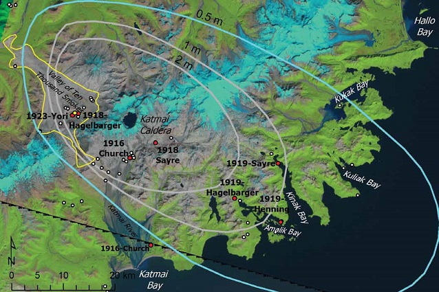
Repeat photographs of the Katmai landscape devastated by volcanism reveal a range of geomorphic and ecological processes affecting the recovery of the region. Photographs were sorted according to four zones of disturbance-intensity, radiating from the 1912 Novarupta eruption site (Figure 1).
Landsat satellite images from 2000 and 2002 (Figure 1) show that revegetation of the ash flow in the valley has been negligible, and in adjacent areas with heavy ash fall (>6.6 ft/2 m) only ~5% of the area has revegetated. As ash depths decrease at greater distances from the eruption site, vegetation cover increases, such that in the areas of lowest ash fall about 70% of the area shows strong vegetation recovery. Impacts from the eruption extended as far as Hallo Bay (Jorgenson et al. 2006) and Kodiak Island (Griggs 1918), and these areas have a nearly complete cover of vegetation today.
Left photograph courtesy of D. Church, copyright NGS. Right photograph courtesy of G. Frost.
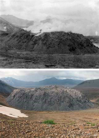
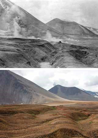
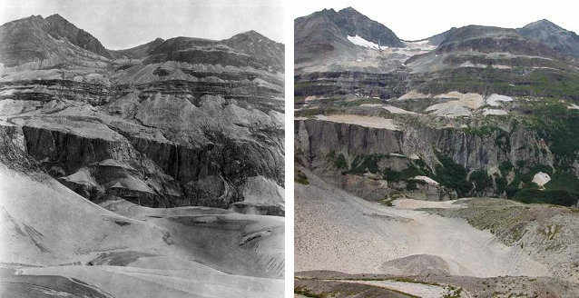
Repeat photographs taken in 2004 and 2005 provide more detailed views of vegetation recovery and are generally consistent with the Landsat imagery (Figures 2-9). Photos from the ash flow in the valley show very little recovery nearly 100 years after the eruption (Figures 2-3). In most of the area, vegetation cover, primarily willows, remained at <1% (visually estimated from photographs). In the >6.6 ft (2 m) ash fall zone, vegetation in 2004 covered 10-30% of the landscape (Figures 4-5). Alder has recovered in isolated patches on the valley slopes, primarily in areas where the ash had been eroded from the hillside by landslides and fluvial processes. Floodplains, however, had <1% cover in 2004 due to active channel migration and scouring (Figure 5). Willows were more abundant in protected drainages, but growth on thicker ash fall deposits remained negligible. In the 3.3-6.6 ft (1-2 m) zone, vegetation that survived the moderate impact covered 10-40% of the landscape soon after the eruption and then increased to cover 70-90% of the landscape by 2005 (Figures 6-7). In the 1.6-3.3 ft (0.5-1 m) zone along the coast, vegetation in 1919 covered 10-40% of the landscape and increased to 90-100% of the landscape by 2005 (Figures 8-9). In the latter two zones, present-day vegetation is dominated by alder scrub and bluejoint-herb meadows. Substantial ecological impacts also occurred beyond the 1.6 ft (0.5 m) isopach; vegetation in 1919 covered only 10-40% of the landscape and increased to nearly 100% of the landscape by 2005, with the exception of active floodplains (Figure 9). While meadows and shrublands have recovered in areas of moderate and low impact, trees that were once common at lower elevations, particularly cottonwood on river floodplains, have shown little recovery.
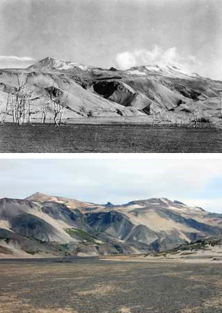
Top photograph courtesy of J. Sayre, copyright NGS. Bottom photograph courtesy of G. Frost.
Recovery of Main Vegetation Types
Vegetation recovery was dominated mainly by four vegetation types: partially vegetated barrens, bluejoint-herb meadows, willow scrub, and alder scrub. Other uncommon vegetation types that recovered well after the eruption included Sitka spruce forests that expanded into areas disturbed by the ash fall, dwarf ericaceous scrub at higher elevations, and halophytic wet meadows on tidal flats.
Partially vegetated and barren areas (<30% vegetation cover) remained widespread in areas of ash flow and heavy ash fall. In the Valley of 10,000 Smokes, common colonizing plants included scattered willows (Salix barclayi and S. alaxensis), rushes (Luzula spp), and bluejoint grass (Calamagrostis canadensis). A few mosses and liverworts were found colonizing the bare soil shortly after the eruption (Griggs 1933) and are still present today. Sitka alder (Alnus viridis ssp. sinuata), however, was virtually absent from the ash flow. Near the coast, common colonizers included grasses (Deschampsia caespitosa, Leymus mollis) and forbs (Chamerion angustifolium, Lupinus nootkatensis, Artemisia tilesii).
Bluejoint-herb meadows were common on slopes interspersed with the alder thickets along the coastal mountains in zones with thinner ash fall. The vegetation was dominated by bluejoint grass, umbels (Heracleum lanatum, Angelica genuflexa), fireweed (Chamerion angustifolium), and other forbs (Geranium erianthum, Achillea borealis, Sanguisorba canadensis).

Top photograph by P. Hagelbarger, copyright NGS. Bottom photograph by T. Jorgenson.
Tall and low willow scrub was common in drainages and in the mountains near the coast. Willows were predominantly Salix barclayi, but included S. sitchensis, S. alaxensis and S. glauca. Numerous dwarf shrubs (Vaccinium vitis-idaea and Empetrum nigrum), bluejoint grass, and forbs (Chamerion angustifolium, Trientalis europaea, Sanguisorba stipulata, Lupinus nootkatensis) were common.
Alder tall scrub was abundant in the coastal mountains affected by moderate to light ash fall. Early photographs showed scattered, live tall shrub thickets on many of the steeper mountain slopes where ash cover did not persist. By 2005, Sitka alder and various willows (Salix barclayi, S. sitchensis, and S. alaxensis) up to 15 ft (4.5 m) tall were co-dominant in the overstory. Scattered Sitka spruce (Picea sitchensis) and black cottonwood (Populus balsamifera ssp. trichocarpa) occasionally were present. The initial survival of scattered alder patches in the coastal mountains undoubtedly aided recovery through expansion of surviving shrubs and by providing a seed source for new recruitment. The understory of alder scrub has most of the plants found in bluejoint herb meadows.

Left photograph courtesy of J. Sayre, copyright NGS. Right photograph courtesy of T. Jorgenson.
Sitka spruce woodlands appear to have expanded into new habitats in a few locations. In 1919, Sitka spruce was observed on a peninsula in Kuliak Bay and a small islet at the mouth of Amalik Bay (Griggs 1934). By 2005, spruce forest had increased markedly in Kukak Bay where they were not previously evident (live or dead) in 1919 (Jorgenson et al. 2006). Sitka spruce has also spread quickly on Kodiak Island due to the early presence of trees that provided a seed source and the occurrence of a mineral seedbed following the eruption, where plant competition at the seedling stage was minimal (Griggs 1918, Tae 1997).
At Hallo Bay, salt marshes received 4-12 in (10-30 cm) of ash and subsequently were covered by silt from tidal flooding and eolian sand. Today the coastal landscapes now support productive salt marshes on narrow tidal flats and dunegrass meadows on beaches.
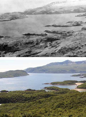
Top photograph courtesy of W. Henning, copyright NGS. Bottom photograph courtesy of T. Jorgenson.
Factors Affecting Recovery
The ecological recovery of the areas disturbed by ash flow and fall has been greatly affected by geomorphic processes and the chemical properties of the ash deposits (Griggs 1919, 1922, 1933). On slopes, much of the ash has been removed through landslides, slumping, fluvial erosion, and wind erosion (Figure 4). High winds that cause severe surface abrasion, particularly in the Valley of 10,000 Smokes, are common and undoubtedly retard plant establishment. Gully formation is prevalent in flat areas of the valley where the original drainage patterns were obliterated by the ash flow (Figure 3). Floodplain dynamics were greatly affected as heavy ash fall immediately increased suspended- and bed-loads within the channel, and heavy sediment input probably continued for many years after the eruption (Griggs 1919). Within a decade, the upper reaches of high-energy, braided floodplains had been mostly cleared of fine-grained cover deposits of ash (Figure 5), but lower reaches and deltas continue to have very active channel migration in the highly mobile sandy materials (Figure 9).
Soil chemistry and low nutrient-availability are major factors contributing to the slow recovery of vegetation on thick ash deposits. Katmai ash is mainly comprised of rhyolite and dacite, which are dominated by quartz and potassium- and sodium-rich feldspars (aluminum- and silica-rich). Griggs (1933) attributed the slow revegation to the very low nitrogen concentrations (<0.02% total nitrogen) in unmixed ash. These nutrient-limited ash deposits favor species with symbiotic nitrogen-fixing bacteria, such as alder and legumes. While alder has recovered well in areas with light to moderate ash deposits, alder has not shown much recovery on thick ash fall and especially on the ash flow in the Valley of 10,000 Smokes. Katmai ash also has very low phosphate concentrations (0.4% phosphoric acid), which also strongly limits plant growth. Finally, aluminum oxide concentrations are high (13.9% Al2O3) (Griggs 1933), which suggests high aluminum solubility, and consequent toxicity, may be a factor in acidic soils formed from rhyolite. Low soil moisture in coarse-grained pumice deposits may be a factor in limiting seedling establishment, but seedling establishment and recovery typically are rapid on other newly exposed gravelly substrates that are common in Katmai, such as landslides, glacial moraines, and riverbars. The astonishing lack of recovery of the ash deposits over much of the area after nearly 100 years warrants more detailed investigation.
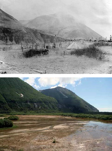
Top photograph courtesy of D. Church, copyright NGS. Bottom photograph courtesy of T. Jorgenson
Acid rain and highly corrosive sulfuric acid gasses likely affected vegetation even where ash fall was very light. Photographs of granitic outcrops west of the eruption along Lake Grosvenor in 1919 document white, barren bedrock outcrops, which have subsequently become nearly entirely covered by crustose and fruticose lichens (Jorgenson et al. 2006). Acid rain from the eruption was reportedly so strong that it caused clothing to disintegrate on clotheslines in Vancouver, Canada. Recent investigations of widespread vegetation damage near Chiginagak Volcano on the Alaska Peninsula attributed the heavy mortality to a gaseous flow of sulfuric acid aerosols generated by catastrophic drainage of the crater lake (Schaefer et al. 2008).
In summary, the 1912 eruption at Katmai devastated a large area of southwestern Alaska through ash fall and pyroclastic flows, and its impacts extended globally. The spectacular effects of the Katmai eruption created a unique natural laboratory in which to study ecological recovery along a gradient of disturbance levels and ecosystem types, ranging from primary succession on the sterile soils of the Valley of 10,000 Smokes, to secondary succession after ash fall. Repeat photography offered an effective and highly engaging technique to monitor this recovery over a centennial time-scale. Ecological recovery occurred remarkably quickly in many areas, but the otherworldly landscape of the valley remains almost entirely barren a century after it was created. The amazing lack of revegetation in some areas that had thick pyroclastic flows and ash deposits warrants more research into what factors are limiting plant recovery.
Acknowledgements
We thank Tahzay Jones for field help with some of the Katmai photos, Dorothy Mortenson for improving the photographic database, and Troy Hamon for facilitating our work in the park. Joe McGregor at the USGS Photographic Library, Bill Bonner at the NGS Photographic Archive, and Kathryn Myers at the Lake Clark-Katmai Studies Center helped locate historical photographs.
References
Clemens, J., and F. Norris. 1999. Building in an ashen land: Historic Resource Study of Katmai National Park and Preserve. National Park Service. Anchorage, Alaska.
Griggs, R.F. 1918. The recovery of vegetation at Kodiak. The Ohio Journal of Science 19: 1-57.
Griggs, R.F. 1919. The beginnings of revegetation in Katmai Valley. The Ohio Journal of Science 19: 318-342.
Griggs, R.F. 1922. The Valley of Ten Thousand Smokes. National Geographic Society. Washington, D.C.
Griggs, R.F. 1933. The colonization of the Katmai ash, a new and inorganic “soil”. American Journal of Botany 20: 92-113.
Griggs, R.F. 1934. The edge of the forest in Alaska and the reasons for its position. Ecology 15(2): 80-95.
Hall, F.C. 2002. Photo-point monitoring handbook. Pacific Northwest Research Station, U.S. Forest Service. Portland, OR. PNW-GTR-526.
Hildreth, W., and J. Fierstein. 2003. Geologic Map of the Katmai Volcanic Cluster, Katmai National Park, Alaska. U.S. Geological Survey. Washington, D.C. Geologic Investigations Series I–2778.
Jorgenson, M.T., G.J. Frost, W. Lentz, and D. Mortenson. 2006. Photographic monitoring of landscape change in the Southwest Alaska Network of National Parklands, 2004-2006. National Park Service. Anchorage, AK. NPS/SWAN/NRTR-2006/03.
Martin, G.C. 1913. The recent eruption of Katmai volcano in Alaska. National Geographic Magazine 24: 131-181.
Schaefer, J.R., W.E. Scott, W.C. Evans, J. Jorgenson, R.G. McGimsey, and B. Wang. 2008. The 2005 catastrophic acid crater lake drainage, lahar, and acidic aerosol formation at Mount Chiginagak volcano, Alaska, USA: Field observations and preliminary water and vegetation chemistry results. Geochemistry, Geophysics, Geosystems 9: Q07018.
Smith, W.R. 1925. The Cold Bay-Katmai district, in Mineral Resources of Alaska - Report on Progress of Investigations in 1923. U.S. Geological Survey Bulletin 773: 183-207.
Tae, K.E. 1997. Processes controlling the range expansion of Sitka Spruce on Kodiak Island, Alaska. M.S. Thesis. University of Alaska, Fairbanks.
Part of a series of articles titled Alaska Park Science - Volume 11 Issue 1: Volcanoes of Katmai and the Alaska Peninsula.
Last updated: August 18, 2017
