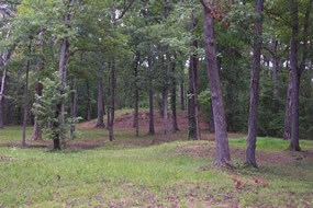
(NPS Photo) About 800 years ago, a town occupied the high Tennessee River bluff at the eastern edge of the Shiloh plateau. Between two steep ravines, a wooden palisade enclosed seven earthen mounds and dozens of houses. Six mounds, rectangular in shape with flat tops, probably served as platforms for the town’s important buildings. These structures may have included a council house, religious buildings, and residences of the town’s leaders. The southernmost mound is an oval, round-topped mounds in which the town’s leaders or other important people were buried. This town was the center of a society that occupied twenty-mile-long stretch of the Tennessee River Valley. Around A.D. 1200 or 1300, inhabitants moved out of this part of the Tennessee Valley, perhaps to upriver locations now submerged under Pickwick Lake. Since the Shiloh society disintegrated several hundred years before there were written records to tell us who they were, it is not clear whether or how the Shiloh residents were related to later societies like the Choctaw, Chickasaw, or Creek. Archaeologists refer to the society centered at Shiloh as a “chiefdom.” The chief would have been the most important political leader as well as religious figure. Probably a council, composed of elders and respected members of the community, shared power with the chief. Close relatives of the chief would have been treated like nobility; some were probably buried in “Mound C.” The Residents of the Shiloh site were farmers. Corn (maize) was their most important food. They also grew squash and sunflowers, as well as less familiar crops such as goosefoot, marshelder, and maygrass. In addition to their cultivated crops, they also ate a wide variety of wild plants and animals. The most important wild plant foods were hickory nuts and acorns. Most of their meat came from deer, fish, turkey, and small animals such as raccoon, rabbit, and squirrel. In addition to the Shiloh site, the chiefdom included six smaller towns, each with one or two mounds, and isolated farmsteads scattered on higher ground in the river valley. Downstream on the river’s eastern bank, Savannah, Tennessee, marks the site of another palisaded settlement with multiple mounds. Many of the Savannah mounds were actually built much earlier, about 2000 years ago, but the site was reoccupied at roughly the same time as the Shiloh site. We don’t know whether these two towns were occupied at exactly the same time. Modern buildings in Savannah have obliterated most of the prehistoric site. The Shiloh chiefdom had as neighbors other chiefdoms in what is now Alabama, Mississippi, and western Tennessee. Most of the chiefdoms occupied portions of the major river valleys, like the Tennessee and Tombigbee. Some of the neighboring chiefdoms would have been hostile to the Shiloh chiefdom, while others were linked to Shiloh by political alliances. Archaeological evidence of these alliances survives in the form of “prestige goods” chiefs exchanged as tokens of their friendship. We can often tell where specific prestige goods were made. If we know where a particular item was made and where it was sent, we can tell who was exchanging with whom. In the case of Shiloh, we can tell political ties existed with a powerful chiefdom at Cahokia, near St. Louis. In contrast, there is no evidence of political ties to chiefdoms in central Tennessee. The First Archaeological excavation at Shiloh took place in 1899 when Cornelius Cadle, chairman of the Shiloh Park Commission, dug a trench into “Mound C.” There, he found the site’s most famous artifact, a large stone pipe carved in the shape of a kneeling man. Now on display in the Tennessee River Museum in Savannah, Tennessee, this effigy pipe is made of the same distinctive red stone and is carved in the same style as a number of human statuettes from the Cahokia chiefdom, located in Illinois near St. Louis. Survey work in the winter of 1933-34 revealed numerous small, round mounds at the Shiloh site, each about one foot high and ten to twenty feet in diameter, the remains of wattle-and-daub houses. These structures had walls of vertical posts interlaced with branches (wattle), which were then coated with a thick layer of clay (daub). Each house had a fireplace in the center of the floor. A palisade wall, also made of wattle and daub, protected the site. The early inclusion of the mounds area within the boundary of the national military park has protected the site from any modern use. Because the Shiloh site has never been disturbed by the plow, the daub of collapsed walls still stands as low rings or mounds. Shiloh is one of the very few places in the eastern United States where remains of prehistoric houses are still visible on the ground’s surface. |
Last updated: April 14, 2015
