Last updated: April 9, 2026
Place
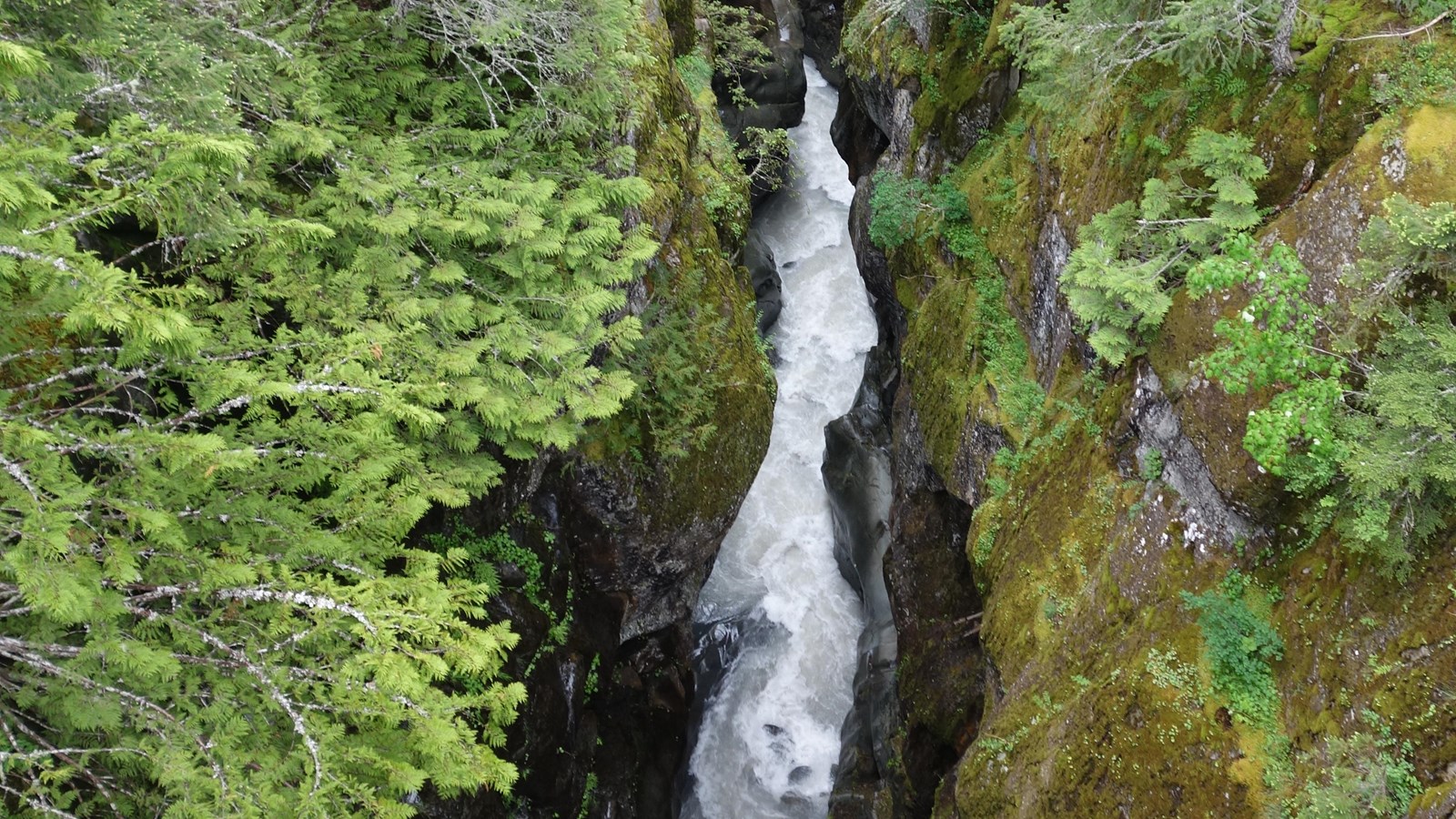
Box Canyon
NPS Photo
Quick Facts
Location:
From the Paradise Road wye, Box Canyon is 8.7 miles east along Stevens Canyon Road, or 10.3 miles if heading west from the Stevens Canyon Entrance.
Significance:
Contributes to the Mount Rainier National Historic Landmark District
Amenities
8 listed
Benches/Seating, Historical/Interpretive Information/Exhibits, Parking - Auto, Picnic Table, Restroom - Seasonal, Scenic View/Photo Spot, Toilet - Vault/Composting, Trailhead
Season: Summer Only (June - September)
Box Canyon is located along Stevens Canyon Road, which is open to vehicles during the summer season only, typically late May-September.
Box Canyon is a narrow slot canyon carved by the Muddy Fork of the Cowlitz River. The Box Canyon Area includes an overlook, comfort station, picnic area, and a short loop trail. NOTE: No potable water or flush toilets available at Box Canyon in 2026.
- The Box Canyon Bridge is part of Stevens Canyon Road and was built between 1950-1952 in the National Park Service rustic style. It is a spandrel arch bridge 160 feet long and about 41 feet wide with a veneer of native granite. The lower Box Canyon Overlook provides an excellent view of the bridge, looking northwest towards Mount Rainier. From the bridge, look down 180 feet below at the Muddy Fork of the Cowlitz River rushing through the narrow slot canyon.
- About 100 feet west of the Box Canyon Bridge, Stevens Canyon Road passes through the Box Canyon Tunnel. The tunnel is 160 feet long. Unlike the other two tunnels found in the park (one further west along Stevens Canyon Road and one on SR123), this tunnel does not have portals covered with masonry and the tunnel walls are bare rock. The tunnel clearance is 12 feet, 6 inches.
- The Box Canyon Picnic Area is located to the west of the tunnel, with a separate parking area.
- The main Box Canyon parking area and comfort station is located east of the bridge.
- From the parking area, a short, paved path leads down to the Box Canyon overlook. Three interpretive exhibit panels provide information about the geology and history of the area.
Hiking
- The Box Canyon Loop Trail is 0.5 miles long and paved. Starting from the east side of Box Canyon Bridge, the trail follows the edge of the canyon northwest towards Mount Rainier, crosses the canyon over a wood footbridge, then follows the other side of the canyon back to Stevens Canyon Road. The western side of the trail does have some steps. Rounded, exposed bedrock borders the trail on the east side of the canyon. Look for fine striations or scratches across the rock’s surface left behind by the movement of past glaciers that once filled this canyon.
- The Box Canyon Loop Trail connects to the Wonderland Trail, which crosses the road over the top of the Stevens Canyon Road tunnel if heading northwest, or climbs towards Indian Bar if heading northeast.